28 Acres Sold to the Highest Bidder
Bidding ends Wednesday, December 11, 2019 | 6:00 PM Eastern
Auction closed.
28 Acres Sold to the Highest Bidder
Bidding ends Wednesday, December 11, 2019 | 6:00 PM Eastern
Auction closed.
Internet Premium: 10.00%
See Special Terms for additional fees
See Special Terms for additional fees
Description
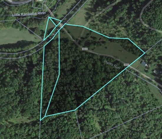
**Easy Access**
**Less than 3 miles to I-79**
28.06 +/- Acres (as assessed by Braxton Co.)
Conveying Any Existing Interest in Mineral Rights
Developable or Recreational Use
Open & Wooded Ground
Potential Timber
Utilities Accessible
GPS Coordinates: 38.861817, -80.698834
Braxton Co. District 7, Map 9C, Parcels 6.2 & 7
Additional Tract to be Conveyed:
Conveying 50% Interest in 0.45 AC. District 7, Map 9C, Parcel 9
NOTE: aerial imagery is from public record and does not reflect a survey or legal description. We are selling based on county assessment and tax map parcel only.

Closed Lots

28 Acres Sold to the Highest Bidder
Lot Size: 28.06 +/- AcresProperty Location - State: West VirginiaProperty Location - County: BraxtonAPN/Parcel ID: District 7, Map 9C, Parcels 6.2 & 7City: BurnsvilleStreet: Hyers Run Road
28.06 +/- Acres Sold to the Highest Bidder
**Easy Access**
**Less than 3 miles to I-79**
28.06 +/- Acres (as assessed by Braxton Co.)
Conveying Any Existing Inter...more
