Singleton Farms Auction
Auction closed.
Auction closed.
Singleton Farms Auction
Auction closed.
Auction closed.
Internet Premium: Tiered
See Special Terms for additional fees
See Special Terms for additional fees
Description
This is 1 of 2 Auctions, the equipment is listed under SINGLETON FARM AND EQUIPMENT AUCTION. Harrison Auction and Realtor would like to welcome everyone to an Online Only Auction featuring Land and Equipment in Caddo County 5 miles south of Cogar. After a Lifetime of Farming and Ranching Larry and Judy Singleton have decided to retire. They are offering two Great Tracts of Property 160 +/- Acres Surface Rights Only and 143 +/- Acres Surface Rights Only, Vehicles, Trailers, Equipment, Livestock Equipment, Hay, and Tools. These properties offer Farming, Ranching, and Hunting opportunities.

Need help with bidding? Get Help

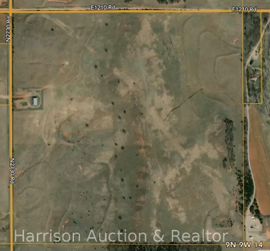
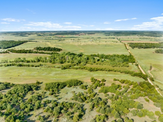
NORTHWEST QUARTER 160 +/- Acres SECTION 14, 9 NORTH, 9 WEST
Quantity: 160
Lot Size: 160Sq. Feet: 6,969,600Property Location - City: MincoProperty Location - Country: United StatesProperty Location - State: OklahomaProperty Location - County: caddoProperty Location - Postal/Zip Code: 73059APN/Parcel ID: 00001409N09W200500Taxes: 250School District: gracemont
NORTHWEST QUARTER 160 +/- Acres SECTION 14, 9 NORTH, 9 WEST
This Black Top Frontage of 160 +/- Acres has Bermuda and Love Grass Pastures that are established and is cross fenced. This property would be ideal for Hunters, Farming, Ranching, Homestead, and much more. Hunters have a wide range of opportunities to hunt Deer, Turkey, Hogs, Quail, and Dove.There is a water well and 2 catch ponds for water sources. The Open sided Barn is approximately 42ft by 82 ft and has a good gated entry from the Black Top Road.
Distance to Nearby Cities and or Towns
This Property is approximately 25 miles to Anadarko, 30 miles to Chickasha, 35 miles to El Reno,35 miles to Ft. Cobb Lake, 40 miles to Yukon, and 50 miles to Weatherford.
PARCEL ID 00001409N09W200500
LOCATION Caddo County, OK 9N 9W ? 10, 11, 14, 15
Tax ID 0000-14-09N-09W-2-005-00
Alt APN 080007720
School District Name Gracemont
Land Use - Universal Agricultural (NEC)
Lot Acres 160
Land Use - County Rural Agricultural
Lot Area 6,969,600 FT
Legal Description T09N R09W S14 NW NW
Directions: From HWY 81 North of Minco 1 Mile, Go West on HWY 152 approximately 12 miles to N 2730 Road, Thence 5 Miles South. AND IT WILL BE THE FARM ON EAST SIDE OF ROAD.
Google Plus Code 7V59+JVP Spring Creek, Oklahoma
Google Maps: https://goo.gl/maps/V1aPpqT4Ux4CHWn7A
For Google maps link please copy and paste link into Google.
$2,550.00 x 160 = $408,000.00 Total

NORTHEAST QUARTER 143 +/- Acres SECTION 15, 9 NORTH, 9 WEST
Quantity: 143
Lot Size: 143Property Location - Address: County Street 2730Property Location - City: MincoProperty Location - Country: United StatesProperty Location - State: OklahomaProperty Location - Postal/Zip Code: 73059Property Location - County: caddoAPN/Parcel ID: 080049458Taxes: 250School District: Gracemont
NORTHEAST QUARTER 143 +/- Acres SECTION 15, 9 NORTH, 9 WEST
This 143 +/- Acres has Black Top Frontage and has Approximately 100 Acres of Cropland, 17 Acres of established Alfalfa, and the remaining Acres are Bermuda and or Native Grassland. This Property is Cross Fenced. This Property has water sources that include a Water Well, a Live Creek known as Stinking Creek, and a Pond. There are Pipe Corrals with East Side Gated Black Top Road Entry and North Gravel Road Entry. This property would be ideal for Hunters, Farming, Ranching, Homestead, and much more. Hunters have a wide range of opportunities to hunt Deer, Turkey, Hogs, Quail, and Dove.
LOCATION Caddo County, OK 9N 9W ? 10, 15
PARCEL ID 00001509N09W100505
Tax ID 0000-15-09N-09W-1-005-05
Alt APN 080049458
Legal Description NE (LESS 17.50 AC# 7724) T09N R09W S15 NE
Distance to Nearby Cities and or Towns
This Property is approximately 25 miles to Anadarko, 30 miles to Chickasha, 35 miles to El Reno,35 miles to Ft. Cobb Lake, 40 miles to Yukon, and 50 miles to Weatherford.
Directions: From HWY 81 North of Minco 1 Mile, Go West on HWY 152 approximately 12 miles to N 2730 Road, Thence 5 Miles South. AND IT WILL BE THE FARM ON WEST SIDE OF ROAD. MINUS THE HOUSE AND 17 ACRES AROUND HOMESTEAD.
Google Plus Code 7V59+JVP Spring Creek, Oklahoma
Google Maps: https://goo.gl/maps/V1aPpqT4Ux4CHWn7A
For Google maps link please copy and paste link into Google.
$3,050.00 x 143 = $436,150.00 Total
