Diversify Your Portfolio Today: Land Liquidation!
Diversify Your Portfolio Today: Land Liquidation!
See Special Terms for additional fees
Description


Three-Lot Package in Antrim, Michigan: The Perfect Spot to Build Your Dream Home!
Parcel IDs: 05-11-450-100-00, 05-11-450-223-00, and 05-11-450-302-00
Legal Descriptions: See photo for 3 legal descriptions
Acre: 1.33
State: Michigan
County: Antrim
Taxes: Under $15 per month
Enjoy the four seasons in the Lakes of the North community in Antrim County. This peaceful and quiet location transforms seasonally from snow-covered white in winter, to spring green, to comfortable summer days, then magnificent shades in fall. The community is located about 20 minutes from Boyne Mountain Resort and Shanty Creek Resort; and 45 minutes from Traverse City or 25 minutes from Gaylord.
Things to See & Do in Antrim County! >>
Lakes of the North is a group of 19 subdivisions that straddles the Otsego-Antrim county line.
This package of three lots, totaling 1.33 acres, is located in the Manistee Heights subdivision.
Learn About Lakes of the North Association >>
Each vacant lot in Lakes of the North is buildable and is rural in character. All building plans need approval by the association's Architectural Control Committee. Lots do not have water, septic, or electricity. Construction would require a private well and sewage disposal system. If there is electricity in the area, it can be extended to your lot.
Building restrictions include a minimum square footage that varies by subdivision. Mobile homes, trailers, camping and storage are prohibited on all vacant lots. Commercial use is also prohibited (including for rentals and short-term rentals).
For complete building information, please see Lakes of the North – Restrictive Covenants, paying particular attention to Article VI (Architectural Control Committee) and Article VII (Building and Use Limitations).
Amenities include an 18-Hole Golf Course, Pro-Shop, full-service Restaurant/Tavern all of which are Open to the Public. Member exclusive areas include Pencil Lake and Harold Lake beach access and beach houses, Activities Clubhouse with a Pool, Whirlpool, Water Slide, along with two outdoor Tennis/Pickleball Courts, Shuffleboard, Horseshoes and playground.
The Winter Sports area has an Ice Rink, Cross Country Ski and Snowshoe trails which serve as hiking trails in the summer.
Campers Village is an all-season facility for members to enjoy with their camper.
Throughout and surrounding Lakes of the North you will find hundreds of miles of ATV/Snowmobile Trails to ride on.
Lakes of the North is known for its picturesque landscapes, featuring serene lakes surrounded by lush forests and offering a peaceful retreat for residents and visitors alike. Bid now!
NOTE: The Association’s 2024 annual assessment is $332 for the first lot, covering the year from April 1, 2024 to March 31, 2025. Each additional lot is an annual fee of $166.00. The buyer will be responsible for payment of the amount of the annual assessment in the fiscal year when the deed is recorded. The buyer must also register with the Association as a land owner by completing the required document (to be provided along with the recorded deed).
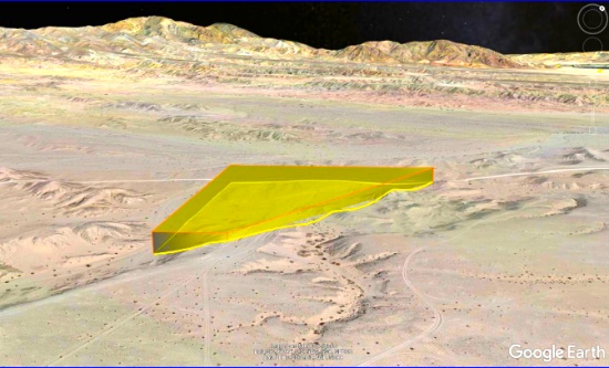
Nearly 12 Acres of Possibilities by California's Salton Sea!
NOTE: Click on the Approximate Coordinates link below to explore the area on Google Maps. Zoom in for a detailed view of local attractions, roads, etc., or zoom out for a wider perspective of the surrounding region.
Parcel ID: 007-700-016-000
Legal Description: LOT 52 TRACT 736
Acre: 11.57
State: California
County: Imperial
Taxes: Under $12 per month
Approximate Coordinates: 33°16'37.7"N 116°00'54.7"W
Bring your jeep, dune buggy or other off-road vehicle to explore the diverse surroundings in Southern California!
In recent news, the Salton Sea area has attracted attention as a huge source of lithium, used in electric vehicle lithium-ion batteries. The California Energy Commission estimates that there’s enough lithium there to surpass the current production now existing worldwide! Several companies have begun exploring the potential for lithium extraction, boding well for future employment opportunities.
Read about Salton Sea area Lithium Extraction >>
This 11.57 acre parcel is located in the rolling hills of Imperial County, located just a few miles from Salton City, about 35 minutes from "Anza-Borrego Desert State Park", and only 15 minutes from the "Red Earth Casino".
Imperial County shares borders with Mexico to the south, Riverside County to the north, San Diego County to the west, and the State of Arizona to its east.
Cibola National Wildlife Refuge straddles the border of California and Arizona. It has an abundance of wildlife watching and nature trail opportunities. Take the Canada Goose Drive for an excellent opportunity for wildlife viewing and photography. On the accessible walking trail, you might see song birds, bobcats, quail, and mule deer. Anglers can fish for largemouth bass, smallmouth bass, striped bass, channel catfish, flathead catfish, crappie, sunfish, tilapia, and common carp. Public hunting on Cibola National Wildlife Refuge is permitted in specified areas.
Experience the Cibola National Wildlife Refuge >>
Head to the city of Brawley, about an hour away, ranked in the top 10 fastest growing cities in California, for provisions, food and entertainments!
Learn about the City of Brawley >>
So much adventure is awaiting you here! If you are looking for a large, remote piece of land to get away from it all, this is for you!

Build Your Dream Home in the Heart of Saginaw, Michigan!
NOTE: Click on the Approximate Coordinates link below to explore the area on Google Maps. Zoom in for a detailed view of local attractions, roads, etc., or zoom out for a wider perspective of the surrounding region.
Parcel ID: 10-12-5-29-1184-700
Legal Description: N 25 FT OF LOT 84 AND S 30 FT OF LOT 85 HOLLAND GROVE SEC 29 T12N R5E
Acre: 0.16
State: Michigan
County: Saginaw
Taxes: Under $3 per month
Approximate Coordinates: 43°25'08.5"N 83°54'21.1"W
Build in this established neighborhood in Saginaw, Michigan!
This lot is close to Jessie Loomis Elementary School, Saginaw Children's Zoo, parks, and close to the Saginaw River, 20 miles inland from the Saginaw Bay, an arm of Lake Huron. Along with Bay City and Midland, Saginaw forms the tri-city area.
Saginaw has a good balance of services and facilities for a city of its size and profile, including technology, higher education, healthcare, air service, cultural amenities, as well as being rich in history.
This is Saginaw. We Build Opportunity! >>
Saginaw is the gateway to recreational areas in northern Michigan. There is a small Old Town entertainment district across the Saginaw River and there are many interesting things to do there.
15 Best Things to do in Saginaw >>
This diverse city has opportunities in abundance for both outdoor and indoor adventures. From iconic locales to theaters and museums, there's plenty of things to do in Saginaw, including catching a show at the Dow Event Center or the Temple Theatre, viewing artwork at the Saginaw Art Museum, or spending the day at the Children's Zoo and much more.
Discover a city steeped in arts & culture — with hidden gems & unexpected delights around each historic, mural-covered street corner!

Build in Beautiful Modoc County in Northeast California!
NOTE: Click on the Approximate Coordinates link below to explore the area on Google Maps. Zoom in for a detailed view of local attractions, roads, etc., or zoom out for a wider perspective of the surrounding region.
Parcel ID: 039-032-017-000
Legal Description: Lot 38, Block 6, California Pines Lake Unit 1B, a subdivision of the County of Modoc according to the official Plat thereof, filed in Book 2 of Maps in Modoc County Records.
Acre: 0.15
State: California
County: Modoc
Taxes: Under $13 per month
Approximate Coordinates: 41°24'40.0"N 120°40'58.4"W
Nestled in the northeastern corner of California, Modoc County is a tranquil and picturesque haven filled with untouched natural beauty and a laid-back, small-town charm. This county boasts rolling meadows, pristine lakes, and towering mountains, offering outdoor enthusiasts a playground for hiking, hunting, fishing, and wildlife observation. Alturas, the commercial center for northeastern California, is less than 15 minutes away.
What to Do and See in Modoc County >>
The warm, dry summers encourage camping, hiking, fishing, and water sports against the backdrop of the uniquely beautiful Warner Mountains, with their clear alpine streams and a high desert dotted with serene lakes.
This 0.15 acre property in Lake Unit 1B is ready to build with close-by sewer and water connections, as well as an underground electrical power box at the curb. The Lake Units are located at an elevation of 4,300 feet in mostly meadow pasture land type of property.
RVs and camping are permissible for up to 30 days of a calendar year.
If you are considering constructing a home, please note that the living space must be no less than 1000 square feet.
Building in California Pines! >>
The California Pines Property Owners Association maintains common areas for the benefit of the property owners, residents and the general public.
The California Pines Lake is 256 acres and next to it sits the California Pines Lodge, a 4,400 feet airstrip, and campground. The 8,000 square foot lodge features guest rooms, a restaurant, lounge, banquet room and activity room. The grounds of the lodge also include a swimming pool.
See the California Pines Lodge >>
This lot offers a unique opportunity to embrace the serenity and natural wonders of Modoc County. It's a piece of paradise waiting for you to call it home!
NOTE: The annual POA fee is $105 and will become the responsibility of the buyer.

Stunning Holbrook, Arizona: 1.31 Acre Retreat!
NOTE: Click on the Approximate Coordinates link below to explore the area on Google Maps. Zoom in for a detailed view of local attractions, roads, etc., or zoom out for a wider perspective of the surrounding region.
Parcel ID: 105-59-144
Legal Description: Rancho #96 Lot 32
Acres: 1.31
State: Arizona
County: Navajo
Taxes: Under $5 per month
Approximate Coordinates: 35°04'03.6"N 110°03'04.1"W
Welcome to the Grand Canyon State, Arizona!
This 1.31 acre property in Holbrook, Navajo County, Arizona. Navajo County is located in the northeastern part of Arizona, and named after the Navajo Nation. Immerse yourself in the beauty of this one of a kind, diverse culture!
Navajo County is characterized by diverse landscapes, including high desert areas, forests, and the iconic Painted Desert. The Petrified Forest National Park, known for its fossilized trees and colorful rock formations, is partly located in the county.
This property is conveniently located just an hour's drive from the Petrified Forest National Park. To the south lies the vibrant Rainbow Forest, showcasing an array of colorful petrified wood. The Rainbow Forest Museum, featuring paleontology exhibits and numerous trail access points, adds to the allure. In the park's central region, visitors can explore the petroglyphs at Newspaper Rock and the historic remains of Puerco Pueblo. Heading north, the Painted Desert Inn, a charming 1930s adobe building, serves as a museum adorned with captivating Hopi murals.
Things To Do: Petrified Forest National Park >>
You can easily get lost in the history, beauty, and culture of this wondrous city. From star gazing, hiking trails, campgrounds, national monuments, historical parks, museums, trading posts, and the Twin Arrows Casino Resort, there is definitely something for everyone!
Don't miss out on the opportunity to own property in this beautiful state!

Lake County, Michigan: A Paradise of Lakes and Adventure!
NOTE: Click on the Approximate Coordinates link below to explore the area on Google Maps. Zoom in for a detailed view of local attractions, roads, etc., or zoom out for a wider perspective of the surrounding region.
Parcel ID: 11-402-001-00
Legal Description: LOTS 1 & 2 BLK 2 LAKEWOODS ACRES.
Acre: 0.14
State: Michigan
County: Lake
Taxes: Under $2 per month
Approximate Coordinates: 43°55'16.8"N 85°51'01.2"W
Welcome to Lake County, Michigan: The Home of Over 100 Lakes!
This property, located on Lorriane Street in Baldwin, is less than a mile from three lakes: Government, Mench and Cashion! In addition, it's just a short drive to Putman Lake, Little Star Lake, Bush Lake, Baldwin Municipal Airport, Perre Marquette State Trail, and several campgrounds!
Baldwin is a charming village nestled in Lake County, Michigan. Situated amid beautiful natural surroundings, it's known for its proximity to various lakes, rivers, and forests, making it a haven for outdoor enthusiasts.
Learn More About Baldwin, MI >>
The town has a small, tight-knit community that embraces its rural character. It's a hub for fishing, hunting, hiking, and other outdoor activities, attracting visitors and residents seeking an escape into nature. The Pere Marquette River, famous for its trout fishing, flows through this area, drawing anglers from far and wide.
Tourism Activities in Baldwin >>
The Pere Marquette, the Pine, and the Little Manistee are a few of the 16 National Wild and Scenic Rivers in Michigan. These rivers and their many tributaries also provide wonderful scenic canoeing and even some whitewater kayaking.
Baldwin hosts events and festivals throughout the year, celebrating its heritage and natural bounty. The surrounding Manistee National Forest offers extensive trails for hiking, biking, and snowmobiling, providing year-round recreational opportunities.
Huron-Manistee National Forest >>
Pere Marquette State Forest >>
Despite its small size, Baldwin provides essential amenities like local shops, restaurants, and accommodations, catering to both tourists and residents. Overall, it's a serene and picturesque destination, especially appealing to those seeking a tranquil lifestyle amidst Michigan's stunning natural landscapes!

Valencia County: New Mexico is Booming!
NOTE: Click on the Approximate Coordinates link below to explore the area on Google Maps. Zoom in for a detailed view of local attractions, roads, etc., or zoom out for a wider perspective of the surrounding region.
Parcel ID: 1022034137165000000
Legal Description: Subd: RIO DEL ORO Lot: 52-3 Block: 52 Unit: 26 .50 AC 2004 REV
Acre: 0.5
State: New Mexico
County: Valencia
Taxes: Under $5 per month
Approximate Coordinates: 34°44'42.1"N 106°30'56.5"W
Here's your chance to invest in land just minutes from the Manzano Expressway! It's an excellent time to invest in this prime location and the bright future of Valencia County, NM.
July 2024 Update: Approval was recently granted to rezone 268 acres of vacant land, primarily located between NM47 and 304, for manufacturing operations. This bodes well for the continued growth of Valencia County. Development usually breeds development, development brings jobs, and jobs bring people, usually families, who need housing!
Tens of thousands of new jobs are coming to Los Lunas. Facebook (Meta's) new facility opened in 2019 and continues to grow and generate additional economic benefits to the surrounding areas. The White House recently provided a grant to develop infrastructure for a huge new manufacturing facility. A new rail park is also under development.
Of course, more jobs in this sizzling investment area means greater demand for land.
Facebook (Meta) announces $800M expansion plan for Los Lunas Data Center >>
Once the expansion is completed, the Facebook (Meta) Data Center will employ 400 employees and provide significant economic benefits to the local community.
Facebook (Meta) Los Lunas Data Center and Facebook (Meta) Los Lunas Data Center Drone Video >>
New Facebook (Meta) Data Center + Booming Business in Los Lunas >>
In addition, the Cibola National Forest is just to the east and covers more than 1.6 million acres in New Mexico, with elevations ranging from 2,700 feet to over 11,300 feet. If you and your family enjoy picnicking, backpacking, camping, skiing, hiking, wildlife-viewing, star-gazing, horseback-riding, hunting, or mountain biking, Cibola National Forest has plenty to offer you.
See the beautiful mountains of Valencia County >>
Additionally, this property is located about 45 minutes from the Albuquerque International Airport (ABQ).
Note: Back taxes of up to $200 will be the responsibility of the buyer.

Cherokee Village, Arkansas; 20 Lot Package! BIDDING IS PER LOT!
Quantity: 20
Parcel ID: See photo for 20 parcel IDs
Legal Description: See photo for 20 legal descriptions
Acre: 6.89 total
State: Arkansas
County: Sharp
Taxes: Under $240 per month
BIDDING IS PER LOT FOR A CASH PURCHASE!
TOTAL BID PRICE = BID PER LOT x 20 LOTS.
Discover Serenity in the Arkansas Ozarks: Embrace a Beautiful Four-Seasons Lifestyle!
This package of 20 lots is available in Sharp County, Arkansas. The lots are scattered throughout Cherokee Village, but some lots are contiguous!
Experience Cherokee Village >>
This is a great community for a part-time retreat or a full-time residence, for those considering retirement, a new start for their family, or just ready for a change! Cherokee Village offers small town charm, first-class outdoor recreation amenities, and affordability. Take advantage of the low taxes, low cost of living and low housing costs. Your housing dollars stretch further here.
Cherokee Village Information >>
A home may be constructed on each of these lots as long as the house size is a minimum of 800 square feet and complies with the zoning set forth in Cherokee Village Zoning "Bill of Assurance". The lots are located in the following subdivisions:
Bill of Assurance - Crow First >>
Bill of Assurance - Crow Second >>
Bill of Assurance - Crow Fourth >>
Bill of Assurance - Vegas Second >>
Cherokee Village is the perfect backdrop for your next adventure. Come enjoy the lakes, river, golf courses, parks, trails, RV and campground. With more than 13,000 acres set among the rolling hills and pristine natural beauty of the Arkansas Ozarks, Cherokee Village has something to offer all ages.
Cherokee Village, Arkansas - Retreat, Rest and Renew >>
Soak up the sun on the private beach, hit the links on two private 18-hole golf courses, jump right into any of the six swimming pools, go RVing and camping, take a swing at pickleball and tennis, spend the day fishing, walk any of the nature trails, workout at the fitness center, meet some new friends at the senior center, cycle, hike, or just relax in a hammock!
Boat, fish and play on any of the seven lakes or neighboring Spring River.
As the owner of these 20 lots, the possibilities are endless!
NOTE: Real estate taxes are current. The buyer will be responsible for all real estate taxes billed on March 1, 2025 that will be due October 15, 2025.

Antrim County: This Michigan Lot is Magnificent!
NOTE: Click on the Approximate Coordinates link below to explore the area on Google Maps. Zoom in for a detailed view of local attractions, roads, etc., or zoom out for a wider perspective of the surrounding region.
Parcel ID: 05-11-450-488-00
Legal Description: LOT 1043 PLAT OF MANISTEE HEIGHTS NO 2
Acre: 0.65
State: Michigan
County: Antrim
Taxes: Under $5 per month
Approximate Coordinates: 44°56'07.6"N 84°51'22.5"W
Enjoy the four seasons from your new home in the Lakes of the North community in Antrim or Otsego County. This peaceful and quiet location transforms seasonally from snow-covered white in winter, to spring green, to comfortable summer days, then magnificent shades in fall. The community is located about 20 minutes from Boyne Mountain Resort and Shanty Creek Resort; and 45 minutes from Traverse City or 25 minutes from Gaylord.
Things to See & Do in Antrim County! >>
Lakes of the North is a group of 19 subdivisions that straddles the Otsego-Antrim county line.
Amenities include an 18-Hole Golf Course, Pro-Shop, full-service Restaurant/Tavern all of which are Open to the Public. Member exclusive areas include Pencil Lake and Harold Lake beach access and beach houses, Activities Clubhouse with a Pool, Whirlpool, Water Slide, along with two outdoor Tennis/Pickleball Courts, Shuffleboard, Horseshoes and playground.
The Winter Sports area has an Ice Rink, Cross Country Ski and Snowshoe trails which serve as hiking trails in the summer.
Campers Village is an all-season facility for members to enjoy with their camper.
Throughout and surrounding Lakes of the North you will find hundreds of miles of ATV/Snowmobile Trails to ride on.
Learn About Lakes of the North Association >>
This lot is located in the Manistee Heights No 2 subdivision near Pencil Lake and the golf course.
Each vacant lot in Lakes of the North is buildable and is rural in character. All building plans need approval by the association's Architectural Control Committee. Lots do not have water, septic, or electricity. Construction would require a private well and sewage disposal system. If there is electricity in the area, it can be extended to your lot.
Building restrictions include a minimum square footage that varies by subdivision. Mobile homes, trailers, camping and storage are prohibited on all vacant lots. Commercial use is also prohibited (including for rentals and short-term rentals).
For complete building information, please see Lakes of the North – Restrictive Covenants >>, paying particular attention to Article VI (Architectural Control Committee) and Article VII (Building and Use Limitations).
Lakes of the North is known for its picturesque landscapes, featuring serene lakes surrounded by lush forests and offering a peaceful retreat for residents and visitors alike. Bid now!
NOTE: The Association’s 2024 annual assessment is $332 covering the year from April 1, 2024 to March 31, 2025. The buyer will be responsible for payment of the amount of the annual assessment in the fiscal year when the deed is recorded. The buyer must also register with the Association as a land owner by completing the required document (to be provided along with the recorded deed).

Oscoda, Michigan: Own Land by a Golf Course!
NOTE: Click on the Approximate Coordinates link below to explore the area on Google Maps. Zoom in for a detailed view of local attractions, roads, etc., or zoom out for a wider perspective of the surrounding region.
Parcel ID: 005-788-191-00
Legal Description: T28N R1E SEC 16 - UNIT 191 OF GARLAND WOODS ON THE FOUNTAINS GOLF COURSE IV.
Acre: 0.70
State: Michigan
County: Oscoda
Taxes: Under $12 per month
Approximate Coordinates: 44°48'51.5"N 84°19'49.8"W
Check out the Garland Lodge & Golf Resort >>
Despite its rural setting, Oscoda County maintains a rich history and a sense of community pride. Visitors and residents alike can enjoy local events, fairs, and festivals that celebrate the unique culture and traditions of the region.
Learn More about Oscoda County, MI >>
NOTE: The Association’s Architectural Control Committee sets the minimum architectural requirements for home construction, including exterior construction materials and color. Minimum home sizes are 1,400 sq. ft. for a one-story and 1,800 sq. ft. for a two-story (with a minimum of 1,400 sq. ft. on the first floor). In addition, each home must have at least a one-car ATTACHED garage. This lot has water mains and sanitary sewers available for tap-in and this lot requires a well and septic.

Valencia County, New Mexico: One Acre Lot by the Mountains!
NOTE: Click on the Approximate Coordinates link below to explore the area on Google Maps. Zoom in for a detailed view of local attractions, roads, etc., or zoom out for a wider perspective of the surrounding region.
Parcel ID: 1022035015071000000
Legal Description: Subd: RIO DEL ORO Lot: 9-5 Block: 9 Unit: 26 1.00 AC 2004 REV
Acre: 1.00
State: New Mexico
County: Valencia
Taxes: Under $5 per month
Approximate Coordinates: 34°45'24.1"N 106°31'12.4"W
It's an excellent time to invest in this prime location and the bright future of Valencia County, NM.
July 2024 Update: Approval was recently granted to rezone 268 acres of vacant land, primarily located between NM47 and 304, for manufacturing operations. This bodes well for the continued growth of Valencia County. Development usually breeds development, development brings jobs, and jobs bring people, usually families, who need housing!
Tens of thousands of new jobs are coming to Los Lunas. Facebook (Meta's) new facility opened in 2019 and continues to grow and generate additional economic benefits to the surrounding areas. The White House recently provided a grant to develop infrastructure for a huge new manufacturing facility. A new rail park is also under development.
Of course, more jobs in this sizzling investment area means greater demand for land.
Facebook (Meta) announces $800M expansion plan for Los Lunas Data Center >>
Once the expansion is completed, the Facebook (Meta) Data Center will employ 400 employees and provide significant economic benefits to the local community.
Facebook (Meta) Los Lunas Data Center and Facebook (Meta) Los Lunas Data Center Drone Video >>
New Facebook (Meta) Data Center + Booming Business in Los Lunas >>
In addition, the Cibola National Forest is just to the east and covers more than 1.6 million acres in New Mexico, with elevations ranging from 2,700 feet to over 11,300 feet. If you and your family enjoy picnicking, backpacking, camping, skiing, hiking, wildlife-viewing, star-gazing, horseback-riding, hunting, or mountain biking, Cibola National Forest has plenty to offer you.
See the beautiful mountains of Valencia County >>
Invest in booming Valencia County, New Mexico!
NOTE: Approximately $200 in back taxes will be the responsibility of the buyer.
Build Your Home Just a Short Walk to the Lake in Peaceful Cherokee Village, Arkansas!
NOTE: Click on the Approximate Coordinates link below to explore the area on Google Maps. Zoom in for a detailed view of local attractions, roads, etc., or zoom out for a wider perspective of the surrounding region.
Parcel ID: 256-00147-000
Legal Description: Subdivision: GERONIMO Lot: 14 Block: 6
Acre: 0.19
State: Arkansas
County: Sharp
Taxes: Under $12 per month
Approximate Coordinates: 36°17'43.9"N 91°31'16.1"W
Welcome to this peaceful commmunity; Cherokee Village, Arkansas!
Considering retirement, a new start for your family, just ready for a change, or looking for a part-time retreat? Cherokee Village offers small town charm, first-class outdoor recreation amenities and affordability. Take advantage of the low taxes, low cost of living and low housing costs. Your housing dollars stretch further here.
Experience Cherokee Village >>
This lot is located on Chief White Eagle Ln, just a short walk to Lake Sequoyah!
A home may be constructed on this lot so long as the house size is a minimum of 600 square feet and complies with the zoning set forth in Cherokee Village Zoning "Bill of Assurance": GERONIMO Addition.
An Airbnb is also an acceptable use! In fact, they have some in the community already and the process of registering for the license is simple and costs under $40!
Cherokee Village is the perfect backdrop for your next adventure. Come enjoy the lakes, river, golf courses, parks, trails, RV and campground. With more than 13,000 acres set among the rolling hills and pristine natural beauty of the Arkansas Ozarks, Cherokee Village has something to offer all ages.
Soak up the sun on the private beach, hit the links on two private 18-hole golf courses, jump right into any of the six swimming pools, go RVing and camping, take a swing at pickleball and tennis, spend the day fishing, walk any of the nature trails, workout at the fitness center, meet some new friends at the senior center, cycle, hike, or just relax in a hammock!
Boat, fish and play on any of the seven lakes. Enjoy the year-round spring-fed South Fork River that flows into neighboring Spring River. Both rivers rank among the Ozark region’s most popular destinations for floating and trout and walleye fishing.
Imagine living in this beautiful four-seasons serene location in the Arkansas Ozarks!
NOTE: Real estate taxes are current. The buyer will be responsible for all real estate taxes billed on March 1, 2025 that will be due October 15, 2025.

Warm Retreat by Shell Creek in Charlotte County, Florida!
NOTE: Click on the Approximate Coordinates link below to explore the area on Google Maps. Zoom in for a detailed view of local attractions, roads, etc., or zoom out for a wider perspective of the surrounding region.
Parcel ID: 402525426003
Legal Description: DEL VERDE SEC G BLK 7 LT 26
Acre: 0.13
State: Florida
County: Charlotte
Taxes: Under $3 per month
Approximate Coordinates: 26°57'58.7"N 81°45'48.3"W
Charlotte County boasts stunning beaches, unspoiled waterways, and abundant outdoor activities. Spanning over 830 miles of water routes, it's a haven for boating enthusiasts, providing limitless options for fishing, kayaking, paddleboarding, and beyond.
Port Charlotte, FL Video Tour: Affordable Resort - Town Living! >>
Top 19 Things To Do in Port Charlotte, Florida! >>
This 0.13-acre plot is situated in Punta Gorda, near Shell Creek, Highway 31, and the Babcock Ranch Preserve. Embrace the opportunity to explore hiking trails, engage in hunting activities, and indulge in wildlife observation at the Babcock Ranch Preserve!
Drone Footage of Shell Creek >>
Charlotte County embodies a captivating and lively community, catering to diverse interests with its array of outdoor escapades, cultural landmarks, and tranquil retreats!
Recreation at Babcock Ranch Preserve >>
Come and explore all that Charlotte County has to offer!
NOTE: County does not permit living in RVs at any time unless a house has been constructed on the lot.

Discover the Pleasures of Michigan's Lake Miramichi Community!
NOTE: Click on the Approximate Coordinates link below to explore the area on Google Maps. Zoom in for a detailed view of local attractions, roads, etc., or zoom out for a wider perspective of the surrounding region.
Parcel ID: 03 384 697 00
Legal Description: LOT 697 LAKE MIRAMICHI SUBD #4
Acre: 0.42
State: Michigan
County: Osceola
Taxes: Under $2 per month
Approximate Coordinates: 43°49'26.5"N 85°17'15.5"W
This wooded lot is located in the Lake Miramichi community, just a short stroll to Miramichi Lake, in Osceola County, Michigan!
Lake Miramichi is a private, well planned, waterfront community with an active Property Owners Association that manages the private lake and is responsible for upkeep of the roads, parks, clubhouse, and dams, which are between the larger lake and “little” Lake Miramichi. Lake Miramichi is in Evart Township.
Miramichi Lake and the smaller, quiet Little Miramichi Lake each have boat launches and park areas. Relax at the sandy swimming beach, playground, beach house and pavilion. Dock your boat at the full service marina available, if your lot is without lake frontage. Enjoy a nice four mile hike around the lake for walking, jogging or biking.
The homes, approximately 160, vary between simple seasonal cabins to beautiful year-round homes with great views of the hilly countryside or the many fantastic views of the lake.
Scenic Miramichi Lake, covering 210 acres, offers all sport activities and great fishing for bass, bluegill, perch, crappie, walleye and catfish. Little Miramichi Lake is a 30 acre fishing and swimming lake with no motors allowed. It is known for its beautiful natural setting, wooded surroundings, peace, serenity and excellent fishing.
Osceola County contains the highest point in Michigan’s Mid-Western Lower Peninsula and is also known for trout fishing. Yet, Osceola County still retains its tradition, and gives its residents the opportunity to enjoy the benefits of small community living, while at the same time having access to the amenities found in larger urban areas.
Don’t pass this up!
NOTE: The Miramichi Lakes Property Owners Association (LMPOC) manages this community. The buyer, upon purchase, is responsible for directly paying outstanding fees to the POA. The annual fee for this lot in 2024 is $337. In addition, the new owner is required to pay a one-time Transfer Fee of $200.00.

Just Steps Away from Lake Erie in Monroe County, Michigan!
NOTE: Click on the Approximate Coordinates link below to explore the area on Google Maps. Zoom in for a detailed view of local attractions, roads, etc., or zoom out for a wider perspective of the surrounding region.
Parcel ID: 09 180 045 00
Legal Description: NORTH SHORES PLAT NO. 1 LOT 52.
Acre: 0.11
State: Michigan
County: Monroe
Taxes: Under $12 per month
Approximate Coordinates: 41°50'02.6"N 83°24'47.1"W
Monroe County in the fall offers a beautiful seasonal transformation, with vibrant colors and numerous activities to enjoy. Monroe County is a historical and beautiful community set in the southeastern corner of Michigan, bordering Ohio to the south and Lake Erie to the east.
This lot is located on Toledo Beach Road, just a short walk to Great Lake Erie! Take advantage of the lake, the shore, nearby cities, parks and a multitude of recreational activities.
The city of Monroe has impressive parks and recreational land – around 300 acres, in addition to the non-motorized River Raisin Heritage Trail. Parks contain a wide variety of recreational amenities, including picnic facilities, hiking, athletic fields, concert venues, war memorials, fishing, kayaking, boat launch, open space, and historical sites.
A Tour of the City of Monroe >>
There are activities for everyone in Monroe County!
The River Raisin Battlefield Park, which takes on a different charm in the fall, makes Monroe County a great place to live. Monroe’s location on the shore of Lake Erie provides opportunities for swimming, boating, and fishing.
Sterling State Park is the only Michigan park on Lake Erie. The park’s 1,300 acres include more than a mile of sandy beach, boating and shore fishing, a fishing lagoon, lakefront camping, wildlife viewing and seven miles of trails.
Pointe Mouillee State Game Area is one of the most respected waterfowl locations in Michigan. Consisting of over 4,000 acres, it offers exceptional waterfowl hunting. And, its numerous bird species and habitat diversity make it an important birding site for Bald Eagles, Black Billed Plovers, Glossy Ibises, Osprey, and Whimbrels.
Things to Do in Pointe Mouillee >>
Don’t miss this opportunity to enjoy Monroe County, the cornerstone of Michigan!

Own a Lot in Booming Valencia County, New Mexico!
NOTE: Click on the Approximate Coordinates link below to explore the area on Google Maps. Zoom in for a detailed view of local attractions, roads, etc., or zoom out for a wider perspective of the surrounding region.
Parcel ID: 1022034391075000000
Legal Description: Subd: RIO DEL ORO Lot: 37-3 Block: 37 Unit: 26 .50 AC 2004
Acre: 0.5
State: New Mexico
County: Valencia
Taxes: Under $5 per month
Approximate Coordinates: 34°44'33.7"N 106°30'24.0"W
It's an excellent time to invest in this prime location and the bright future of Valencia County! This lot is located close to the Rio Del Oro Loop and the Manzano Mountains.
July 2024 Update: Approval was recently granted to rezone 268 acres of vacant land, primarily located between NM47 and 304, for manufacturing operations. This bodes well for the continued growth of Valencia County. Development usually breeds development, development brings jobs, and jobs bring people, usually families, who need housing!
Tens of thousands of new jobs are coming to Los Lunas. Facebook (Meta's) new facility opened in 2019 and continues to grow and generate additional economic benefits to the surrounding areas. The White House recently provided a grant to develop infrastructure for a huge new manufacturing facility. A new rail park is also under development.
Of course, more jobs in this sizzling investment area means greater demand for land!
Facebook (Meta) announces $800M expansion plan for Los Lunas Data Center >>
Once the expansion is completed, the Facebook (Meta) Data Center will employ 400 employees and provide significant economic benefits to the local community.
Facebook (Meta) Los Lunas Data Center and Facebook (Meta) Los Lunas Data Center Drone Video >>
New Facebook (Meta) Data Center + Booming Business in Los Lunas >>
In addition, the Cibola National Forest is just to the east and covers more than 1.6 million acres in New Mexico, with elevations ranging from 2,700 feet to over 11,300 feet. If you and your family enjoy picnicking, backpacking, camping, skiing, hiking, wildlife-viewing, star-gazing, horseback-riding, hunting, or mountain biking, Cibola National Forest has plenty to offer you.
See the beautiful mountains of Valencia County >>
Invest Today!
NOTE: Approximately $210 in back taxes will be the responsibility of the buyer.

Buildable Lot in Charming Ozark Acres, Arkansas!
NOTE: Click on the Approximate Coordinates link below to explore the area on Google Maps. Zoom in for a detailed view of local attractions, roads, etc., or zoom out for a wider perspective of the surrounding region.
Parcel ID: 442-00022-000
Legal Description: Subdivision: DEER VALLEY Lot: 22 Block: 1
Acre: 0.35
State: Arkansas
County: Sharp
Taxes: Under $8 per month
Approximate Coordinates: 36°18'31.9"N 91°23'32.5"W
Discover a wonderful opportunity to own a picturesque buildable lot in the enchanting community of Ozark Acres, located in the heart of Sharp County, Arkansas. Nestled amidst the beauty of the Ozarks, this property offers an idyllic setting for creating your dream retreat or permanent residence.
A home may be constructed on this lot as long as the house size complies with the zoning set forth in Ozark Acres Bill of Assurance.
Set within a friendly and well-established neighborhood, this location provides the perfect blend of rural tranquility and easy access to modern conveniences. With ample space to accommodate your vision, you can design your ideal home, whether it be a cozy cabin or a spacious abode.
The natural beauty surrounding the property is truly captivating, featuring lush greenery, gentle rolling hills, and a diverse array of wildlife. Nature enthusiasts and outdoor lovers will relish in the abundant recreational opportunities, from hiking trails to fishing spots and nearby lakes for water sports.
Whether you're seeking a peaceful retreat or a solid investment opportunity, this property in Ozark Acres promises to fulfill your desires. Escape the hustle and bustle of urban life and immerse yourself in the serene beauty of Sharp County, Arkansas. Embrace the chance to build the haven you've always envisioned and relish the simple joys of a life well-lived in harmony with nature.
NOTE: Real estate taxes are current. The buyer will be responsible for all real estate taxes billed on March 1, 2025 that will be due October 15, 2025.

Explore Montcalm County, Michigan!
NOTE: Click on the Approximate Coordinates link below to explore the area on Google Maps. Zoom in for a detailed view of local attractions, roads, etc., or zoom out for a wider perspective of the surrounding region.
Parcel ID: 018-509-162-00
Legal Description: THAT PART OF LOT 159 160 161 & 162 BLK 9 DES AS BEG AT A POINT ON E LINE OFLOT 162 WHICH IS S 01 DEG E 23.26 FT FROM NW COR OF LOT 155 BLK 9; TH S 84 DEG W 29.71 FT ALONG A RETAINING WALL; S 01 DEG E 95.54 FT ALONG SAID WALL; S 33 DEG E 29.48 FT; S 40 DEG E 8.9 FT; N 88 DEG E 9.31 FT; N 01 DEG W 126.32 FT TO P OF BEG VILLAGE OF VESTABURG
Acre: 0.08
State: Michigan
County: Montcalm
Taxes: Under $12 per month
Approximate Coordinates: 43°23'53.7"N 84°54'21.2"W
Montcalm County is located in central Michigan, particularly the western region of the Lower Peninsula. It's known for its rural charm and diverse natural landscapes. It is home to over 100 lakes and rivers, including the Flat River and the Pine River, which provide opportunities for outdoor activities such as fishing, boating, and hiking.
This lot is located in the small village of Vestaburg, in an established residential neighborhood. It is about halfway between the larger cities of Grand Rapids and Lansing.
Vestaburg is surrounded by natural beauty. You can explore nearby parks and lakes, enjoy hiking, fishing, and nature walks.
The largest city in Montcalm County is Greenville, which serves as a commercial and cultural hub for the region. Explore a historic downtown, over 1,000 acres of parkland and the Chippewa River.
Montcalm County is a region that embodies the rural and natural beauty of central Michigan, with a strong sense of local history and community spirit.
Place your bid today!

Explore Homosassa in Citrus County, Florida!
NOTE: Click on the Approximate Coordinates link below to explore the area on Google Maps. Zoom in for a detailed view of local attractions, roads, etc., or zoom out for a wider perspective of the surrounding region.
Parcel ID: 17E19S320010 01340 0010
Legal Description: TOWN OF HOMOSASSA PB 1 PG 6 LOT 6 BLK 134
Acre: 0.30
State: Florida
County: Citrus
Taxes: Under $5 per month
Approximate Coordinates: 28°47'17.9"N 82°36'12.9"W
Discover the essence of Florida in Citrus County, where the warm Gulf waters blend with crystal-clear, spring-fed rivers. Enjoy championship golf courses, charming local shops, a rich historical heritage, and endless opportunities for aquatic adventures. This area is ideal for outdoor enthusiasts, offering kayaking, paddleboarding, fishing, boating, and more.
A Visit to Citrus County Florida >>
This parcel is located in Homosassa, a small charming community in Citrus County. Homosassa is known for its natural beauty, wildlife, and outdoor recreational activities. Located along the Gulf Coast, it has a rich history and is particularly famous for its springs and as a haven for manatees.
Flowing through the community, the Homosassa River is a popular spot for boat tours, kayaking, and fishing. The river is connected to the Gulf of Mexico and provides access to both freshwater and saltwater fishing.
In addition to the Homosassa River, this property is located close to Bluebird Springs Park, Ellie Schiller Homosassa Springs Wildlife State Park, and several campgrounds and resorts.
Go hiking, swim with the manatees, birdwatch and picnic at Ellie Schiller Homosassa Springs Wildlife State Park!
Homosassa Springs State Park >>
Overall, Homosassa in Citrus County is a laid-back, nature-rich destination that offers visitors a mix of outdoor adventures, wildlife encounters, and a small-town atmosphere.

Buildable Lot in Southern California!
NOTE: Click on the Approximate Coordinates link below to explore the area on Google Maps. Zoom in for a detailed view of local attractions, roads, etc., or zoom out for a wider perspective of the surrounding region.
Parcel ID: 008-242-016-000
Legal Description: LOT 13 BLOCK 03 TRACT 535 FM 4 28
Acre: 0.23
State: California
County: Imperial
Taxes: Under $10 per month
Approximate Coordinates: 33°19'15.8"N 115°57'30.0"W
Build your new home in Imperial County, California! This property is located on Seaview Ave in Salton City, just over a mile from the Salton Sea. With its level desert landscape as a background, enjoy the variety of outdoor dune buggy driving excursions and other adventures!
It is just a short drive to restaurants, campgrounds, Red Earth Casino, Mowgood Mountain, and more!
In recent news, the Salton Sea area has attracted attention as a huge source of lithium, used in electric vehicle lithium-ion batteries. The California Energy Commission estimates that there’s enough lithium there to surpass the current production now existing worldwide! Several companies have begun exploring the potential for lithium extraction, boding well for future employment opportunities.
Read about Salton Sea area Lithium Extraction >>
To return to small city life, head 40 miles south to the city of Brawley, ranked in the top 10 fastest growing cities in California.
Top things to do in Brawley >>
For more adventure, continue east another 25 miles on Highway 78 from Brawley to the Imperial Sand Dunes Recreation Area, the largest dune complex in California. The sand dunes extend more than 40 miles along the eastern edge of the Imperial Valley, split by Highway 78. Off-road vehicles are permitted.
See the Algodones Sand Dunes >>
Don’t miss out on the opportunity to own land in this area!

Build in Serene Cherokee Village, Fulton County, Arkansas!
NOTE: Click on the Approximate Coordinates link below to explore the area on Google Maps. Zoom in for a detailed view of local attractions, roads, etc., or zoom out for a wider perspective of the surrounding region.
Parcel ID: 275-16576-000
Legal Description: Subdivision: Pahvanto Lot: 25 Block: 4
Acre: 0.32
State: Arkansas
County: Fulton
Taxes: Under $12 per month
Approximate Coordinates: 36°17'04.4"N 91°34'21.5"W
Imagine living in this beautiful four seasons serene location in the Arkansas Ozarks!
A home may be constructed on this lot as long as the house size is a minimum of 1,000 square feet and complies with the zoning set forth in Cherokee Village Zoning "Bill of Assurance": Pahvanto Addition
Airbnbs are also an acceptable use! In fact, they have some in the community already and the process of registering for the licenses is simple and costs under $40!
Considering retirement, a new start for your family, just ready for a change, or looking for a part-time retreat? Cherokee Village offers small town charm, first-class outdoor recreation amenities and affordability. Take advantage of the low taxes, low cost of living and low housing costs. Your housing dollars stretch further here.
Experience Cherokee Village >>
This lot sits on Illinois Trail, near Cherokee Village South Golf Course and Lake Chanute!
Cherokee Village is the perfect backdrop for your next adventure. Come enjoy the lakes, river, golf courses, parks, trails, RV and campground. With more than 13,000 acres set among the rolling hills and pristine natural beauty of the Arkansas Ozarks, Cherokee Village has something to offer all ages.
Soak up the sun on the private beach, hit the links on two private 18-hole golf courses, jump right into any of the six swimming pools, go RVing and camping, take a swing at pickleball and tennis, spend the day fishing, walk any of the nature trails, workout at the fitness center, meet some new friends at the senior center, cycle, hike, or just relax in a hammock!
Boat, fish and play on any of the seven lakes. Enjoy the year-round spring-fed South Fork River that flows into neighboring Spring River. Both rivers rank among the Ozark region’s most popular destinations for floating and trout and walleye fishing.
Don’t miss your chance to own a piece of this hidden gem in the heart of the Arkansas Ozarks!
NOTE: Real estate taxes are current. The buyer will be responsible for all real estate taxes billed on March 1, 2025 that will be due October 15, 2025.
10 Acres in Nevada's Lander County!
NOTE: Click on the Approximate Coordinates link below to explore the area on Google Maps. Zoom in for a detailed view of local attractions, roads, etc., or zoom out for a wider perspective of the surrounding region.
Parcel ID: 007-110-06
Legal Description: SE4SE4SW4 9/30N/47E
Acres: 10
State: Nevada
County: Lander
Carrying Costs: Under $8 per month
Approximate Coordinates: 40°28'47.6"N 116°40'35.4"W
This 10-acre parcel of land is located in the beautiful and rugged terrain of Lander County, Nevada, close to Interstate 80, under an hour to Battle Mountain, and about two hours to Austin Community. This picturesque mountain valley property is situated in an area of natural beauty with rolling hills, expansive views, and abundant wildlife. You get the best of both worlds. There are endless opportunities for diverse attractions and outdoor activities!
This area is renowned for being one of the world's largest gold-producing centers. A river runs through the valley, adding to the scenic beauty of the location.
Convention & Tourism Authority: Lander County >>
For those seeking adventure, Lander County offers numerous options, including off-highway vehicle trails, land sailing, fishing, and hunting opportunities. Mountain biking enthusiasts can explore the Copper Basin Mountain Bike Trailhead, while stargazers can enjoy the unobstructed night skies of the high desert. Those looking for relaxation can visit the nearby Spencer Hot Springs and take in the stunning views of the surrounding mountain ranges.
What to Do and See in Lander County >>
This location is perfect for those seeking a remote and peaceful retreat while still being within easy reach of modern amenities. The town of Battle Mountain is just a short drive away, offering a range of shopping, dining, and entertainment options. This friendly community is known for its warm hospitality, stunning natural beauty, and rich cultural heritage.
Video Tour of Battle Mountain, Nevada >>
Outdoor enthusiasts will find plenty to do in the area, with opportunities for hunting, fishing, hiking, and off-road adventures on the nearby trails. The vast, open skies make it an ideal location for stargazing, while the tranquility of the area provides a perfect escape from the hustle and bustle of city life.
This is an excellent opportunity to own a beautiful piece of land in one of the most stunning areas of Nevada!

Over an Acre in Modoc County California's California Pines!
NOTE: Click on the Approximate Coordinates link below to explore the area on Google Maps. Zoom in for a detailed view of local attractions, roads, etc., or zoom out for a wider perspective of the surrounding region.
Parcel ID: 041-012-034-000
Legal Description: Lot 27, Block 57, California Pines Unit 5, a subdivision of the County of Modoc according to the official Plat thereof, filed in Book 2 of Maps in Modoc County Records.
Acres: 1.26
State: California
County: Modoc
Taxes: Under $25 per month
Approximate Coordinates: 41°15'12.9"N 120°46'15.2"W
Nestled in the northeastern corner of California, Modoc County is a tranquil and picturesque haven filled with untouched natural beauty and a laid-back, small-town charm. This county boasts rolling meadows, pristine lakes, and towering mountains, offering outdoor enthusiasts a playground for hiking, hunting, fishing, and wildlife observation.
What to Do and See in Modoc County >>
The warm, dry summers encourage camping, hiking, fishing, and water sports against the backdrop of the uniquely beautiful Warner Mountains, with their clear alpine streams and a high desert dotted with serene lakes.
California Pines covers 15,000 acres surrounded by 2 million acres of the Modoc National Forest. The Hill Units are almost all covered with tall pine, cedar and juniper trees. The elevation here varies from 5,000 to 6,400 feet. Enjoy three stocked trout ponds, streams and a variety of springs that dot the hillside
Use your lot as your very private, serene campground! RVs and camping are permissible for up to 30 days of a calendar year. This lot is in the community’s “Unit 5”, considered to be “Summer Use Only” since the roads are not snow plowed. This is lot is approximately 30 miles southwest of the City of Alturas.
Development Restrictions for Hill Unit 5 >>
Construction in the hill units will require a private well and septic system. If there is electricity in the area, it can be extended to your lot. Power is obtained through Surprise Valley Electric. Solar & wind turbine are also allowed.
Building in California Pines! >>
The California Pines Property Owners Association maintains common areas for the benefit of the property owners, residents and the general public.
The California Pines Lake is 256 acres and next to it sits the California Pines Lodge, a 4,400 feet airstrip, and campground. The 8,000 square foot lodge features guest rooms, a restaurant, lounge, banquet room and activity room. The grounds of the lodge also include a swimming pool.
See the California Pines Lodge >>
California Pines allows you to bask in peace & solitude. Put your phone down, leave your doors unlocked & become one with nature here in California Pines!
NOTE: The annual POA fee is $105 and will become the responsibility of the buyer.

Lot near Lake Michigan in Berrien County, Michigan!
NOTE: Click on the Approximate Coordinates link below to explore the area on Google Maps. Zoom in for a detailed view of local attractions, roads, etc., or zoom out for a wider perspective of the surrounding region.
Parcel ID: 10-4570-9778-00-8
Legal Description: LOTS 9778, 9779 & 9780, LAKE MICHIGAN BEACH NO. 3.
Acre: 0.14
State: Michigan
County: Berrien
Taxes: Under $3 per month
Approximate Coordinates: 42°12'48.8"N 86°22'37.6"W
Own your own land near Lake Michigan and the City of Benton Harbor in Berrien County! Benton Harbor is located in southwest Michigan right on the east side of Lake Michigan. While known today as the twin to its more resort-town sister, St. Joseph, Benton Harbor has strong roots to an agricultural past and offers a quieter destination.
Benton Harbor overlooks the sparkling waters of Lake Michigan and offers immense opportunities for recreation, entertainment, business enterprises and affordable housing. You can't beat the beaches at Jean Klock Park, but don't overlook all the other state, county and city parks nearby that offer lots of sand, sun, and back-to-nature fun.
Learn More About the City of Benton Harbor >>
Benton Harbor is a wine connoisseur's dream. This city is conveniently located to several tasting rooms and vineyards along the Lake Michigan Wine Trail.
Known as an arts and shopping district, be sure to explore The Mendel Center, Water Street Glassworks, or the ARS Gallery. If you're looking for time on the green, tee off along the breathtaking shores of Lake Michigan at The Golf Club at Harbor Shores, a Jack Nicklaus Signature Golf Course.
Berrien County is home to beaches, vineyards, parks, and shopping. And it's located just a two hour drive from Chicago and about 2.5 hours from Detroit.
There is something here for everyone!

Florida Land for Sale: 3 Acres in Polk County!
NOTE: Click on the Approximate Coordinates link below to explore the area on Google Maps. Zoom in for a detailed view of local attractions, roads, etc., or zoom out for a wider perspective of the surrounding region.
Parcel ID: 262609000000024200
Legal Description: S 132 FT OF N 264 FT OF W1/2 OF SE1/4 OF SW1/4 OF SE1/4 & S 132 FT OF N 264 FT OF SW1/4 OF SW1/4 OF SE1/4 BEING LOTS B-194 THRU B-196 OF UNREC ORLANDO PINES UNIT 3
Acres: 3.03
State: Florida
County: Polk
Taxes: Under $2 per month
Approximate Coordinates: 28°13'52.6"N 81°42'47.4"W
This 3.03 acre parcel is situated in a tranquil, wooded area in southeastern Polk County, located East of Sweet Hill Road.
Polk County, Florida, is located in the central part of the state and is one of the largest counties in Florida by area. It has a diverse landscape that ranges from agricultural areas and lakes to rapidly growing urban centers. It is situated between the major cities of Tampa (to the west) and Orlando (to the east). The county is home to more than 550 lakes, which contribute to its nickname, the "Lakes Region."
In recent decades, the county has seen significant growth due to its strategic location between Tampa and Orlando, as well as the expansion of industries like tourism, logistics, and warehousing.
See why Polk County is one of the fastest growing counties! >>
In addition, this oversized parcel is close to Polk City, Davenport, Walt Disney World and Orlando!
Invest in one of the fastest growing counties and place your bid today!
