Exclusive Land Auction: Place Your Bid Now!
Exclusive Land Auction: Place Your Bid Now!
See Special Terms for additional fees
Description


Prime Golf Course Lot in Iosco County, Michigan!
NOTE: Click on the Approximate Coordinates link below to explore the area on Google Maps. Zoom in for a detailed view of local attractions, roads, etc., or zoom out for a wider perspective of the surrounding region.
Parcel ID: 064-L21-000-225-00
Legal Description: LAKEWOOD SHORES GOLF & COUNTRY CLUB NO. 2 LOT 225
Acre: 0.51
State: Michigan
County: Iosco
Taxes: Under $3 per month
Approximate Coordinates: 44°29'48.9"N 83°21'00.2"W
Welcome to Lakewood Shores, an active community in Iosco County, Michigan, located in the northeast quarter of Michigan’s lower peninsula! Set peacefully along the shores of beautiful Lake Huron and the mighty Au Sable River, large portions of the county are forested and/or held in public ownership as national or state forest lands.
This homesite is wooded with beautiful white birches, pines and hardwoods. Looking for a new primary home or a place to get away seasonally throughout the year? Do you enjoy year-round recreational activities such as water sports, camping, fishing, hunting, cross country skiing, snowmobiling and more? Look no further!
This community is 5.5 miles north of Oscoda Township, Michigan’s fastest growing community, with shopping malls, churches, medical services, education and recreation, just minutes away! Lovers of history and the outdoors alike know Oscoda as the home of the famous Lumberman's Monument located in the Lake Huron National Forest.
Lakewood Shores is bordered on the east by Lake Huron and on the west by the Alpena State Forest. In the center, you can find Cedar Lake creating a water enthusiast's paradise! From canoeing to sunbathing, the community provides activities for water enthusiasts of all varieties.
The fun doesn’t stop there! Lakewood Shores has so much more to offer, including a beach club, a clubhouse, white sandy beaches of cedar lake, marina causeway, docks, racquet club, tennis courts, locker rooms, snack bar, shuffle boards, 9 total beaches, 12 picnic areas, BBQ pits, fishing ponds, ball parks, basketball courts, badminton courts, and a playground.
Community Informational Brochure >>
Members may also take advantage of the Lakewood Shores Golf Resort Courses: the Serradella, Blackshire and The Gailes. These courses are among the finest in Northeast Michigan!
If golf is your sport, you do not want to let this opportunity pass you by!
NOTE: The Lakewood Shores Property Owner's Association (POA) manages this community. The buyer, upon purchase, is responsible for directly paying outstanding fees to the POA. The annual fee for 2025 is $270, with the buyer being responsible for the prorated share of the 2025 fee.

Build Your Dream Home in Georgia!
NOTE: Click on the Poperty Address link below to explore the area on Google Maps. Zoom in for a detailed view of local attractions, roads, etc., or zoom out for a wider perspective of the surrounding region.
Parcel ID: 0010A-00000-306-000
Legal Description: Lot 306 Phase II Stillwater Coves
Acres: 2.13
State: Georgia
County: Lincoln
Taxes: Under $55 per year
Property Address: 1166 Hardwood Dr, Tignall, GA 30668
Build your new home on this 2.13 acre property in Stillwater Coves, Lincoln County, Georgia!
Lincoln County is a small, rural county located in the eastern Piedmont region of Georgia, very close to the South Carolina border. It is situated along the western shore of the Clarks Hill Lake, also known as Lake Thurmond. Lincoln County is known for its tight-knit community, southern hospitality, and small-town charm.
This beautiful property is located in Stillwater Coves, a residential community located in Tignall, on the shores of Lake Thurmond. Tignall embodies the small-town atmosphere, with a strong sense of community, traditional values, and a slower pace of life. The proximity to historical sites and the natural beauty of the region offer potential for tourism, particularly for those interested in Georgia’s history or seeking a peaceful rural getaway.
Residents enjoy easy access to boating, fishing, kayaking, and other water sports. The area offers scenic views, outdoor recreational activities, and a tranquil lifestyle, making it appealing for those seeking a lakeside or countryside retreat.
Experience the Georgia River Trails >>
Planned amenities for the community include a landscaped entry way, easy access day docks, boat storage, pool with bath house, walking trails, and a community pavilion complete with a summer kitchen, open fireplace, and a picnic area.
Stillwater Coves' community theme is a neighborhood of Southern summer homes that have a look and feel of the houses reminiscent of early 20th century retreats in the South.
All site work, structures and landscaping are subject to design and aesthetics approval that meet the community’s Design Review Guidelines, Style Book and Covenants (available upon reqest).
Homes must have a minimum of 1,300 SF of heated space on the main level and a maximum of 5,800 SF in total. All utilities (water, sewer and electricity) are at the curb for home construction.
Besides lake activities, the area around Stillwater Coves offers parks, hiking trails, wildlife management areas and campgrounds, including the popular, nearby campground, Hester's Ferry.
Georgia Freshwater Camping - Hesters Ferry >>
The Richard B. Russell State Park and Clarks Hill Wildlife Management Area are also popular destinations for outdoor enthusiasts.
Explore Richard B. Russell State Park >>
Overall, Stillwater Coves provides a peaceful, nature-oriented lifestyle, perfect for those who enjoy lakeside living in a quiet, rural setting.
Claim this prime property today!
NOTE: This property is located within the Stillwater Coves HOA, managed by Silverleaf Management Company. The annual dues of $700.00 were paid in full in December 2024. Buyer will be responsible for 2025 dues and a $109 initiation fee.

Adjacent Lots by Arkansas' South Spring River!
NOTE: Click on the Approximate Coordinates link below to explore the area on Google Maps. Zoom in for a detailed view of local attractions, roads, etc., or zoom out for a wider perspective of the surrounding region.
Parcel ID/Legal Description: 268-00405-000 Subdivision: KIMA SECOND Lot: 8 Block: 12, 268-00404-000 Subdivision: KIMA SECOND Lot: 7 Block: 12
Acre: 0.58 in Total
State: Arkansas
County: Sharp
Taxes: Under $25 per month
Approximate Coordinates: 36°19'02.5"N 91°31'25.3"W
Imagine living in this beautiful four-seasons serene location in the Arkansas Ozarks!
These two contiguous lots are available in Cherokee Village, Sharp County, Arkansas.
Experience Cherokee Village >>
A home may be constructed on these lots so long as the house size is a minimum of 800 square feet and complies with the zoning set forth in Cherokee Village Zoning "Bill of Assurance": Kima Second Addition.
In addition, Airbnbs are also an acceptable use! In fact, this community has some already and the process of registering for the license is simple and costs under $40.
Considering retirement, a new start for your family, just ready for a change, or looking for a part-time retreat? Cherokee Village offers small town charm, first-class outdoor recreation amenities and affordability. Take advantage of the low taxes, low cost of living and low housing costs. Your housing dollars stretch further here.
Cherokee Village Information >>
Cherokee Village is the perfect backdrop for your next adventure. Come enjoy the lakes, river, golf courses, parks, trails, RV and campground. With more than 13,000 acres set among the rolling hills and pristine natural beauty of the Arkansas Ozarks, Cherokee Village has something to offer all ages.
Cherokee Village, Arkansas - Retreat, Rest and Renewal >>
Soak up the sun on our seven lakes, hit the links on our two private 18-hole golf courses, jump right into any of our six swimming pools, go RVing and camping, take a swing at pickleball and tennis, spend the day fishing, walk any of our nature trails, workout at our fitness center, meet some new friends at our senior center, cycling and hiking or just relax in a hammock.
Boat, fish and play on our seven lakes. Enjoy the year-round spring-fed South Fork River that flows into neighboring Spring River. Both rivers rank among the Ozark region's most popular destinations for floating and trout and walleye fishing.
Lots of opportunities await here in Cherokee Village! Place your bid today!
NOTE: Real estate taxes are current. The buyer will be responsible for all real estate taxes billed on March 1, 2025 that will be due October 15, 2025.

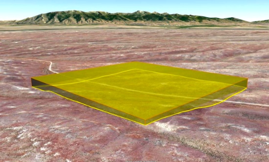
160 Nevada Acres Near Battle Mountain! BIDDING IS PER ACRE!
Quantity: 160
NOTE: Click on the Approximate Coordinates link below to explore the area on Google Maps. Zoom in for a detailed view of local attractions, roads, etc., or zoom out for a wider perspective of the surrounding region.
Parcel ID: 010-080-02
Legal Description: NE4; 26/34N/44E
Acres: 160
State: Nevada
County: Lander
Taxes: Under $20 per month
Approximate Coordinates: 40°47'49.7"N 116°58'48.6"W
BIDDING IS PER ACRE FOR A CASH PURCHASE!
TOTAL BID PRICE = BID PER ACRE x 160 ACRES.
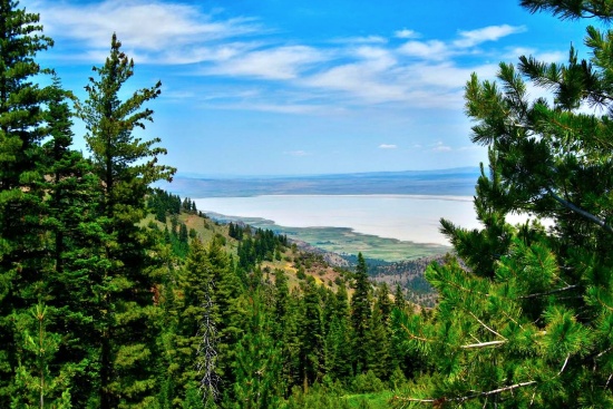
160 Acres of High Mountain Desert Near Battle Mountain, Nevada!
This 160-acre parcel of land is located in the beautiful and rugged terrain of Lander County, Nevada, close to Battle Mountain. The property is situated in an area of natural beauty with rolling hills, expansive views, and abundant wildlife. You get the best of both worlds, in this picturesque mountain valley, close proximity to Crescent Valley which offers diverse attractions and outdoor activities.
The area is renowned for being one of the world's largest gold-producing centers. A river runs through the valley, adding to the scenic beauty of the location.
For those seeking adventure, Lander County offers numerous options, including off-highway vehicle trails, land sailing, fishing, and hunting opportunities. Mountain biking enthusiasts can explore the Copper Basin Mountain Bike Trailhead, while stargazers can enjoy the unobstructed night skies of the high desert. Those looking for relaxation can visit the nearby Spencer Hot Springs and take in the stunning views of the surrounding mountain ranges.
What to Do and See in Lander County >>
The location is perfect for those seeking a remote and peaceful retreat while still being within easy reach of modern amenities. The town of Battle Mountain is just a short drive away, offering a range of shopping, dining, and entertainment options. This friendly community is known for its warm hospitality, stunning natural beauty, and rich cultural heritage.
Video Tour of Battle Mountain, Nevada >>
Outdoor enthusiasts will find plenty to do in the area, with opportunities for hunting, fishing, hiking, and off-road adventures on the nearby trails. The vast, open skies make it an ideal location for stargazing, while the tranquility of the area provides a perfect escape from the hustle and bustle of city life.
This is an excellent opportunity to own a beautiful piece of land in one of the most stunning areas of Nevada!

Invest Now in Valencia County, New Mexico!
NOTE: Click on the Approximate Coordinates link below to explore the area on Google Maps. Zoom in for a detailed view of local attractions, roads, etc., or zoom out for a wider perspective of the surrounding region.
Parcel ID: 1021034495510000000
Legal Description: Subd: RIO DEL ORO Lot: 3-3 Block: 3 Unit: 26 .59 AC 2004 REV
Acre: 0.59
State: New Mexico
County: Valencia
Taxes: Under $5 per month
Approximate Coordinates: 34°45'15.1"N 106°31'17.7"W
This warm-weather location has the country buzzing about it!
July 2024 Update: Approval was recently granted to rezone 268 acres of vacant land, primarily located between NM47 and 304, for manufacturing operations. This bodes well for the continued growth of Valencia County. Development usually breeds development, development brings jobs, and jobs bring people, usually families, who need housing!
Valencia County Welcomes You! >>
Drive the Rio Del Oro Loop! >>
In addition to being rich in culture and a great place to raise a family, Valencia County is experiencing a great deal of economic prosperity. There are so many new and exciting things happening to this already charming location, you cannot miss the chance to buy your land in Valencia County today!
Tens of thousands of new jobs are coming to Los Lunas. Facebook (Meta's) new facility opened in 2019 and continues to grow and generate additional economic benefits to the surrounding areas. The White House recently provided a grant to develop infrastructure for a huge new manufacturing facility. A new rail park is also under development.
Of course, more jobs in this sizzling investment area means greater demand for land.
Facebook (Meta) announces $800M expansion plan for Los Lunas Data Center >>
Once the expansion is completed, the Facebook (Meta) Data Center will employ 400 employees and provide significant economic benefits to the local community.
Facebook (Meta) Los Lunas Data Center and Facebook (Meta) Los Lunas Data Center Drone Video >>
New Facebook (Meta) Data Center + Booming Business in Los Lunas >>
In addition, the Cibola National Forest is just to the east and covers more than 1.6 million acres in New Mexico, with elevations ranging from 2,700 feet to over 11,300 feet. If you and your family enjoy picnicking, backpacking, camping, skiing, hiking, wildlife-viewing, star-gazing, horseback-riding, hunting, or mountain biking, Cibola National Forest has plenty to offer you.
See the beautiful mountains of Valencia County >>
Come see why New Mexico is booming!
NOTE: Back taxes of up to $220 will be the responsibility of the buyer.

Build in this Gof Course Community: Sugar Springs, Michigan!
NOTE: Click on the Approximate Coordinates link below to explore the area on Google Maps. Zoom in for a detailed view of local attractions, roads, etc., or zoom out for a wider perspective of the surrounding region.
Parcel ID: 060-090-000-038-00
Legal Description: 20 1W HIGHLANDER REALM LOT 38
Acre: 0.32
State: Michigan
County: Gladwin
Taxes: Under $15 per month
Approximate Coordinates: 44°08'03.0"N 84°27'04.5"W
Gladwin County is located in the northeast central section of Michigan’s lower peninsula, approximately 2.5 hours from Detroit and a little over 2 hours from Grand Rapids. It is renowned for its warm and welcoming community. You'll find friendly neighbors, local festivals, farmers' markets, and a strong sense of belonging, making it a wonderful place to raise a family or retire.
This prime lot is located on Brassie Court in the Sugar Springs community in Gladwin County. There is paved road frontage, as well as sewer, phone, and electric at the road. It's also just a short drive to Sugar Springs Golf Course, Lake Lancelot and Lake Lancer!
This property is surrounded by the pristine beauty of Butman Township, in Gladwin County, known for its picturesque landscapes, lush forests, and numerous lakes. Living here means waking up to stunning natural views, and with the abundance of year-round recreational outdoor activities, you'll have endless opportunities for adventure and exploration. Whether you're into fishing, hiking, hunting, golfing, or snowmobiling, you are sure to find something you will enjoy.
The nearby lakes, including Lake Lancelot and Lake Lancer, offer a water lover's paradise. These lakes are a great place to enjoy boating, fishing, swimming, and paddleboarding. Fishermen can expect Bluegill, Largemouth Bass, Northern Pike, and Rock Bass among the most popular catches. Whether you want to spend the day going for an exciting jet ski ride or going for a sunset cruise, this is a great place to do so.
Gladwin also offers a variety of fun activities ranging from gorgeous gardens to incredible golf courses. The downtown area features quaint shops, cozy cafes and lovely parks perfect for picnics or leisurely strolls. Sugar Springs Resort has a clubhouse, lounge restaurant, campground, pool, and two golf courses, among other activities.
This prime lot is your gateway to a life filled with natural wonder, outdoor adventures, and endless recreational opportunities, making it an ideal place to call home!
NOTE: The Sugar Springs Property Owners Association (POA) manages this community. The 2025 general assessment fee for this lot is $475, and the lake assessment fee is $60. The buyer will be responsible for all dues beginning on January 1, 2025, as well as a one-time $15 transfer fee upon purchase of the property.

Prime Lot in Philadelphia Metropolitan Area – New Jersey Lot with Nearby Utilities!
NOTE: Click on the Property Address link below to explore the area on Google Maps. Zoom in for a detailed view of local attractions, roads, etc., or zoom out for a wider perspective of the surrounding region.
Parcel ID: 02 00129-0000-00014
Legal Description: Block 129, Lot 14, Deptford Township, Gloucester County
Acre: 0.29
State: New Jersey
County: Gloucester
Taxes: Under $85 per month
Property Address: 806 Buffalo Ct, Deptford, NJ 08096
Gloucester County is part of the Philadelphia metropolitan area. It features a mix of suburban and rural communities, with towns like Woodbury, Deptford, Washington Township, and Glassboro. There are a fascinating array of adventures and unique experiences to uncover in any season of the year!
Sample the local wine at award-winning wineries along the South Jersey wine trail, experience county life on a working dairy farm, or admire the Victorian architecture on a walking tour through many historic downtown districts.
This property is located in Deptford Township, NJ. Deptford has a close-knit community feel with various local events and festivals throughout the year, including holiday parades, community days, and summer concerts. The township has active civic and recreational organizations, such as sports leagues, veterans’ groups, and other community service groups.
Among the many local attractions, put these on your to-do list:
Explore New Jersey's History at Red Bank Battlefield Park: Located on the waterfront of the Delaware River, Red Bank Battlefield played a crucial role in the Revolutionary War.
New Jersey Pinelands National Reserve: Just a short drive away, this protected area offers hiking, biking, and unique ecological experiences.
Deptford Township is situated about 10 miles southeast of Philadelphia. Its proximity to major highways, including Interstate 295 and Route 42, makes it an attractive place for commuters to Philadelphia and other surrounding areas. The township covers around 17.5 square miles, offering a blend of suburban neighborhoods, commercial districts, and recreational amenities.
The Township was officially formed on June 1, 1695, as one of the original townships in Gloucester County, and has a significant connection to American history, as the site of the first hot-air balloon flight in North America in 1793, by Jean-Pierre Blanchard, who launched from Philadelphia and landed in Deptford. Today, it’s a hub for retail and commercial development.
This property is located on Buffalo Court, in the neighborhood of Narraticon. This lot is located within a PUD (Planned Unit Development). Utilities are within about 100 feet of the lot. This is the perfect opportunity to own a lot in a well-established neighborhood, with the added convenience of nearby utilities and easy access to both suburban charm and metropolitan amenities.
Overall, Deptford, NJ, combines the convenience of suburban living with easy access to larger cities and an abundance of local amenities. It is a thriving community known for its history and family-friendly environment.

Buy into Florida's Citrus County!
NOTE: Click on the Approximate Coordinates link below to explore the area on Google Maps. Zoom in for a detailed view of local attractions, roads, etc., or zoom out for a wider perspective of the surrounding region.
Parcel ID: 17E19S220040 01760 0010
Legal Description: UNIT 4 OF HOMOSASSA PB 1 PG 46 LOT 4 BLK 176
Acre: 0.14
State: Florida
County: Citrus
Taxes: Under $5 per month
Approximate Coordinates: 28°48'19.2"N 82°34'03.1"W
Discover the essence of Florida in Citrus County: warm gulf waters, spring-fed rivers, championship golf, unique shops, rich history, and endless aquatic adventure.
A Visit to Citrus County Florida >>
This lot is ideally located in Homosassa Springs, just half a mile east of US 98 (S Suncoast Blvd), with legal access from S. Grandmarch Road to W Grover Cleveland Blvd.
Zoning is Medium Density Residential (MDR) with permissible structures including single family construction, modular housing or tiny homes. Utilities are not available at the lot. Recreational vehicles, tent campsites, and recreational resort cabins may not be used as permanent or long-term residences.
There are plenty of shops, restaurants, and stores nearby! Just a quick five-minute drive to the Homosassa River, where you can enjoy boat tours, waterfront dining, and fishing. Spend your days lounging, swimming, or kayaking under the Florida sun. If you love nature, this is the perfect spot for you!
Go hiking, swim with manatees, birdwatch, and picnic at Ellie Schiller Homosassa Springs Wildlife State Park!
Homosassa Springs State Park >>
Citrus County has it all; place your bid now!

Modoc County, California: 10 Lot Package! BIDDING IS PER LOT!
Quantity: 10
These ten lots are located in the Hill Unit #5 of California Pines, an off-the-grid community located about 30 miles southwest of the one square-mile city of Alturas. The hill units are almost all covered with four different kinds of pine trees. The lots are scattered throughout charming California Pines. While they may not be contiguous, each lot boasts its own unique allure and distinctive dimensions. The elevation in the hill units varies from 5,000 to 6,400 feet. All the roads are gravel roads.
View the 10 lots on a map here! >>
What to Do and See in Modoc County >>
The California Pines Lake is 256 acres and next to it sits the California Pines Lodge, a 4,400 feet airstrip, and campground. The 8,000 square foot lodge features guest rooms, a restaurant, lounge, banquet room and activity room. The grounds of the lodge also include a swimming pool.
See the California Pines Lodge >>
RVs and camping are permissible for up to 30 days of a calendar year.
If you are considering constructing a home, please note that the living space must be no less than 500 square feet.
Construction in the hill units will require a private well and septic system. If there is electricity in the area, it can be extended to your lot. Power is obtained through Surprise Valley Electric. Solar & wind turbine are also allowed.
Development Restrictions for Hill Unit 5 >>
Building in California Pines! >>
The warm, dry summers encourage camping, hiking, fishing, and water sports against the backdrop of the uniquely beautiful Warner Mountains, with their clear alpine streams and a high desert dotted with serene lakes.
The California Pines Property Owners Association maintains common areas for the benefit of the property owners, residents and the general public.
BIDDING IS PER LOT FOR A CASH PURCHASE!
TOTAL BID PRICE = BID PER LOT x 10 LOTS.
NOTE: The California Pines Property Owners Association maintains common areas for the benefit of the property owners, residents and the general public. The 2025 annual POA fee is $105 per lot and will become the responsibility of the buyer.

Explore this 2.5-Acre Oasis in Los Angeles County!
NOTE: Click on the Approximate Coordinates link below to explore the area on Google Maps. Zoom in for a detailed view of local attractions, roads, etc., or zoom out for a wider perspective of the surrounding region.
Parcel ID: 3310016028
Legal Description: TRACT NO 29990 LOT 28
Acres: 2.50
State: California
County: Los Angeles
Taxes: Under $13 per month
Approximate Coordinates: 34°44'35.0"N 117°55'29.0"W
This expansive 2.50-acre parcel sits between 110th Street East and 120th Street East, conveniently situated approximately 15 minutes from renowned attractions such as the Butte Valley Wildflower Sanctuary, Saddleback Butte State Park and Campground, Antelope Valley Indian Museum State Historic Park, and Lake Los Angeles Community. Furthermore, the vibrant city of Lancaster, offering attractions like the Museum of Art and History and the breathtaking Antelope Valley California Poppy Fields, is less than a 30-minute drive away, promising endless opportunities for exploration and leisure.
What To Do in Los Angeles County >>
Explore Saddleback Butte State Park >>
Butte Valley Wildflower Sanctuary >>
Los Angeles County, the most populous county in the United States, boasts nearly 10 million residents across its expansive 4,083 square miles. Remarkably, its population surpasses that of 40 individual U.S. states. Known for its incredible diversity, it stands as one of the most ethnically varied counties in the nation.
Los Angeles County is bisected from west to east by the imposing San Gabriel Mountains, home to many of the county's tallest peaks. Lower mountain ranges dot the northern, western, and southwestern regions, such as the San Emigdio Mountains, the southernmost extension of the Tehachapi Mountains, and the Sierra Pelona Mountains.
The majority of Los Angeles County's population is concentrated in the southern and southwestern regions, where significant population hubs populate the Los Angeles Basin, San Fernando Valley, and San Gabriel Valley.
Act now and secure your slice of paradise! Embrace the warm, sunny climate and indulge in outdoor adventures galore. Don't miss out—this enticing lot is eagerly awaiting its new owner! Place your bid now and make your dreams a reality!

Build in Sharp County, Arkansas!
NOTE: Click on the Approximate Coordinates link below to explore the area on Google Maps. Zoom in for a detailed view of local attractions, roads, etc., or zoom out for a wider perspective of the surrounding region.
Parcel ID: 244-00649-000
Legal Description: Subdivision: CHOCTAW FOURTH Lot: 14 Block: 26
Acre: 0.26
State: Arkansas
County: Sharp
Taxes: Under $12 per month
Approximate Coordinates: 36°16'03.6"N 91°32'37.2"W
Imagine living in this beautiful four seasons serene location in the Arkansas Ozarks!
A home may be constructed on this lot so long as the house size is a minimum of 400 square feet and complies with the zoning set forth in Cherokee Village Zoning "Bill of Assurance": Choctaw Fourth Addition.
Considering retirement, a new start for your family, just ready for a change, or looking for a part-time retreat? Cherokee Village offers small town charm, first-class outdoor recreation amenities and affordability. Take advantage of the low taxes, low cost of living and low housing costs. Your housing dollars stretch further here.
Experience Cherokee Village >>
This lot sits off Tomahawk Drive, a short distance from the Lake Cherokee, South Fork Spring River and a few miles southeast of the Cherokee Village North Golf Course!
Cherokee Village is the perfect backdrop for your next adventure. Come enjoy the lakes, river, golf courses, parks, trails, RV and campground. With more than 13,000 acres set among the rolling hills and pristine natural beauty of the Arkansas Ozarks, Cherokee Village has something to offer all ages.
Soak up the sun on the private beach, hit the links on two private 18-hole golf courses, jump right into any of the six swimming pools, go RVing and camping, take a swing at pickleball and tennis, spend the day fishing, walk any of the nature trails, workout at the fitness center, meet some new friends at the senior center, cycle, hike, or just relax in a hammock!
Boat, fish and play on any of the seven lakes. Enjoy the year-round spring-fed South Fork River that flows into neighboring Spring River. Both rivers rank among the Ozark region’s most popular destinations for floating and trout and walleye fishing.
Seize the opportunity to make this peaceful Arkansas retreat your own and start living the dream in Cherokee Village today!

Explore Gray's Harbor, Washington: Vacant Lot by the River!
NOTE: Click on the Approximate Coordinates link below to explore the area on Google Maps. Zoom in for a detailed view of local attractions, roads, etc., or zoom out for a wider perspective of the surrounding region.
Parcel ID: 729501800100
Legal Description: EAST OCOSTA LOT 3 INC BLK 18
Acre: 0.05
State: Washington
County: Grays Harbor
Taxes: Under $3 per month
Approximate Coordinates: 46°54'06.4"N 124°00'28.9"W
This beautiful county is the Gateway to the Pacific Ocean and Washington's scenic coastal wonderlands! It is located on the southwest corner of the Olympic Peninsula along the Pacific Ocean.
Explore Grays Harbor County >>
This property is located in Ocosta, Washington, a small, coastal community, with several nearby attractions such as the North Bay, John's River, John's River Trail, Wildlife Area, Westport Winery Garden Resort, and more!
Explore Bottle Beach State Park >>
NOTE: You are bidding only on lot 3 outlined in blue.
NOTE: Grays Harbor County has a tendency to change parcel numbers when properties are sold, so please understand that the property purchased will be the same, but the parcel number might change due to the county's accounting method.

Embrace the Opportunity in Valencia County, New Mexico!
NOTE: Click on the Approximate Coordinates link below to explore the area on Google Maps. Zoom in for a detailed view of local attractions, roads, etc., or zoom out for a wider perspective of the surrounding region.
Parcel ID: 1021034090385000460
Legal Description: RIO DEL ORO Lot: 46 Block: 30 Unit: 24 .25 +/- AC
Acre: 0.25
State: New Mexico
County: Valencia
Taxes: Under $5 per month
Approximate Coordinates: 34°44'59.8"N 106°32'05.5"W
This warm-weather location has the country buzzing about it!
July 2024 Update: Approval was recently granted to rezone 268 acres of vacant land, primarily located between NM47 and 304, for manufacturing operations. This bodes well for the continued growth of Valencia County. Development usually breeds development, development brings jobs, and jobs bring people, usually families, who need housing!
Valencia County Welcomes You! >>
Drive the Rio Del Oro Loop! >>
In addition to being rich in culture and a great place to raise a family, Valencia County is experiencing a great deal of economic prosperity. There are so many new and exciting things happening to this already charming location, you cannot miss the chance to buy your land in Valencia County today!
Tens of thousands of new jobs are coming to Los Lunas. Facebook (Meta's) new facility opened in 2019 and continues to grow and generate additional economic benefits to the surrounding areas. The White House recently provided a grant to develop infrastructure for a huge new manufacturing facility. A new rail park is also under development.
Of course, more jobs in this sizzling investment area means greater demand for land.
Facebook (Meta) announces $800M expansion plan for Los Lunas Data Center >>
Once the expansion is completed, the Facebook (Meta) Data Center will employ 400 employees and provide significant economic benefits to the local community.
Facebook (Meta) Los Lunas Data Center and Facebook (Meta) Los Lunas Data Center Drone Video >>
New Facebook (Meta) Data Center + Booming Business in Los Lunas >>
In addition, the Cibola National Forest is just to the east and covers more than 1.6 million acres in New Mexico, with elevations ranging from 2,700 feet to over 11,300 feet. If you and your family enjoy picnicking, backpacking, camping, skiing, hiking, wildlife-viewing, star-gazing, horseback-riding, hunting, or mountain biking, Cibola National Forest has plenty to offer you.
See the beautiful mountains of Valencia County >>
Come see why New Mexico is booming!
NOTE: Back taxes of up to $200 will be the responsibility of the buyer.

Invest in the Ozarks: 20 Buildable Lots in Cherokee Village, AR! BIDDING IS PER LOT!
Quantity: 20
This package of 20 lots is available in Cherokee Village, a beautiful four-seasons serene location in the Arkansas Ozarks! The lots are scattered throughout and are not contiguous.
Cherokee Village is the perfect backdrop for your next adventure. Come enjoy the lakes, river, golf courses, parks, trails, RV and campground. With more than 13,000 acres set among the rolling hills and pristine natural beauty of the Arkansas Ozarks, Cherokee Village has something to offer all ages!
Experience Cherokee Village >>
Cherokee Village Information >>
As the owner of these lots, the possibilities are endless. Hold them as-is as long-term investments. Build to rent or to resell, and so on! This is a great community for a part-time retreat or a full-time residence, for those considering retirement, a new start for their family, or just ready for a change! Cherokee Village offers small town charm, first-class outdoor recreation amenities, and affordability. Take advantage of the low taxes, low cost of living and low housing costs. Your housing dollars stretch further here.
A home may be constructed on these lots as long as the house size is a minimum of 800 square feet (CHOCTAW SECOND, THIRD, or FOURTH ADDITIONS) or 900 square feet (CHOCTAW FIRST ADDITION) and complies with the zoning set forth in Cherokee Village Zoning "Bill of Assurances".
Airbnbs are an acceptable use. In fact, they have some in the community already and the process of registering for the licenses is simple and costs under $40.
Soak up the sun on the private beach, hit the links on two private 18-hole golf courses, jump right into any of the six swimming pools, go RVing and camping, take a swing at pickleball and tennis, spend the day fishing, walk any of the nature trails, workout at the fitness center, meet some new friends at the senior center, cycle, hike, or just relax in a hammock!
Boat, fish and play on any of the seven lakes. Enjoy the year-round spring-fed South Fork River that flows into neighboring Spring River. Both rivers rank among the Ozark region’s most popular destinations for floating and trout and walleye fishing.
Take advantage of this great investment opportunity today!
NOTE: Real estate taxes are current. The buyer will be responsible for all real estate taxes billed on March 1, 2025 that will be due October 15, 2025.
BIDDING IS PER LOT FOR A CASH PURCHASE!
TOTAL BID PRICE = BID PER LOT x 20 LOTS.
Legal Description: See Photo for Legal Descriptions

Cheboygan County, Michigan: Prime Lot by the Golf Course in Wildwood Lakes Community!
NOTE: Click on the Approximate Coordinates link below to explore the area on Google Maps. Zoom in for a detailed view of local attractions, roads, etc., or zoom out for a wider perspective of the surrounding region.
Parcel ID: 251-G01-000-028-00
Legal Description: GOLFVIEW ESTATES SUB, LOT 28. (SEC 21,T33N,R2W) 297/504
Acre: 0.34
State: Michigan
County: Cheboygan
Taxes: Under $8 per month
Approximate Coordinates: 45°14'25.7"N 84°34'03.1"W
Cheboygan County is situated in the northern part of Michigan's Lower Peninsula partly along Lake Huron's shoreline. It is known for its scenic beauty, with a mix of forests, lakes, and rivers allowing ample opportunities for boating, fishing, hiking and hunting.
Area Activities & Attractions! >>
Your Cheboygan County Bucket List! >>
This 0.34 Acre Lot is located on Golfcrest Drive, in the Wildwood Lakes Community in Cheboygan County, Michigan.
The surrounding area features the 227-acre Lake, residential properties, recreational areas, and amenities such as the Wildwood Lakes Golf Course. This 9-hole, par 35 golf course offers a scenic setting for both residents and visitors.
The community is known for its natural beauty, with the lake providing opportunities for fishing, boating, and other water-related activities. The area also offers hiking trails and parks, making it a desirable location for outdoor enthusiasts.
Overall, this peaceful community is enjoyed by residents and visitors alike. There is something here for everyone! Place your bid to become the new owner of this property in this beautiful location!
NOTE: This lot is located in an area where the active Wildwood Valley Property Owners Association exists. Membership is non-mandatory and the buyer can decide to join at any time if they desire. Current Annual dues are $75 and may increase in 2025.

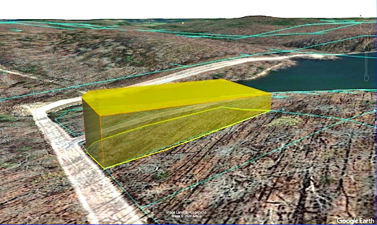
Exclusive Retreat: Secure Your 20 Acres in Lander County, Nevada!
NOTE: Click on the Approximate Coordinates link below to explore the area on Google Maps. Zoom in for a detailed view of local attractions, roads, etc., or zoom out for a wider perspective of the surrounding region.
Parcel ID: 007-650-09
Legal Description: E2NW4SW4 35/30N/47E
Acres: 20
State: Nevada
County: Lander
Taxes: Under $10 per month
Approximate Coordinates: 40°25'35.0"N 116°38'35.9"W
20 Acres of High Desert Land Near Crescent Valley, Nevada!
This 20-acre property lies in the heart of Lander County’s rugged, scenic landscape, close to the majestic Bald Mountain. Nestled in a picturesque mountain valley, the land offers rolling hills, breathtaking views, and abundant wildlife. Its location provides the perfect balance of serene natural beauty with proximity to Crescent Valley and Battle Mountain, where you’ll find a variety of attractions and outdoor activities.
The area is renowned for being one of the world's largest gold-producing centers. A river runs through the valley, adding to the scenic beauty of the location.
For those seeking adventure, Lander County offers numerous options, including off-highway vehicle trails, landsailing, fishing, and hunting opportunities. Mountain biking enthusiasts can explore the Copper Basin Mountain Bike Trailhead, while stargazers can enjoy the unobstructed night skies of the high desert. Those looking for relaxation can visit the nearby Spencer Hot Springs and take in the stunning views of the surrounding mountain ranges.
What to Do and See in Lander County >>
The location is perfect for those seeking a remote and peaceful retreat while still being within easy reach of modern amenities. The town of Battle Mountain is just a short drive away, offering a range of shopping, dining, and entertainment options. This friendly community is known for its warm hospitality, stunning natural beauty, and rich cultural heritage.
Video Tour of Battle Mountain, Nevada >>
Outdoor enthusiasts will find plenty to do in the area, with opportunities for hunting, fishing, hiking, and off-road adventures on the nearby trails. The vast, open skies make it an ideal location for stargazing, while the tranquility of the area provides a perfect escape from the hustle and bustle of city life.
This is an excellent opportunity to own a beautiful piece of land in one of the most stunning areas of Nevada!

Build Your Dream Home on a Half-Acre, Corner Lot in Gladwin County, Michigan!
NOTE: Click on the Approximate Coordinates link below to explore the area on Google Maps. Zoom in for a detailed view of local attractions, roads, etc., or zoom out for a wider perspective of the surrounding region.
Parcel ID: 060-080-000-194-00
Legal Description: 20 1W FAIRFIELD REALM SUB LOT 194
Acre: 0.5
State: Michigan
County: Gladwin
Taxes: Under $20 per month
Approximate Coordinates: 44°07'02.6"N 84°25'15.9"W
Gladwin County is located in the northeast central section of Michigan’s lower peninsula, approximately 2.5 hours from Detroit and a little over 2 hours from Grand Rapids. It is renowned for its warm and welcoming community. You'll find friendly neighbors, local festivals, farmers' markets, and a strong sense of belonging, making it a wonderful place to raise a family or retire.
This prime, buildable, corner lot is located in the desirable Sugar Springs community in Gladwin, offering paved road frontage along with sewer, phone, and electric services right at the road. Enjoy being just a two-minute drive from convenient Lake Lancer boat access!
This property is surrounded by the pristine beauty of Butman Township, in Gladwin County, known for its picturesque landscapes, lush forests, and numerous lakes. Living here means waking up to stunning natural views, and with the abundance of year-round recreational outdoor activities, you'll have endless opportunities for adventure and exploration. Whether you're into fishing, hiking, hunting, golfing, or snowmobiling, you are sure to find something you will enjoy.
The nearby lakes, including Lake Lancelot and Lake Lancer, offer a water lover's paradise. These lakes are a great place to enjoy boating, fishing, swimming, and paddle boarding. Fishermen can expect Bluegill, Largemouth Bass, Northern Pike, and Rock Bass among the most popular catches. Whether you want to spend the day going for an exciting jet ski ride or going for a sunset cruise, this is a great place to do so.
If you’re looking to get further off the lake, the Fruitful Orchid and Cider Mill offers many different events like a fall festival, perfect for the whole family, and the Merry-Hearted Cidery, a sister company, specializes in hard ciders.
Gladwin also offers a variety of fun activities ranging from gorgeous gardens to incredible golf courses. The downtown area features quaint shops, cozy cafes and lovely parks perfect for picnics or leisurely strolls. Sugar Springs Resort has a clubhouse, lounge restaurant, campground, pool, and two golf courses, among other activities.
This prime lot is your gateway to a life filled with natural wonder, outdoor adventures, and endless recreational opportunities, making it an ideal place to call home!
NOTE: The Sugar Springs Property Owners Association (POA) manages this community. The 2024 general assessment fee for this lot is $475, and the lake assessment fee is $60. The buyer will be responsible for all dues beginning on January 1, 2025, as well as a one-time $15 transfer fee upon purchase of the property.

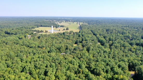
Own Nearly 5 Acres in Historic Navajo County, Arizona!
NOTE: Click on the Approximate Coordinates link below to explore the area on Google Maps. Zoom in for a detailed view of local attractions, roads, etc., or zoom out for a wider perspective of the surrounding region.
Parcel ID: 104-95-031H
Legal Description: Section 21,T19N,R20E: S2 Sw4 Of Tract 48, Pueblo Mesa Ranches Out Of 104-95-031D For2006Roll
Acres: 4.98
State: Navajo
County: Arizona
Taxes: Under $5 per month
Approximate Coordinates: 35°01'32.5"N 110°13'29.0"W
This nearly five-acre parcel is located in Navajo County's Joseph City, a small, historic town located in northern Arizona along the iconic Route 66. Founded in 1876 by Mormon pioneers, it is the oldest Mormon settlement in Arizona that is still in existence. Surrounding this property, there are many attractions such as Lee Mountain, Marcou Mesa, Painted Hills and Minute Co-Sunsky Ranch.
Joseph City has a place in American history as part of the legendary highway. Although it's a small stop, it retains a sense of nostalgia for road trippers exploring the historic route. Also, it’s conveniently located near Interstate 40, making it easy to reach larger cities like Flagstaff (about 90 miles west) and Holbrook (just 12 miles east).
It’s hard to say what takes center stage in Holbrook. It’s a canvas painted with mid-century Route 66 kitsch, Wild West characters, and unforgettable landscapes. Cherished for its roadside Americana charm, Holbrook sits within the Painted Desert, a remarkable area of rocky badlands that stretches from the Grand Canyon to the Navajo Nation. It’s one of Arizona’s most dazzling and lonesome landscapes, with layered bands that change color seemingly every hour.
You can easily get lost in the history, beauty, and culture of this wondrous city. From star gazing, hiking trails, campgrounds, national monuments, historical parks, museums, trading posts, and the Twin Arrows Casino Resort, there is definitely something for everyone!
This parcel is also about an hour drive to the Petrified Forest National Park! In its south, the Rainbow Forest is full of colorful petrified wood. It's home to the Rainbow Forest Museum, with its paleontology exhibits and many trail access points. In the park's center are the petroglyphs of Newspaper Rock and the ruined village of Puerco Pueblo. To the north, the Painted Desert Inn, a 1930s adobe building, is a museum with Hopi murals.
Things To Do: Petrified Forest National Park >>
Own a piece of land that once served one of the greatest Native American tribes, the Navajo Nation. Immerse yourself in the beauty of this one of a kind, diverse culture!

Close to Michigan's Manistee Lake!
NOTE: Click on the Approximate Coordinates link below to explore the area on Google Maps. Zoom in for a detailed view of local attractions, roads, etc., or zoom out for a wider perspective of the surrounding region.
Parcel ID: 005-141-003-00
Legal Description: LOT 5 BLOCK B SECOND ADD TO CHIPPEWA BEACH SEC 35 T28N-R6W
Acre: 0.37
State: Michigan
County: Kalkaska
Taxes: Under $14 per month
Approximate Coordinates: 44°46'32.0"N 85°00'22.7"W
Kalkaska County is a scenic and rural area located in the northern part of Michigan’s Lower Peninsula. Known for its outdoor recreational opportunities, natural beauty, and rich local culture, the county offers a peaceful escape for residents and visitors alike.
The county is characterized by dense forests, rolling hills, and numerous lakes and rivers. It’s part of the northern Michigan landscape, renowned for its pristine natural environments.
One of the county's major natural features, the Manistee River, is a popular destination. The river is known for its clean, clear water and is especially famous for trout fishing.
The county is also home to over 80 inland lakes, including Torch Lake, Starvation Lake, and Bear Lake. These lakes provide ample opportunities for boating, fishing, swimming, and other water-related activities. Sleeping Bear Dunes National Lakeshore is about an hour away.
Kalkaska County has miles of trails that are perfect for hiking, mountain biking, and horseback riding. Many of these trails wind through state forests, offering scenic views and wildlife sightings.
During the winter months, Kalkaska County becomes a haven for snowmobiling enthusiasts. The county has more than 80 miles of groomed snowmobile trails. Cross-country skiing, snowshoeing, and ice fishing are also popular winter activities.
One of the county’s most popular events is the National Trout Festival, which has been held for over 85 years. The festival celebrates the area's fishing heritage, especially its reputation for trout fishing, and includes parades, fishing contests, live entertainment, and a carnival.
Kalkaska County is only about a 25-minute drive from Traverse City, one of Michigan’s top tourist destinations. Traverse City offers shopping, dining, and entertainment, along with its well-known wineries and proximity to Lake Michigan.
Learn More About the County! >>
Overall Kalkaska County, Michigan, is a hidden gem in northern Michigan, offering natural beauty, a welcoming small-town atmosphere, and a wide variety of outdoor activities. With its forests, lakes, and rivers, the county is perfect for those who love fishing, hiking, snowmobiling, and simply enjoying nature. The affordable cost of living, rich history, and close proximity to Traverse City and other northern Michigan destinations make it an attractive place to live, visit, or invest in property. Whether you’re seeking adventure in the great outdoors or looking for a peaceful rural lifestyle, Kalkaska County offers something for everyone.
Build on Eleven Adjacent Lots in Ozark Acres, Arkansas!
NOTE: Click on the Approximate Coordinates link below to explore the area on Google Maps. Zoom in for a detailed view of local attractions, roads, etc., or zoom out for a wider perspective of the surrounding region.
Parcel ID/Legal Description: See Photo for Property Details
Acres: 3.03 Acres in Total
State: Arkansas
County: Sharp
Taxes: Under $110 per month
Approximate Coordinates: 36°18'15.2"N 91°23'30.2"W
Welcome to the enchanting community of Ozark Acres, surrounded by beautiful lakes, rivers and rolling hills! Ozark Acres is surrounded on all sides by thousands of acres of virgin timberland in which wildlife of many kinds can be observed purely for enjoyment or hunting.
A residential structure may be constructed on these lots as long as the house sizes are a minimum of 500 square feet and complies with the zoning set forth in the Ozark Acres Bill of Assurance. Highland Addition
Escape the hustle and bustle of urban life and immerse yourself in the serene beauty in harmony with nature. The natural beauty surrounding the property is truly captivating, featuring lush greenery, gentle rolling hills, and a diverse array of wildlife. Nature enthusiasts and outdoor lovers will relish in the abundant recreational opportunities, from hiking trails to fishing spots and nearby lakes for water sports. The community contains multiple parks, two lakes, as well as a beach with great views of the larger Lake Vagabond. And the Spring River is only a few miles away!
The Clubhouse conducts many activities throughout the year, as well as group activities monthly.
The quaint town of Hardy built on the banks of the Spring River, a popular tourist spot since the early 1900’s is only six miles from Ozark Acres. This is an ideal location for having the best of both worlds…far enough from larger towns to enjoy the quaint rural living but close enough for additional conveniences.
The Spring River is a couple of miles from Ozark Acres. The river itself is formed from the enormous Mammoth Spring, located within a stone’s throw from Hardy. The Spring River is a great trout fishing spot, it’s a VERY popular floating and party river in the warmer swimming months. It’s stocked by a nearby hatchery, so the locals freely come and usually keep their catch. The river is crystal-clear, with long pools and whitewater falls. The scenery is mostly hardwood forest with some rocky bluffs. Access is from U.S. 63, which parallels much of the river.
Whether you're seeking a peaceful retreat or a solid investment opportunity, these properties in Ozark Acres promises to fulfill your desires. Escape the hustle and bustle of urban life and immerse yourself in the serene beauty of Sharp County, Arkansas. Embrace the chance to build the haven you've always envisioned and relish the simple joys of a life well-lived in harmony with nature.
NOTE: Real estate taxes are current. The buyer will be responsible for all real estate taxes billed on March 1, 2025 that will be due October 15, 2025.

Michigan's Upper Peninsula: Lot Near the Menominee River!
NOTE: Click on the Approximate Coordinates link below to explore the area on Google Maps. Zoom in for a detailed view of local attractions, roads, etc., or zoom out for a wider perspective of the surrounding region.
Parcel ID: 002-481-012-00
Legal Description: LOT 12 BLK 1. FIRST ADD TO EAST BREITUNG.
Acre: 0.29
State: Michigan
County: Dickinson
Taxes: Under $8 per month
Approximate Coordinates: 45°47'22.4"N 88°03'26.7"W
If you are looking for an adventure, you can certainly find it in Michigan’s Upper Peninsula! Besides thrilling wilderness adventures, you can also enjoy natural serenity, historical attractions, and four-season beauty.
Michigan's Upper Peninsula! >>
This prime wooded lot is conveniently located in Kingsford within Dickinson County, in Michigan’s western Upper Peninsula bordering the Menominee River that serves as the state line between Michigan and Wisconsin.
Shoot down the region’s most intense rapids or see some of the country’s best athletes prepare for the Olympics!
Explore the UP Shore - Dickinson County >>
This lot is within a 15-minute drive of Fumee Lake, Pine Mountain Ski & Golf Resort, and the Golf Digest top-rated golfing destination, Timberstone, where golf and nature come together!
Enjoy horseback riding, cross country skiing, biking, hiking, bird watching, canoeing, kayaking, whitewater rafting, rock climbing, golf, fishing, snowmobiles, fascinating history attractions, craft beers and more!
Lots to Do in Dickinson County >>
Thrill seekers can shoot down the region’s most intense whitewater rafting through Piers Gorge on the Menominee River, the only Class IV rapids in the Midwest.
Whitewater Rafting in the Menominee River >>
Experience Whitewater Rafting >>
For a more relaxing time, canoe, kayak or fish on rivers or inland lakes across the county.
Take a historic journey and go back in time to visit the WWII Glider & Military Museum and learn the Ford plant in Kingsford being converted to make wooden gliders to fly reconnaissance missions over the English Channel.
In winter, visit the giant Pine Mountain Ski Jump in nearby Iron Mountain, the largest ski jumping facility in North America. You can ski the Pine Mountain ski area or its lit cross-country trails. For motorized fun, snowmobile on 120 miles of trails.
Dickinson County offers non-stop activities to please everyone! Bid today!
Invest in 40 Acres of Nevada Wilderness!
NOTE: Click on the Approximate Coordinates link below to explore the area on Google Maps. Zoom in for a detailed view of local attractions, roads, etc., or zoom out for a wider perspective of the surrounding region.
Parcel ID: 007-13G-001
Legal Description: SE4NE4; TOWNSHIP 38 NORTH, RANGE 58 EAST, MDB&M SECTION 25
Acres: 40
State: Nevada
County: Elko
Taxes: Under $5 per month
Approximate Coordinates: 41°09'13.0"N 115°22'20.0"W
Elko County, in northeast Nevada, brings the drama of the high desert into vivid reality with its unspoiled nature, breathtaking vistas of the ruggedly beautiful Ruby Mountains, and its rich western history.
There are no shortages of activities to enjoy here: trips up Lamoille Canyon, boating or bird-watching at the Ruby Lake National Wildlife Refuge, down-and-dirty ATVing, out-of-this-world heli-skiing, rock climbing, mountain biking, hunting, fishing, backpacking, or hiking the rocky trails.
The city of Elko, the county seat, is known as "Nevada with Altitude". It is bordered by the towering, snow-capped Ruby Mountains, often called the Alps of Nevada, and the lush, glacier-carved Lamoille Canyon. The Ruby Mountains are flush with wildlife, mountain scenery, lakes, streams, and valleys.
Elko is where Nevada's real cowboys work and play, and the Wild West spirit is contagious. Elko is ranked as one of the Top True Western Towns, but the events in Elko go beyond its western roots. Every July is the annual National Basque Festival, a nod to the rich Basque history and culture that brought sheepherding to the area.
Today, visitors to Elko can explore Nevada's roots in mining, ranching, and native culture with a stop at the Northeastern Nevada Museum, Western Folklife Center, or the Sherman Station Visitor's Center. Don't forget to take a tour to see firsthand one of the area's many gold rush ghost towns.
View this Elko County Video >>
Learn about the history of Elko County >>
This is an excellent opportunity to own a beautiful piece of land in one of the most stunning areas of Nevada!

Own Land in Florida: 1.27 Acre Wooded Lot!
NOTE: Click on the Approximate Coordinates link below to explore the area on Google Maps. Zoom in for a detailed view of local attractions, roads, etc., or zoom out for a wider perspective of the surrounding region.
Parcel ID: 313135000000032110
Legal Description: W1/2 OF SE1/4 OF SW1/4 OF SE1/4 OF NW1/4 LESS 1/2; INT IN OIL GAS AND MINERAL RIGHTS
Acres: 1.27
State: Florida
County: Polk
Taxes: Under $2 per month
Approximate Coordinates: 27°44'21.5"N 81°11'49.4"W
Here is your chance to own a piece of Florida!
This 1.27 acre plat of land is located in a peaceful, wooded area in southeastern Polk County, surrounded by Lakes Kissimmee, Weohyakapka, and Arbuckle, among others. It is located about 85 miles south of Orlando and 90 miles east of Tampa.
This parcel does not have frontage on a county maintained road. For this reason, the starting bid is deeply discounted, enhancing the attractiveness of this parcel as a long term investment.
With over 2,000 square miles of land and water, Polk County is Florida’s fourth largest county. Polk County is located in the geographic center of Florida and along Central Florida’s I-4 corridor.
Florida has surpassed New York as the third-largest state in terms of population, going from 18,801,310 residents in 2010 to 22,359,251 (and counting) in 2023. This growth pushes up demand for land needed for additional housing, facilities to serve the growing population, and so on!
See why Polk County is one of the fastest growing counties! >>
With millions of visitors each year to its beaches, major amusement parks centered around Orlando and cruise ships departing from ports on both coasts, tourism is a major contributor to Florida's robust economy.
Purchasing this piece of Florida will diversify your investment portfolio, don’t miss this opportunity!
NOTE: Polk County does not permit living in RVs at any time.
NOTE: This property is located in the vicinity of the Avon Park Air Force Range Military Training Facility and may be subject to potential day and night low level aircraft overflight and military training noise during training exercises.

Van Buren County, Michigan: Over-an-Acre Corner Lot!
NOTE: Click on the Approximate Coordinates link below to explore the area on Google Maps. Zoom in for a detailed view of local attractions, roads, etc., or zoom out for a wider perspective of the surrounding region.
Parcel ID: 80-54-407-063-00
Legal Description: A-567 7-2-15 453-285 502-302 962-461 1542-139 1585-709 1591-703 1702-418 * BEG AT NW COR OF SEC, TH S ALG W SEC L TO CEN L CEMETERY RD, TH ELY ALG SD CEN L TO N SEC L, TH W ALG SD SEC L TO HIGH WATER L OR MILL POND, TH WLY ALG SD HIGH WATER L TO N SEC L, TH W ALG SD SEC L TO BEG. EX CENTER ST AND CEMETERY RD R.O.W. UNPLATTED.
Acres: 1.14
State: Michigan
County: Van Buren
Taxes: Under $34 per month
Approximate Coordinates: 42°18'55.1"N 86°06'31.8"W
This property is located in Van Buren County, Michigan, on the corner of Richard Beer Memorial Dr and N Center Street!
Van Buren County, Michigan is located in the southwestern part of the state, along the eastern shore of Lake Michigan. It is part of the broader Kalamazoo-Portage metropolitan area. Established in 1829, the county was named after Martin Van Buren, who was then serving as Secretary of State and later became the 8th President of the United States.
The County offers lush nature trails, gorgeous golf courses, and stunning inland lakes. Just a short drive away is the popular beach and harbor town of South Haven, with its iconic lighthouse, Michigan Maritime Museum, and quaint downtown.
Plenty to do in Van Buren County >>
Overall, Van Buren County is a picturesque, largely rural area with a thriving agricultural sector, beautiful lakes and beaches, and a tourism industry that peaks in the summer months due to its proximity to Lake Michigan.
Walking Distance to Arkansas' Vagabond Lake!
NOTE: Click on the Approximate Coordinates link below to explore the area on Google Maps. Zoom in for a detailed view of local attractions, roads, etc., or zoom out for a wider perspective of the surrounding region.
Parcel ID: 502-00033-000
Legal Description: Subdivision: VAGABOND HEIGHTS Lot: 1 Block: 2
Acre: 0.29
State: Arkansas
County: Sharp
Taxes: Under $8 per month
Approximate Coordinates: 36°17'21.0"N 91°22'17.6"W
Discover a wonderful opportunity to own a picturesque buildable lot in the enchanting community of Ozark Acres, located in the heart of Sharp County, Arkansas. Nestled amidst the beauty of the Ozarks, this property offers an idyllic setting for creating your dream retreat or permanent residence.
This prime, buildable, corner lot is located on Vagabond Trail, walking distance to Vagabond Lake! A residential structure may be constructed on this lot as long as the house size complies with the zoning set forth in the Ozark Acres Bill of Assurance: Vagabond Heights Addition.
Set within a friendly and well-established neighborhood, this location provides the perfect blend of rural tranquility and easy access to modern conveniences. With ample space to accommodate your vision, you can design your ideal home, whether it be a cozy cabin or a spacious abode.
The natural beauty surrounding the property is truly captivating, featuring lush greenery, gentle rolling hills, and a diverse array of wildlife. Nature enthusiasts and outdoor lovers will relish in the abundant recreational opportunities, from hiking trails to fishing spots and nearby lakes for water sports.
Whether you're seeking a peaceful retreat or a solid investment opportunity, this property in Ozark Acres promises to fulfill your desires. Escape the hustle and bustle of urban life and immerse yourself in the serene beauty of Sharp County, Arkansas. Embrace the chance to build the haven you've always envisioned and relish the simple joys of a life well-lived in harmony with nature.
NOTE: Real estate taxes are current. The buyer will be responsible for all real estate taxes billed on March 1, 2025 that will be due October 15, 2025.
