Find Stability in Land Investments!
Find Stability in Land Investments!
See Special Terms for additional fees
Description


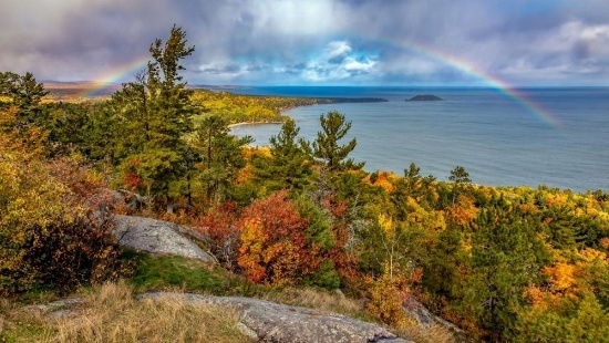
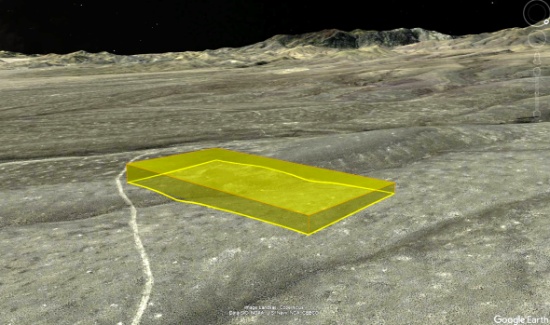
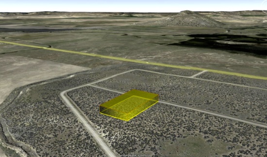
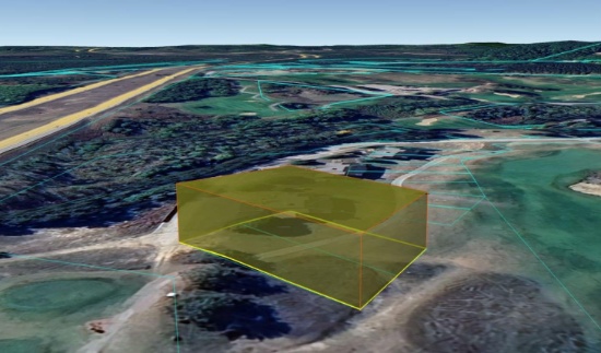
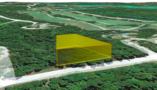
Your Future Homesite in Georgia Awaits!
NOTE: Click on the Property Address link below to explore the area on Google Maps. Zoom in for a detailed view of local attractions, roads, etc., or zoom out for a wider perspective of the surrounding region.
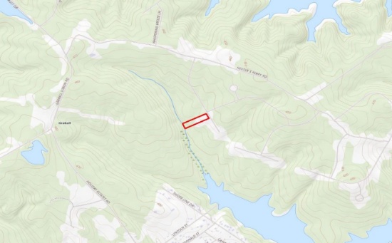
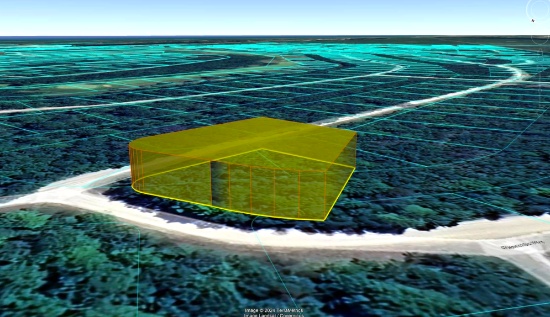
Parcel ID: 0010A-00000-306-000
Legal Description: Lot 306 Phase II Stillwater Coves
Acres: 2.13
State: Georgia
County: Lincoln
Taxes: Under $55 per year
Property Address: 1166 Hardwood Dr, Tignall, GA 30668
Build your new home on this 2.13 acre property in Stillwater Coves, Lincoln County, Georgia!
Lincoln County is a small, rural county located in the eastern Piedmont region of Georgia, very close to the South Carolina border. It is situated along the western shore of the Clarks Hill Lake, also known as Lake Thurmond. Lincoln County is known for its tight-knit community, southern hospitality, and small-town charm.
This beautiful property is located in Stillwater Coves, a residential community located in Tignall, on the shores of Lake Thurmond. Tignall embodies the small-town atmosphere, with a strong sense of community, traditional values, and a slower pace of life. The proximity to historical sites and the natural beauty of the region offer potential for tourism, particularly for those interested in Georgia’s history or seeking a peaceful rural getaway.
Residents enjoy easy access to boating, fishing, kayaking, and other water sports. The area offers scenic views, outdoor recreational activities, and a tranquil lifestyle, making it appealing for those seeking a lakeside or countryside retreat.
Experience the Georgia River Trails >>
Planned amenities for the community include a landscaped entry way, easy access day docks, boat storage, pool with bath house, walking trails, and a community pavilion complete with a summer kitchen, open fireplace, and a picnic area.
Stillwater Coves' community theme is a neighborhood of Southern summer homes that have a look and feel of the houses reminiscent of early 20th century retreats in the South.
All site work, structures and landscaping are subject to design and aesthetics approval that meet the community’s Design Review Guidelines, Style Book and Covenants (available upon request).
Homes must have a minimum of 1,300 SF of heated space on the main level and a maximum of 5,800 SF in total. All utilities (water, sewer and electricity) are at the curb for home construction.
Besides lake activities, the area around Stillwater Coves offers parks, hiking trails, wildlife management areas and campgrounds, including the popular, nearby campground, Hester's Ferry.
Georgia Freshwater Camping - Hesters Ferry >>
The Richard B. Russell State Park and Clarks Hill Wildlife Management Area are also popular destinations for outdoor enthusiasts.
Explore Richard B. Russell State Park >>
Overall, Stillwater Coves provides a peaceful, nature-oriented lifestyle, perfect for those who enjoy lakeside living in a quiet, rural setting.
Claim this prime property today!
NOTE: This property is located within the Stillwater Coves HOA, managed by Silverleaf Management Company. The annual dues of $700.00 were paid in full in December 2024. Buyer will be responsible for 2025 dues and a $109 initiation fee.
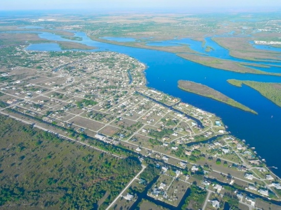
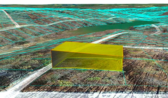
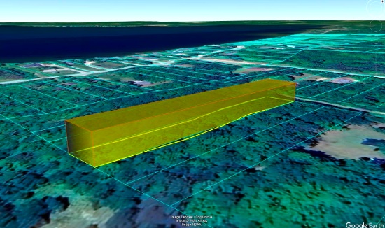
Live in Harbour Heights, Charlotte County, Florida!
NOTE: Click on the Property Address link below to explore the area on Google Maps. Zoom in for a detailed view of local attractions, roads, etc., or zoom out for a wider perspective of the surrounding region.
Parcel ID: 402315103006
Legal Description: HRBR HTS SEC 6 BLK 120 LTS 33 & 34 1345/327 1419/63
Acre: 0.23
State: Florida
County: Charlotte
Taxes: Under $55 per month
Property Address: 2082 Highlands Rd, Punta Gorda, FL 33983
Located in Charlotte County, Florida, Harbour Heights is an unincorporated waterfront community situated along the scenic Peace River. It offers a laid-back, residential atmosphere with a focus on outdoor activities, especially boating and fishing, making it attractive to retirees, seasonal residents, and families seeking a peaceful lifestyle.
Port Charlotte, FL Video Tour: Affordable Resort - Town Living! >>
This pair of adjacent, buildable lots is situated just off Highlands Road. It is about a mile from Whidden Bay, a small bay located off the Peace River.
While Harbour Heights is primarily residential, nearby Punta Gorda and Port Charlotte provide access to more extensive shopping, dining, and healthcare services. The area is quiet, and the community tends to be close-knit, with an emphasis on outdoor living.
Harbour Heights shares the typical warm, subtropical climate of Southwest Florida, with hot summers and mild winters. It’s ideal for outdoor activities year-round.
This property is just a short drive to many attractions, such as Deep Creek Golf Club, Peace River, Port Charlotte, and Port Charlotte Beach Park.
Experience a Florida Camping and Canoe Adventure on the Peace River! >>
The peaceful atmosphere makes it a perfect place for anyone looking for a tranquil and relaxing retreat. Come and explore all that Charlotte County has to offer!
NOTE: County does not permit living in RVs at any time unless a house has been constructed on the lot.
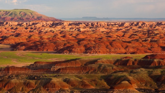
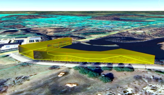
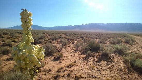
76 Acres in Navajo County, Arizona!
Quantity: 76
NOTE: Click on the Approximate Coordinates link below to explore the area on Google Maps. Zoom in for a detailed view of local attractions, roads, etc., or zoom out for a wider perspective of the surrounding region.
Parcel ID: 106-12-012
Legal Description: Section 12,T18N,R23E:S2 Se4Less Rr R/W & Water LineEasement
Acres: 76
State: Arizona
County: Navajo
Taxes: Under $10 per month
Approximate Coordinates: 34°58'11.7"N 109°50'54.1"W
This sprawling 76-acre property sits on the edge of Petrified Forest National Park in Navajo County, Arizona. Tucked away in the wide-open desert, this land offers unmatched seclusion, raw natural beauty, and a direct connection to one of the most unique landscapes in the country.
Located just east of Joseph City and about 12 miles from Holbrook, this parcel places you right along the southern border of Petrified Forest National Park. The park is known for its colorful petrified wood, sweeping badlands, ancient petroglyphs, and deep cultural history. From this land, you can explore nearby features like the Rainbow Forest Museum, Newspaper Rock, Puerco Pueblo ruins, and the iconic Painted Desert — all just a short drive away.
The nearby town of Holbrook brings mid-century Route 66 charm, local shops, and essentials — while Flagstaff, about 90 miles west, offers a larger city experience. You also have close access to Interstate 40, making travel in either direction easy and convenient.
This property borders land once inhabited by the Navajo Nation, rich in culture and stories. Whether you're looking to invest, build off-grid, or simply own a piece of Arizona’s timeless desert, this is a rare chance to stake your claim right next to a national park.
Things To Do: Petrified Forest National Park >>
Own a piece of land that once served one of the greatest Native American tribes, the Navajo Nation. Immerse yourself in the beauty of this one of a kind, diverse culture!
Investment Deal: 20 Serene Acres in Lander County, Nevada!
NOTE: Click on the Approximate Coordinates link below to explore the area on Google Maps. Zoom in for a detailed view of local attractions, roads, etc., or zoom out for a wider perspective of the surrounding region.
Parcel ID: 007-650-09
Legal Description: E2NW4SW4 35/30N/47E
Acres: 20
State: Nevada
County: Lander
Taxes: Under $10 per month
Approximate Coordinates: 40°25'35.0"N 116°38'35.9"W
20 Acres of High Desert Land Near Crescent Valley, Nevada!
This 20-acre property lies in the heart of Lander County’s rugged, scenic landscape, close to the majestic Bald Mountain. Nestled in a picturesque mountain valley, the land offers rolling hills, breathtaking views, and abundant wildlife. Its location provides the perfect balance of serene natural beauty with proximity to Crescent Valley and Battle Mountain, where you’ll find a variety of attractions and outdoor activities.
The area is renowned for being one of the world's largest gold-producing centers. A river runs through the valley, adding to the scenic beauty of the location.
For those seeking adventure, Lander County offers numerous options, including off-highway vehicle trails, landsailing, fishing, and hunting opportunities. Mountain biking enthusiasts can explore the Copper Basin Mountain Bike Trailhead, while stargazers can enjoy the unobstructed night skies of the high desert. Those looking for relaxation can visit the nearby Spencer Hot Springs and take in the stunning views of the surrounding mountain ranges.
What to Do and See in Lander County >>
The location is perfect for those seeking a remote and peaceful retreat while still being within easy reach of modern amenities. The town of Battle Mountain is just a short drive away, offering a range of shopping, dining, and entertainment options. This friendly community is known for its warm hospitality, stunning natural beauty, and rich cultural heritage.
Video Tour of Battle Mountain, Nevada >>
Outdoor enthusiasts will find plenty to do in the area, with opportunities for hunting, fishing, hiking, and off-road adventures on the nearby trails. The vast, open skies make it an ideal location for stargazing, while the tranquility of the area provides a perfect escape from the hustle and bustle of city life.
This is an excellent opportunity to own a beautiful piece of land in one of the most stunning areas of Nevada!
Short Walk to Spring Lake: Ozark Acres, Arkansas!
NOTE: Click on the Approximate Coordinates link below to explore the area on Google Maps. Zoom in for a detailed view of local attractions, roads, etc., or zoom out for a wider perspective of the surrounding region.
Parcel ID: 514-00041-000
Legal Description: Subdivision: WEST LAKE ADDN Lot: 22 Block: 2
Acre: 0.24
State: Arkansas
County: Sharp
Taxes: Under $8 per month
Approximate Coordinates: 36°18'09.7"N 91°23'44.3"W
Discover a wonderful opportunity to own a picturesque buildable lot in the enchanting community of Ozark Acres, located in the heart of Sharp County, Arkansas. Nestled amidst the beauty of the Ozarks, this property offers an idyllic setting for creating your dream retreat or permanent residence.
Ozark Acres is surrounded on all sides by thousands of acres of virgin timberland in which wildlife of many kinds can be observed purely for enjoyment or hunting.
It is an unincorporated community governed under a Suburban Improvement District (SID) with benefits similar to HOA communities but without the fees!
This prime, buildable, corner lot is located on West Lakeshore Drive, walking distance to Spring Lake! A residential structure may be constructed on this lot as long as the house size complies with the zoning set forth in the Ozark Acres Bill of Assurance: West Lake Addition.
Set within a friendly and well-established neighborhood, this location provides the perfect blend of rural tranquility and easy access to modern conveniences. With ample space to accommodate your vision, you can design your ideal home, whether it be a cozy cabin or a spacious abode.
The natural beauty surrounding the property is truly captivating, featuring lush greenery, gentle rolling hills, and a diverse array of wildlife. Nature enthusiasts and outdoor lovers will relish in the abundant recreational opportunities, from hiking trails to fishing spots and nearby lakes for water sports.
Whether you're seeking a peaceful retreat or a solid investment opportunity, this property in Ozark Acres promises to fulfill your desires. Escape the hustle and bustle of urban life and immerse yourself in the serene beauty of Sharp County, Arkansas. Embrace the chance to build the haven you've always envisioned and relish the simple joys of a life well-lived in harmony with nature.
NOTE: Real estate taxes are current. The buyer will be responsible for all real estate taxes billed on March 1, 2025 that will be due October 15, 2025.
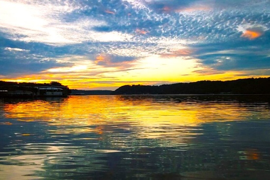
Over an Acre by the River in Van Buren County, Michigan!
NOTE: Click on the Approximate Coordinates link below to explore the area on Google Maps. Zoom in for a detailed view of local attractions, roads, etc., or zoom out for a wider perspective of the surrounding region.
Parcel ID: 80-54-407-063-00
Legal Description: A-567 7-2-15 453-285 502-302 962-461 1542-139 1585-709 1591-703 1702-418 * BEG AT NW COR OF SEC, TH S ALG W SEC L TO CEN L CEMETERY RD, TH ELY ALG SD CEN L TO N SEC L, TH W ALG SD SEC L TO HIGH WATER L OR MILL POND, TH WLY ALG SD HIGH WATER L TO N SEC L, TH W ALG SD SEC L TO BEG. EX CENTER ST AND CEMETERY RD R.O.W. UNPLATTED.
Acres: 1.14
State: Michigan
County: Van Buren
Taxes: Under $34 per month
Approximate Coordinates: 42°18'55.1"N 86°06'31.8"W
This property is located in Van Buren County, Michigan, on the corner of Richard Beer Memorial Dr and N Center Street!
Van Buren County, Michigan is located in the southwestern part of the state, along the eastern shore of Lake Michigan. It is part of the broader Kalamazoo-Portage metropolitan area. Established in 1829, the county was named after Martin Van Buren, who was then serving as Secretary of State and later became the 8th President of the United States.
The County offers lush nature trails, gorgeous golf courses, and stunning inland lakes. Just a short drive away is the popular beach and harbor town of South Haven, with its iconic lighthouse, Michigan Maritime Museum, and quaint downtown.
Plenty to do in Van Buren County >>
Overall, Van Buren County is a picturesque, largely rural area with a thriving agricultural sector, beautiful lakes and beaches, and a tourism industry that peaks in the summer months due to its proximity to Lake Michigan.
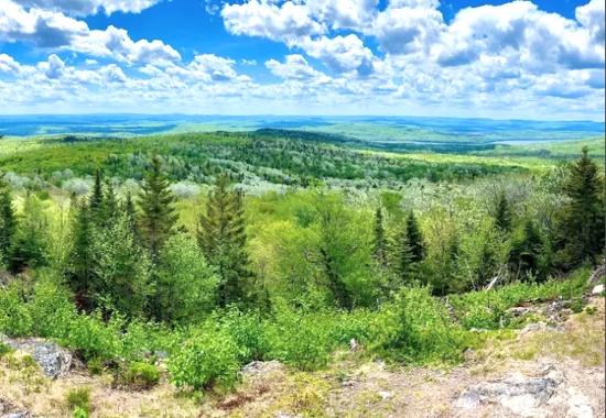
43 Acres in Maine!
NOTE: Click on the Approximate Coordinates link below to explore the area on Google Maps. Zoom in for a detailed view of local attractions, roads, etc., or zoom out for a wider perspective of the surrounding region.
Acres: 43.10
State: Maine
County: Aroostook
Taxes: Under $30 per year
Approximate Coordinates: 47°01'12.7"N 68°03'45.7"W
This 43-acre property is located off Stockholm Road, in New Sweden, Maine.
Whether you’re seeking a peaceful retreat or access to abundant outdoor recreational activities, this property provides the perfect balance of tranquility and adventure. It is a popular destination for outdoor recreational activities, including fishing, boating, and swimming during the summer months. In the winter, the lake attracts ice fishermen and snowmobilers who take advantage of the frozen surface. The area's picturesque landscape, characterized by rolling hills, forests, and the pristine lake, offers a serene and tranquil environment.
Aroostook County is the northernmost region and the largest county in wild, rugged, and deeply beautiful Maine. The state is 90 percent forest, with a coastline that, if stretched out, would reach to California. Enjoy amenities that are every bit present-day, while exploring quaint villages and years-old cultures that make it seem as if you have stepped back in time.
Welcome to Aroostook County >>
Things to Do, Places to Go in Aroostook >>
Overall, Maine, provides a scenic retreat for those seeking a peaceful environment and outdoor recreational activities. Its location in Aroostook County offers a taste of rural life in northern Maine, with access to stunning natural beauty and a close-knit community. Bid today!

Buildable Lot in Beautiful Canadian Lakes, Michigan!
NOTE: Click on the Approximate Coordinates link below to explore the area on Google Maps. Zoom in for a detailed view of local attractions, roads, etc., or zoom out for a wider perspective of the surrounding region.
Parcel ID: 11 186 027 000
Legal Description: SEC 29 T14N R08W LOT 27 CANADIAN LAKES PINES #1
Acre: 0.41
State: Michigan
County: Mecosta
Taxes: Under $3 per month
Approximate Coordinates: 43°34'41.0"N 85°17'21.5"W
Build your dream home with road frontage close to the golf course in Canadian Lakes, a private recreational community in northern Michigan.
Are you ready to live your GOOD LIFE?
Owners have inclusive use of remarkable amenities, including over 730 acres of waterways for all types of water sports, six beaches, sports venues, two 9-hole and one 18-hole golf courses, outdoor and indoor swimming pools, fitness area, hot tub, sauna, snow tubing tow, cross-country skiing, outdoor ice rink, campground, and more!
Canadian Lakes is located in Mecosta County, truly "The County for Every Season!" Escape for an afternoon excursion in the county.
Explore the Big Rapids Region >>
Explore numerous trails for hiking and biking, snowshoeing or snowmobiling, or enjoy the abundant land and lakes for hunting and fishing. Enjoy over 100 lakes and streams and, of course, the mighty Muskegon River. All are perfect for fishing, tubing, canoeing, kayaking, boating, and water-skiing.
Take in the wonder of wildlife and scenic views. You'll be surrounded by numerous festivals, events, and unique hometown shops. Excite your taste buds at nearby tasty dining venues, breweries, and wineries.
Don't miss this GOOD LIFE!!
NOTE: The Canadian Lakes Property Owners Corporation (POC) manages this community. The annual fee for 2025 is $870.84. The buyer, upon purchase, is responsible for directly paying all outstanding fees up to $2,200 to the POC.
NOTE: To maintain this beautiful community, Canadian Lakes requires owners to obtain the prior written approval of the Architectural Control Committee (ACC) for any exterior alteration or addition to the property. Deed Restrictions and the application forms for ACC approval are available upon request.
Live in Peaceful California Pines Community, Modoc County, California!
NOTE: Click on the Approximate Coordinates link below to explore the area on Google Maps. Zoom in for a detailed view of local attractions, roads, etc., or zoom out for a wider perspective of the surrounding region.
Parcel ID: 036-013-009-000
Legal Description: Lot 3, Block 6, California Pines Unit Lake 1-A, a subdivision of the County of Modoc according to the official Plat thereof, filed in Book 2 of Maps in Modoc County Records.
Acres: 0.91
State: Modoc
County: California
Taxes: Under $28 per month
Approximate Coordinates: 41°25'07.7"N 120°43'09.9"W
Nestled in the northeastern corner of California, Modoc County is a tranquil and picturesque haven filled with untouched natural beauty and a laid-back, small-town charm. Blessed with breathtaking landscapes, this county boasts rolling meadows, pristine lakes, and towering mountains, offering outdoor enthusiasts a playground for hiking, hunting, fishing, and wildlife observation.
The Modoc National Forest, Tule Lake National Wildlife Refuge, Lava Beds National Monument, Bly Tunnel Tree, Glass Mountain, Medicine Lake, and Lassen Volcanic National Park are among the region's popular destinations for outdoor enthusiasts. Take advantage of the recreational opportunities of the Modoc National Wildlife Refuge near Alturas in the high desert country of northeastern California.
Modoc County's unspoiled beauty invites you to explore and discover hidden gems. Whether you're interested in photography, geology, or history, there's always something new to uncover in the region.
Welcome to Modoc County, California >>
This nearly an acre lot is located in Unit 1-A of the Lake District of California Pines, a beautiful community located about 12 miles southwest of the City of Alturas in Modoc County. California Pines covers 15,000 acres surrounded by 2 million acres of the Modoc National Forest. It is a place where you will find a close-knit community that fosters a strong sense of belonging and a serene lifestyle, free from the hustle and bustle of urban centers.
The Lake Units are located at an elevation of 4,300 feet in mostly meadow pasture land type of property, with scattered juniper trees and sagebrush. The California Pines Lake is 256 acres and next to it sits the California Pines Lodge, a 4,400 feet airstrip, and campground. The 8,000 square foot lodge features guest rooms, a restaurant, lounge, banquet room and activity room. The grounds of the lodge also include a swimming pool.
See the California Pines Lodge >>
RVs and camping are permissible for up to 30 days of a calendar year. If you are considering constructing a home, please note that the living space must be no less than 1,000 square feet, you must drill a well and install a septic system, and you can extend electric lines or install solar power. Please review the following link below for detailed information.
Don’t let this opportunity pass you by!!
NOTE: The annual POA fee is $105 and will become the responsibility of the buyer.
Invest in Valencia County, New Mexico!
NOTE: Click on the Approximate Coordinates link below to explore the area on Google Maps. Zoom in for a detailed view of local attractions, roads, etc., or zoom out for a wider perspective of the surrounding region.
Parcel ID: 1022034195425000000
Legal Description: Subd: RIO DEL ORO Lot: 28-1 Block: 28 Unit: 26 .50 AC 2004 REV
Acre: 0.50
State: New Mexico
County: Valencia
Taxes: Under $5 per month
Approximate Coordinates: 34°45'09.9"N 106°30'50.3"W
Valencia County Welcomes You! >>
Enjoy all that New Mexico has to offer: the great outdoors and economic development! This half-acre lot is close to Monterey Boulevard, which connects to the Rio Del Oro Loop!
Drive the Rio Del Oro Loop! >>
July 2024 Update: Approval was recently granted to rezone 268 acres of vacant land, primarily located between NM47 and 304, for manufacturing operations. This bodes well for the continued growth of Valencia County. Development usually breeds development, development brings jobs, and jobs bring people, usually families, who need housing!
Tens of thousands of new jobs are coming to Los Lunas. Facebook (Meta's) new facility opened in 2019 and continues to grow and generate additional economic benefits to the surrounding areas. The White House recently provided a grant to develop infrastructure for a huge new manufacturing facility. A new rail park is also under development.
Of course, more jobs in this sizzling investment area means greater demand for land.
Facebook (Meta) announces $800M expansion plan for Los Lunas Data Center >>
Once the expansion is completed, the Facebook (Meta) Data Center will employ 400 employees and provide significant economic benefits to the local community.
Facebook (Meta) Los Lunas Data Center and Facebook (Meta) Los Lunas Data Center Drone Video >>
New Facebook (Meta) Data Center + Booming Business in Los Lunas >>
In addition, the Cibola National Forest covers more than 1.6 million acres in New Mexico, with elevations ranging from 2,700 feet to over 11,300 feet. If you and your family enjoy picnicking, backpacking, camping, skiing, hiking, wildlife-viewing, star-gazing, horseback-riding, hunting, or mountain biking, Cibola National Forest has plenty to offer you.
See the beautiful mountains of Valencia County >>
Additionally, this property is located one hour from the Albuquerque International Sunport (ABQ).
Own land in this growing area today!
NOTE: Approximately $200 in back taxes will be the responsibility of the buyer.
Explore this 2.5-Acre Oasis in Los Angeles County!
NOTE: Click on the Approximate Coordinates link below to explore the area on Google Maps. Zoom in for a detailed view of local attractions, roads, etc., or zoom out for a wider perspective of the surrounding region.
Parcel ID: 3310016028
Legal Description: TRACT NO 29990 LOT 28
Acres: 2.50
State: California
County: Los Angeles
Taxes: Under $13 per month
Approximate Coordinates: 34°44'35.0"N 117°55'29.0"W
This expansive 2.50-acre parcel sits between 110th Street East and 120th Street East, conveniently situated approximately 15 minutes from renowned attractions such as the Butte Valley Wildflower Sanctuary, Saddleback Butte State Park and Campground, Antelope Valley Indian Museum State Historic Park, and Lake Los Angeles Community. Furthermore, the vibrant city of Lancaster, offering attractions like the Museum of Art and History and the breathtaking Antelope Valley California Poppy Fields, is less than a 30-minute drive away, promising endless opportunities for exploration and leisure.
What To Do in Los Angeles County >>
Explore Saddleback Butte State Park >>
Butte Valley Wildflower Sanctuary >>
Los Angeles County, the most populous county in the United States, boasts nearly 10 million residents across its expansive 4,083 square miles. Remarkably, its population surpasses that of 40 individual U.S. states. Known for its incredible diversity, it stands as one of the most ethnically varied counties in the nation.
Los Angeles County is bisected from west to east by the imposing San Gabriel Mountains, home to many of the county's tallest peaks. Lower mountain ranges dot the northern, western, and southwestern regions, such as the San Emigdio Mountains, the southernmost extension of the Tehachapi Mountains, and the Sierra Pelona Mountains.
The majority of Los Angeles County's population is concentrated in the southern and southwestern regions, where significant population hubs populate the Los Angeles Basin, San Fernando Valley, and San Gabriel Valley.
Act now and secure your slice of paradise! Embrace the warm, sunny climate and indulge in outdoor adventures galore. Don't miss out—this enticing lot is eagerly awaiting its new owner! Place your bid now and make your dreams a reality!
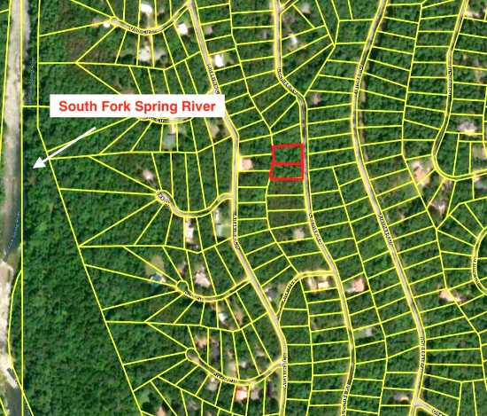
Build Your Home in Cherokee Village, Arkansas!
NOTE: Click on the Approximate Coordinates link below to explore the area on Google Maps. Zoom in for a detailed view of local attractions, roads, etc., or zoom out for a wider perspective of the surrounding region.
Parcel ID: 240-00025-000
Legal Description: Subdivision: BROKEN BOW Lot: 6 Block: 2
Acre: 0.17
State: Arkansas
County: Sharp
Taxes: Under $12 per month
Approximate Coordinates: 36°18'23.8"N 91°31'12.1"W
Imagine living in this beautiful four seasons serene location in the Arkansas Ozarks!
This lot sits off Broken Bow Drive, a short distance from Lake Cherokee, Papoosa Park and Cherokee Park. The Cherokee Village North & South Golf Courses are about 10 minutes away!
A home may be constructed on this lot so long as the house size is a minimum of 400 square feet and complies with the zoning set forth in Cherokee Village Zoning "Bill of Assurance": Broken Bow Addition
Airbnbs are an acceptable use. In fact, they have some in the community already and the process of registering for the licenses is simple and costs under $40.
Considering retirement, a new start for your family, just ready for a change, or looking for a part-time retreat? Cherokee Village offers small town charm, first-class outdoor recreation amenities and affordability. Take advantage of the low taxes, low cost of living and low housing costs. Your housing dollars stretch further here.
Experience Cherokee Village >>
Cherokee Village is the perfect backdrop for your next adventure. Come enjoy the lakes, river, golf courses, parks, trails, RV and campground. With more than 13,000 acres set among the rolling hills and pristine natural beauty of the Arkansas Ozarks, Cherokee Village has something to offer all ages.
Soak up the sun on the private beach, hit the links on two private 18-hole golf courses, jump right into any of the six swimming pools, go RVing and camping, take a swing at pickleball and tennis, spend the day fishing, walk any of the nature trails, workout at the fitness center, meet some new friends at the senior center, cycle, hike, or just relax in a hammock!
Boat, fish and play on any of the seven lakes. Enjoy the year-round spring-fed South Fork River that flows into neighboring Spring River. Both rivers rank among the Ozark region’s most popular destinations for floating and trout and walleye fishing.
Seize the opportunity to make this peaceful Arkansas retreat your own and start living the dream in Cherokee Village today!
NOTE: Real estate taxes are current. The buyer will be responsible for all real estate taxes billed on March 1, 2025 that will be due October 15, 2025.
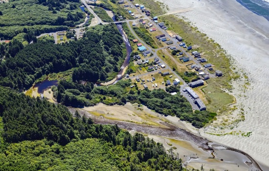
Explore Moclips Beach, Just Steps from the Pacific Ocean in Grays Harbor, Washington!
NOTE: Click on the Approximate Coordinates link below to explore the area on Google Maps. Zoom in for a detailed view of local attractions, roads, etc., or zoom out for a wider perspective of the surrounding region.
Parcel ID: 782501900100
Legal Description: Subdivision: Lot 2, Block 19, Townsite of Moclips, as per plat recorded in Volume 3 of Plats, page 38, Grays Harbor County
Acre: 0.075
State: Washington
County: Grays Harbor
Taxes: Under $5 per month
Approximate Coordinates: 47°14'41.9"N 124°13'06.7"W
Moclips is located in Grays Harbor County, an area that blends coastal attractions with forests, rivers, and small towns. The county is known for its maritime history, with Aberdeen and Hoquiam being the most significant urban centers in the region. This beautiful county is the Gateway to the Pacific Ocean and Washington's scenic coastal wonderland!
Explore Grays Harbor County >>
Moclips is a small coastal community along the Pacific Ocean. It’s a quiet and scenic town that offers beautiful ocean views, rugged coastline, and serene beaches, making it a popular getaway spot for those seeking a peaceful retreat.
This beach property is just steps away to the Pacific Ocean and the Moclips River! Being directly on the Pacific coast, its beach is one of the key attractions. The wide, sandy beach is ideal for beachcombing, walking, and enjoying coastal sunsets. This is your chance to own a piece of the beach!
The Best Things to Do Near Moclips Beach >>
The Moclips River runs near the town, providing additional scenic views and contributing to the area’s natural beauty.
Moclips is a hidden gem for those who love tranquil beach towns with a lot of historical and natural charm. It remains off the beaten path, offering a glimpse of Washington's beautiful and rugged coastline. Don't miss your chance to own a piece of this beautiful location!
NOTE: You are bidding only on Lot 2. Grays Harbor County has a tendency to change parcel numbers when properties are sold, so please understand that the property purchased will be the same, but the parcel number might change due to the county's accounting method.
Claim Your Camping Lot in St. Clair County, Missouri!
NOTE: Click on the Approximate Coordinates link below to explore the area on Google Maps. Zoom in for a detailed view of local attractions, roads, etc., or zoom out for a wider perspective of the surrounding region.
Parcel ID: 07-9.0-29-002-008-078.00
Legal Description: Lot 7, Blk 23, Plat 6, TOH
Acre: 0.13
State: Missouri
County: St. Clair
Taxes: Under $3 per month
Approximate Coordinates: 38°06'49.0"N 93°35'33.4"W
This 0.13 acre camping lot is located off of Falcon View Drive, in Twin Oaks Harbor, a gated community in Jackson Township, St. Clair County, Missouri. This community features camping lots with favorable rules for camping enthusiasts!
The community is located about 120 miles southwest of Kansas City. St. Clair County is a peaceful, rural, agricultural county with a population of under 10,000 but offers a myriad of outdoor opportunities. Appleton City and Osceola are the largest towns in the county.
Activities in St. Clair County, Missouri >>
The Harry S Truman Reservoir, also known as Truman Lake, offers exceptional outdoor recreational opportunities. It is great for boating, fishing, hunting, camping, hiking/biking and just exploring nature at its finest. Truman Lake encompasses 259 square miles of land and water covering portions of four counties: Benton, Henry, Hickory and St. Clair.
Plenty To Do at Truman Lake >>
Twin Oaks Harbor community amenities include a small lake that is stocked for fishing (boats are allowed as long as they are not gas-powered), an in-ground pool, a playground with new equipment, two bath houses with hot and cold running showers, trash dumpsters and road maintenance. ATVs, golf carts, etc. are permitted on the common roads.
This camping lot is for recreational use but is NOT permitted to be used as a residence (so no one can live there). Campers are allowed. No other structures are permitted on this lot.
Relax, rejuvenate, and reconnect under the stars in the great outdoors!
NOTE: Twin Oaks Harbor Property Owners Association imposes an annual fee of $232.00 for a single lot covering its fiscal year of May 1 – April 30. The 2024 annual POA dues are paid through April 2025. The buyer will be responsible for 2025-2026 fiscal year dues. A copy of the Covenants & Restrictions is available upon request!
Prime, Corner Lot in Lakewood Shores, Michigan: Build your Dream Home Here!
NOTE: Click on the Approximate Coordinates link below to explore the area on Google Maps. Zoom in for a detailed view of local attractions, roads, etc., or zoom out for a wider perspective of the surrounding region.
Parcel ID: 064-L21-000-225-00
Legal Description: LAKEWOOD SHORES GOLF & COUNTRY CLUB NO. 2 LOT 225
Acre: 0.51
State: Michigan
County: Iosco
Taxes: Under $3 per month
Approximate Coordinates: 44°29'48.9"N 83°21'00.2"W
Welcome to Lakewood Shores, an active community in Iosco County, Michigan, located in the northeast quarter of Michigan’s lower peninsula! Set peacefully along the shores of beautiful Lake Huron and the mighty Au Sable River, large portions of the county are forested and/or held in public ownership as national or state forest lands.
This wooded homesite features beautiful white birches, pines, and hardwoods, offering a serene setting for your primary home or seasonal retreat. Love outdoor recreation? Enjoy year-round activities such as water sports, camping, fishing, hunting, cross-country skiing, snowmobiling, and more!
This corner lot provides convenient access from Crestwood Drive along the eastern boundary and Devonshire Way along the northern side.
This community is 5.5 miles north of Oscoda Township, Michigan’s fastest growing community, with shopping malls, churches, medical services, education and recreation, just minutes away! Lovers of history and the outdoors alike know Oscoda as the home of the famous Lumberman's Monument located in the Lake Huron National Forest.
Lakewood Shores is bordered on the east by Lake Huron and on the west by the Alpena State Forest. In the center, you can find Cedar Lake creating a water enthusiast's paradise! From canoeing to sunbathing, the community provides activities for water enthusiasts of all varieties.
The fun doesn’t stop there! Lakewood Shores has so much more to offer, including a beach club, a clubhouse, white sandy beaches of cedar lake, marina causeway, docks, racquet club, tennis courts, locker rooms, snack bar, shuffle boards, 9 total beaches, 12 picnic areas, BBQ pits, fishing ponds, ball parks, basketball courts, badminton courts, and a playground.
Community Informational Brochure >>
Members may also take advantage of the Lakewood Shores Golf Resort Courses: the Serradella, Blackshire and The Gailes. These courses are among the finest in Northeast Michigan!
If golf is your sport, you do not want to let this opportunity pass you by!
NOTE: The Lakewood Shores Property Owner's Association (POA) manages this community. The buyer, upon purchase, is responsible for directly paying outstanding fees to the POA. The annual fee for 2025 is $270, with the buyer being responsible for the prorated share of the 2025 fee.
Quarter-Acre Lot Near the Mountains in New Mexico!
NOTE: Click on the Approximate Coordinates link below to explore the area on Google Maps. Zoom in for a detailed view of local attractions, roads, etc., or zoom out for a wider perspective of the surrounding region.
Parcel ID: 1022034035060310200
Legal Description: Subd: RIO DEL ORO Lot: 11 Block: 27 Unit: 25 .25 AC (+/-)
Acre: 0.25
State: New Mexico
County: Valencia
Taxes: Under $5 per Month
Approximate Coordinates: 34°44'29.6"N 106°31'10.6"W
Here's your chance to invest in land just minutes from the Manzano Expressway! It's an excellent time to invest in this prime location and the bright future of Valencia County, NM.
July 2024 Update: Approval was recently granted to rezone 268 acres of vacant land, primarily located between NM47 and 304, for manufacturing operations. This bodes well for the continued growth of Valencia County. Development usually breeds development, development brings jobs, and jobs bring people, usually families, who need housing!
Tens of thousands of new jobs are coming to Los Lunas. Facebook (Meta's) new facility opened in 2019 and continues to grow and generate additional economic benefits to the surrounding areas. The White House recently provided a grant to develop infrastructure for a huge new manufacturing facility. A new rail park is also under development.
Of course, more jobs in this sizzling investment area means greater demand for land.
Facebook (Meta) announces $800M expansion plan for Los Lunas Data Center >>
Once the expansion is completed, the Facebook (Meta) Data Center will employ 400 employees and provide significant economic benefits to the local community.
Facebook (Meta) Los Lunas Data Center and Facebook (Meta) Los Lunas Data Center Drone Video >>
New Facebook (Meta) Data Center + Booming Business in Los Lunas >>
In addition, the Cibola National Forest is just to the east and covers more than 1.6 million acres in New Mexico, with elevations ranging from 2,700 feet to over 11,300 feet. If you and your family enjoy picnicking, backpacking, camping, skiing, hiking, wildlife-viewing, star-gazing, horseback-riding, hunting, or mountain biking, Cibola National Forest has plenty to offer you.
See the beautiful mountains of Valencia County >>
Additionally, this property is located about 45 minutes from the Albuquerque International Sunport (ABQ).
NOTE: Approximately $200 in back taxes will be the responsibility of the buyer.
Build on a Golf Course Double Lot in Michigan's Northern Lower Peninsula!
NOTE: Click on the Approximate Coordinates link below to explore the area on Google Maps. Zoom in for a detailed view of local attractions, roads, etc., or zoom out for a wider perspective of the surrounding region.
Parcel ID: 043-100-000-017-00 & 043-100-000-018-00
Legal Description: 97 SPLIT FROM 042-011-100-005-00 & 042-011-200-050 -00 UNIT 17 AND UNIT 18 BLACKBEAR ESTATES SEC 11 T32N-R3W
Acre: 0.26
State: Michigan
County: Otsego
Taxes: Under $11 per month
Approximate Coordinates: 45°10'49.8"N 84°38'16.4"W
This building double lot is located between fairways of the Black Bear Golf Course in Vanderbilt, Michigan, a charming village located in Otsego County set within the natural beauty of Michigan's northern Lower Peninsula. It is a prime two-unit townhome site, near a scenic and recreational spot.
The Black Bear Estates Property Owners Association manages the community, offering a range of amenities and a close-knit neighborhood feel.
The challenging Black Bear Golf Course offers a distinctive Northern Michigan assortment of Scottish links style holes with traditional tree-lined holes. The course has undergone a renovation under new family-ownership since January 2024. Its amenities are everything you would come to expect of a perennial “People’s Choice Award Winner.” The clubhouse includes a popular grille and party room. Driving simulators are being added.
More About the Black Bear Golf Course >>
The surrounding area offers a combination of recreational amenities and diverse outdoor activities and attractions for nature enthusiasts and adventure seekers. The climate features cold winters and mild summers. This creates a perfect environment for snowmobiling and other winter sports, and the summer months are ideal for golfing, hiking, boating, and other outdoor activities.
The town of Gaylord is about 8 miles south of Vanderbilt, about a 12 minute drive. Gaylord is often called the "Alpine Village" because of its Bavarian-themed downtown. This gives the area a unique European charm, with quaint architecture, specialty shops, and local businesses that reflect this theme. The town has a small-town, friendly feel with a focus on community events, including festivals and fairs.
Learn More About Gaylord, Michigan >>
The area has several lakes and rivers where you can enjoy fishing and boating. Popular spots include Thumb Lake and the Sturgeon River.
Nearby, Otsego Lake State Park provides additional recreational facilities, featuring a campground with 155 sites, picnic areas, a boat launch, and a half-mile sandy swimming beach along the lake's southeast shore.
The Iron Belle Trail runs past the park entrance and offers biking, hiking and snowmobiling.
Don’t miss this opportunity!
NOTE: The Black Bear Estates Property Owners Association imposes annual dues of $2,400 for this double lot. These dues would be the responsibility of the buyer.
Breathtaking Arizona: 5 Acre Retreat in Navajo County!
NOTE: Click on the Approximate Coordinates link below to explore the area on Google Maps. Zoom in for a detailed view of local attractions, roads, etc., or zoom out for a wider perspective of the surrounding region.
Parcel ID: 104-95-031H
Legal Description: Section 21,T19N,R20E: S2 Sw4 Of Tract 48, Pueblo Mesa Ranches Out Of 104-95-031D For2006Roll
Acres: 4.98
State: Arizona
County: Navajo
Taxes: Under $5 per month
Approximate Coordinates: 35°01'32.5"N 110°13'29.0"W
This nearly five-acre parcel is located in Navajo County's Joseph City, a small, historic town located in northern Arizona along the iconic Route 66. Founded in 1876 by Mormon pioneers, it is the oldest Mormon settlement in Arizona that is still in existence. Surrounding this property, there are many attractions such as Lee Mountain, Marcou Mesa, Painted Hills and Minute Co-Sunsky Ranch.
Joseph City has a place in American history as part of the legendary highway. Although it's a small stop, it retains a sense of nostalgia for road trippers exploring the historic route. Also, it’s conveniently located near Interstate 40, making it easy to reach larger cities like Flagstaff (about 90 miles west) and Holbrook (just 12 miles east).
It’s hard to say what takes center stage in Holbrook. It’s a canvas painted with mid-century Route 66 kitsch, Wild West characters, and unforgettable landscapes. Cherished for its roadside Americana charm, Holbrook sits within the Painted Desert, a remarkable area of rocky badlands that stretches from the Grand Canyon to the Navajo Nation. It’s one of Arizona’s most dazzling and lonesome landscapes, with layered bands that change color seemingly every hour.
You can easily get lost in the history, beauty, and culture of this wondrous city. From star gazing, hiking trails, campgrounds, national monuments, historical parks, museums, trading posts, and the Twin Arrows Casino Resort, there is definitely something for everyone!
This parcel is also about an hour drive to the Petrified Forest National Park! In its south, the Rainbow Forest is full of colorful petrified wood. It's home to the Rainbow Forest Museum, with its paleontology exhibits and many trail access points. In the park's center are the petroglyphs of Newspaper Rock and the ruined village of Puerco Pueblo. To the north, the Painted Desert Inn, a 1930s adobe building, is a museum with Hopi murals.
Things To Do: Petrified Forest National Park >>
Own a piece of land that once served one of the greatest Native American tribes, the Navajo Nation. Immerse yourself in the beauty of this one of a kind, diverse culture!
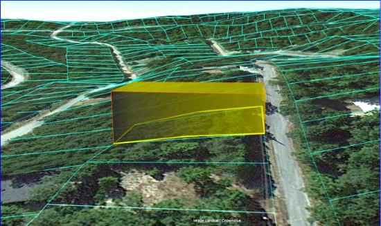
Vacant Lot near Manistee Lake in Kalkaska County, Michigan!
NOTE: Click on the Approximate Coordinates link below to explore the area on Google Maps. Zoom in for a detailed view of local attractions, roads, etc., or zoom out for a wider perspective of the surrounding region.
Parcel ID: 005-141-003-00
Legal Description: LOT 5 BLOCK B SECOND ADD TO CHIPPEWA BEACH SEC 35 T28N-R6W
Acre: 0.37
State: Michigan
County: Kalkaska
Taxes: Under $14 per month
Approximate Coordinates: 44°46'32.0"N 85°00'22.7"W
Kalkaska County is a scenic and rural area located in the northern part of Michigan’s Lower Peninsula. Known for its outdoor recreational opportunities, natural beauty, and rich local culture, the county offers a peaceful escape for residents and visitors alike.
Learn More About the County! >>
The county is home to over 80 inland lakes, including Torch Lake, Starvation Lake, and Bear Lake. These lakes provide ample opportunities for boating, fishing, swimming, and other water-related activities. Sleeping Bear Dunes National Lakeshore is about an hour away. One of the county's major natural features, the Manistee River, is a popular destination. The river is known for its clean, clear water and is especially famous for trout fishing.
Kalkaska County has miles of trails that are perfect for hiking, mountain biking, and horseback riding. Many of these trails wind through state forests, offering scenic views and wildlife sightings.
This lot is located in Coldsprings Township, just a short distance to Manistee Lake! The 800+ acre lake is a popular recreational location known for fishing, boating, water sports and more!
Kalkaska County is only about a 25-minute drive from Traverse City, one of Michigan’s top tourist destinations. Traverse City offers shopping, dining, and entertainment, along with its well-known wineries and proximity to Lake Michigan.
Overall Kalkaska County, Michigan, is a hidden gem in northern Michigan, offering natural beauty, a welcoming small-town atmosphere, and a wide variety of outdoor activities. With its forests, lakes, and rivers, the county is perfect for those who love fishing, hiking, snowmobiling, and simply enjoying nature. The affordable cost of living, rich history, and close proximity to Traverse City and other northern Michigan destinations make it an attractive place to live, visit, or invest in property. Whether you’re seeking adventure in the great outdoors or looking for a peaceful rural lifestyle, Kalkaska County offers something for everyone.

Invest in Growth in Valencia County, New Mexico!
NOTE: Click on the Approximate Coordinates link below to explore the area on Google Maps. Zoom in for a detailed view of local attractions, roads, etc., or zoom out for a wider perspective of the surrounding region.
Parcel ID: 1019034140465116260
Legal Description: Subd: RIO DEL ORO Lot: 26 Block: 47 Unit: 15 .25 AC
Acre: 0.25
State: New Mexico
County: Valencia
Taxes: Under $5 per month
Approximate Coordinates: 34°45'12.0"N 106°34'07.3"W
This warm-weather location has the country buzzing about it!
July 2024 Update: Approval was recently granted to rezone 268 acres of vacant land, primarily located between NM47 and 304, for manufacturing operations. This bodes well for the continued growth of Valencia County. Development usually breeds development, development brings jobs, and jobs bring people, usually families, who need housing!
Valencia County Welcomes You! >>
Drive the Rio Del Oro Loop! >>
In addition to being rich in culture and a great place to raise a family, Valencia County is experiencing a great deal of economic prosperity. There are so many new and exciting things happening to this already charming location, you cannot miss the chance to buy your land in Valencia County today!
Tens of thousands of new jobs are coming to Los Lunas. Facebook (Meta's) new facility opened in 2019 and continues to grow and generate additional economic benefits to the surrounding areas. The White House recently provided a grant to develop infrastructure for a huge new manufacturing facility. A new rail park is also under development.
Of course, more jobs in this sizzling investment area means greater demand for land.
Facebook (Meta) announces $800M expansion plan for Los Lunas Data Center >>
Once the expansion is completed, the Facebook (Meta) Data Center will employ 400 employees and provide significant economic benefits to the local community.
Facebook (Meta) Los Lunas Data Center and Facebook (Meta) Los Lunas Data Center Drone Video >>
New Facebook (Meta) Data Center + Booming Business in Los Lunas >>
In addition, the Cibola National Forest is just to the east and covers more than 1.6 million acres in New Mexico, with elevations ranging from 2,700 feet to over 11,300 feet. If you and your family enjoy picnicking, backpacking, camping, skiing, hiking, wildlife-viewing, star-gazing, horseback-riding, hunting, or mountain biking, Cibola National Forest has plenty to offer you.
See the beautiful mountains of Valencia County >>
NOTE: Approximately $250 in back taxes will be the responsibility of the buyer.
Michigan's Upper Peninsula: Lot Near the Menominee River!
NOTE: Click on the Approximate Coordinates link below to explore the area on Google Maps. Zoom in for a detailed view of local attractions, roads, etc., or zoom out for a wider perspective of the surrounding region.
Parcel ID: 002-481-012-00
Legal Description: LOT 12 BLK 1. FIRST ADD TO EAST BREITUNG.
Acre: 0.29
State: Michigan
County: Dickinson
Taxes: Under $8 per month
Approximate Coordinates: 45°47'22.4"N 88°03'26.7"W
If you are looking for an adventure, you can certainly find it in Michigan’s Upper Peninsula! Besides thrilling wilderness adventures, you can also enjoy natural serenity, historical attractions, and four-season beauty.
Michigan's Upper Peninsula! >>
This prime wooded lot is conveniently located in Kingsford within Dickinson County, in Michigan’s western Upper Peninsula bordering the Menominee River that serves as the state line between Michigan and Wisconsin.
Shoot down the region’s most intense rapids or see some of the country’s best athletes prepare for the Olympics!
Explore the UP Shore - Dickinson County >>
This lot is within a 15-minute drive of Fumee Lake, Pine Mountain Ski & Golf Resort, and the Golf Digest top-rated golfing destination, Timberstone, where golf and nature come together!
Enjoy horseback riding, cross country skiing, biking, hiking, bird watching, canoeing, kayaking, whitewater rafting, rock climbing, golf, fishing, snowmobiles, fascinating history attractions, craft beers and more!
Lots to Do in Dickinson County >>
Thrill seekers can shoot down the region’s most intense whitewater rafting through Piers Gorge on the Menominee River, the only Class IV rapids in the Midwest.
Whitewater Rafting in the Menominee River >>
Experience Whitewater Rafting >>
For a more relaxing time, canoe, kayak or fish on rivers or inland lakes across the county.
Take a historic journey and go back in time to visit the WWII Glider & Military Museum and learn the Ford plant in Kingsford being converted to make wooden gliders to fly reconnaissance missions over the English Channel.
In winter, visit the giant Pine Mountain Ski Jump in nearby Iron Mountain, the largest ski jumping facility in North America. You can ski the Pine Mountain ski area or its lit cross-country trails. For motorized fun, snowmobile on 120 miles of trails.
Dickinson County offers non-stop activities to please everyone! Bid today!
Build in Charming Cherokee Village, Arkansas!
NOTE: Click on the Approximate Coordinates link below to explore the area on Google Maps. Zoom in for a detailed view of local attractions, roads, etc., or zoom out for a wider perspective of the surrounding region.
Parcel ID: 370-20359-000
Legal Description: Subdivision: Teton Lot: 7 Block: 7
Acre: 0.29
State: Arkansas
County: Fulton
Taxes: Under $12 per Month
Approximate Coordinates: 36°17'11.9"N 91°36'37.5"W
Imagine living in this beautiful four seasons serene location in the Arkansas Ozarks!
A home may be constructed on this lot as long as the house size is a minimum of 1,000 square feet and complies with the zoning set forth in Cherokee Village Zoning "Bill of Assurance": Teton Addition
In addition, Airbnbs are also an acceptable use! In fact, this community has some already and the process of registering for the license is simple and costs under $40.
Considering retirement, a new start for your family, just ready for a change, or looking for a part-time retreat? Cherokee Village offers small town charm, first-class outdoor recreation amenities and affordability. Take advantage of the low taxes, low cost of living and low housing costs. Your housing dollars stretch further here.
Experience Cherokee Village >>
Cherokee Village is the perfect backdrop for your next adventure. Come enjoy the lakes, river, golf courses, parks, trails, RV and campground. With more than 13,000 acres set among the rolling hills and pristine natural beauty of the Arkansas Ozarks, Cherokee Village has something to offer all ages.
Soak up the sun on the private beach, hit the links on two private 18-hole golf courses, jump right into any of the six swimming pools, go RVing and camping, take a swing at pickleball and tennis, spend the day fishing, walk any of the nature trails, workout at the fitness center, meet some new friends at the senior center, cycle, hike, or just relax in a hammock!
Boat, fish and play on any of the seven lakes. Enjoy the year-round spring-fed South Fork River that flows into neighboring Spring River. Both rivers rank among the Ozark region’s most popular destinations for floating and trout and walleye fishing.
Don’t miss your chance to own a piece of this hidden gem in the heart of the Arkansas Ozarks!
NOTE: Real estate taxes are current. The buyer will be responsible for all real estate taxes billed on March 1, 2025 that will be due October 15, 2025.
1.27 Acre Wooded Lot in Polk County, Florida!
NOTE: Click on the Approximate Coordinates link below to explore the area on Google Maps. Zoom in for a detailed view of local attractions, roads, etc., or zoom out for a wider perspective of the surrounding region.
Parcel ID: 313135000000032110
Legal Description: W1/2 OF SE1/4 OF SW1/4 OF SE1/4 OF NW1/4 LESS 1/2; INT IN OIL GAS AND MINERAL RIGHTS
Acres: 1.27
State: Florida
County: Polk
Taxes: Under $2 per month
Approximate Coordinates: 27°44'21.5"N 81°11'49.4"W
Here is your chance to own a piece of Florida!
This 1.27 acre plat of land is located in a peaceful, wooded area in southeastern Polk County, surrounded by Lakes Kissimmee, Weohyakapka, and Arbuckle, among others. It is located about 85 miles south of Orlando and 90 miles east of Tampa.
This parcel does not have frontage on a county maintained road. For this reason, the starting bid is deeply discounted, enhancing the attractiveness of this parcel as a long term investment.
With over 2,000 square miles of land and water, Polk County is Florida’s fourth largest county. Polk County is located in the geographic center of Florida and along Central Florida’s I-4 corridor.
Florida has surpassed New York as the third-largest state in terms of population, going from 18,801,310 residents in 2010 to 22,359,251 (and counting) in 2023. This growth pushes up demand for land needed for additional housing, facilities to serve the growing population, and so on!
See why Polk County is one of the fastest growing counties! >>
With millions of visitors each year to its beaches, major amusement parks centered around Orlando and cruise ships departing from ports on both coasts, tourism is a major contributor to Florida's robust economy.
Purchasing this piece of Florida will diversify your investment portfolio, don’t miss this opportunity!
NOTE: Polk County does not permit living in RVs at any time.
NOTE: This property is located in the vicinity of the Avon Park Air Force Range Military Training Facility and may be subject to potential day and night low level aircraft overflight and military training noise during training exercises.
Cheboygan County, Michigan: Prime Lot by the Golf Course!
NOTE: Click on the Approximate Coordinates link below to explore the area on Google Maps. Zoom in for a detailed view of local attractions, roads, etc., or zoom out for a wider perspective of the surrounding region.
Parcel ID: 251-G01-000-028-00
Legal Description: GOLFVIEW ESTATES SUB, LOT 28. (SEC 21,T33N,R2W) 297/504
Acre: 0.34
State: Michigan
County: Cheboygan
Taxes: Under $8 per month
Approximate Coordinates: 45°14'25.7"N 84°34'03.1"W
Cheboygan County is situated in the northern part of Michigan's Lower Peninsula partly along Lake Huron's shoreline. It is known for its scenic beauty, with a mix of forests, lakes, and rivers allowing ample opportunities for boating, fishing, hiking and hunting.
Area Activities & Attractions! >>
Your Cheboygan County Bucket List! >>
This 0.34 Acre Lot is located on Golfcrest Drive, in the Wildwood Lakes Community in Cheboygan County, Michigan.
The surrounding area features the 227-acre Lake, residential properties, recreational areas, and amenities such as the Wildwood Lakes Golf Course. This 9-hole, par 35 golf course offers a scenic setting for both residents and visitors.
The community is known for its natural beauty, with the lake providing opportunities for fishing, boating, and other water-related activities. The area also offers hiking trails and parks, making it a desirable location for outdoor enthusiasts.
Overall, this peaceful community is enjoyed by residents and visitors alike. There is something here for everyone! Place your bid to become the new owner of this property in this beautiful location!
NOTE: This lot is located in an area where the active Wildwood Valley Property Owners Association exists. Membership is non-mandatory and the buyer can decide to join at any time if they desire. Current Annual dues are $75 and may increase in 2025.
Build Your Dream Home or Airbnb on Adjacent Lots in Arkansas!
NOTE: Click on the Approximate Coordinates link below to explore the area on Google Maps. Zoom in for a detailed view of local attractions, roads, etc., or zoom out for a wider perspective of the surrounding region.
Parcel ID/Legal Description: 268-00405-000 Subdivision: KIMA SECOND Lot: 8 Block: 12, 268-00404-000 Subdivision: KIMA SECOND Lot: 7 Block: 12
Acre: 0.58 in Total
State: Arkansas
County: Sharp
Taxes: Under $25 per month
Approximate Coordinates: 36°19'02.5"N 91°31'25.3"W
Imagine living in this beautiful four-seasons serene location in the Arkansas Ozarks!
Experience Cherokee Village >>
These two contiguous lots sit on Cochise Road. A home may be constructed on these lots so long as the house size is a minimum of 800 square feet and complies with the zoning set forth in Cherokee Village Zoning "Bill of Assurance": Kima Second Addition.
In addition, Airbnbs are also an acceptable use! In fact, this community has some already and the process of registering for the license is simple and costs under $40.
Considering retirement, a new start for your family, just ready for a change, or looking for a part-time retreat? Cherokee Village offers small town charm, first-class outdoor recreation amenities and affordability. Take advantage of the low taxes, low cost of living and low housing costs. Your housing dollars stretch further here.
Cherokee Village Information >>
Cherokee Village is the perfect backdrop for your next adventure. Come enjoy the lakes, river, golf courses, parks, trails, RV and campground. With more than 13,000 acres set among the rolling hills and pristine natural beauty of the Arkansas Ozarks, Cherokee Village has something to offer all ages.
Cherokee Village, Arkansas - Retreat, Rest and Renewal >>
Soak up the sun on our seven lakes, hit the links on our two private 18-hole golf courses, jump right into any of our six swimming pools, go RVing and camping, take a swing at pickleball and tennis, spend the day fishing, walk any of our nature trails, workout at our fitness center, meet some new friends at our senior center, cycling and hiking or just relax in a hammock.
Boat, fish and play on our seven lakes. Enjoy the year-round spring-fed South Fork River that flows into neighboring Spring River. Both rivers rank among the Ozark region's most popular destinations for floating and trout and walleye fishing.
Lots of opportunities await here in Cherokee Village! Place your bid today!
NOTE: Real estate taxes are current. The buyer will be responsible for all real estate taxes billed on March 1, 2025 that will be due October 15, 2025.
