Affordable Land Nationwide: Bid Today!
Affordable Land Nationwide: Bid Today!

See Special Terms for additional fees
Description


Over Half-An-Acre Homesite in Iosco County, Michigan!
NOTE: Click on the Approximate Coordinates link below to explore the area on Google Maps. Zoom in for a detailed view of local attractions, roads, etc., or zoom out for a wider perspective of the surrounding region.
Parcel ID: 064-L51-000-088-00
Legal Description: LAKEWOOD SOUTH NO. 2 SUB LOT 88
Acre: 0.54
State: Michigan
County: Iosco
Taxes: Under $5 per month
Approximate Coordinates: 44°28'56.8"N 83°19'19.6"W
Welcome to Lakewood Shores, an active community in Iosco County, Michigan, located in the northeast quarter of Michigan’s lower peninsula! Set peacefully along the shores of beautiful Lake Huron and the mighty Au Sable River, large portions of the county are forested and/or held in public ownership as national or state forest lands.
Lakewood Shores is bordered on the east by Lake Huron and on the west by the Alpena State Forest. In the center, you can find Cedar Lake creating a water enthusiasts paradise! From canoeing to sunbathing, the community provides activities for water enthusiasts of all varieties.
The fun doesn’t stop there! Lakewood Shores has so much more to offer, including a beach club, a clubhouse, white sandy beaches of cedar lake, marina causeway, docks, racquet club, tennis courts, locker rooms, snack bar, shuffle boards, 9 total beaches, 12 picnic areas, BBQ pits, fishing ponds, ball parks, basketball courts, badminton courts, and a playground.
Community Informational Brochure >>
Members may also take advantage of the Lakewood Shores Golf Resort Courses: the Serradella, Blackshire and The Gailes. These courses are among the finest in Northeast Michigan!
This 0.54-acre lot, located on Woodlea Road West, is wooded with beautiful white birches, pines and hardwoods. Looking for a new primary home or a place to get away seasonally throughout the year? Do you enjoy year-round recreational activities such as water sports, camping, fishing, hunting, cross country skiing, snowmobiling and more? Look no further!
This community is 5.5 miles north of Oscoda Township, Michigan’s fastest growing community, with shopping malls, churches, medical services, education and recreation, just minutes away! Lovers of history and the outdoors alike know Oscoda as the home of the famous Lumberman's Monument located in the Lake Huron National Forest.
Take advantage of everything Lakewood Shores has to offer!
NOTE: The Lakewood Shores Property Owner's Association (POA) manages this community. The buyer, upon purchase, is responsible for directly paying outstanding fees to the POA. The annual fee for 2025 will be $270, due upon transfer of the property.

Residential Lot Available in Lincoln County, Georgia!
NOTE: Click on the Poperty Address link below to explore the area on Google Maps. Zoom in for a detailed view of local attractions, roads, etc., or zoom out for a wider perspective of the surrounding region.
Parcel ID: 0010A-00000-301-000
Legal Description: Lot 301 Phase II Stillwater Coves
Acres: 1.86
State: Georgia
County: Lincoln
Taxes: Under $5 per month
Property Address: 1197 Hardwood Dr, Tignall, GA 30668
Build your new home on this 1.86 acre lake view property in Stillwater Coves, Lincoln County, Georgia!
Lincoln County is a small, rural county located in the eastern Piedmont region of Georgia, very close to the South Carolina border. It is situated along the western shore of the Clarks Hill Lake, also known as Lake Thurmond. Lincoln County is known for its tight-knit community, southern hospitality, and small-town charm.
This beautiful property is located in Stillwater Coves, a residential community located in Tignall, on the shores of Lake Thurmond. Tignall embodies the small-town atmosphere, with a strong sense of community, traditional values, and a slower pace of life. The proximity to historical sites and the natural beauty of the region offer potential for tourism, particularly for those interested in Georgia’s history or seeking a peaceful rural getaway.
Residents enjoy easy access to boating, fishing, kayaking, and other water sports. The area offers scenic views, outdoor recreational activities, and a tranquil lifestyle, making it appealing for those seeking a lakeside or countryside retreat.
Experience the Georgia River Trails >>
Planned amenities for the community include a landscaped entry way, easy access day docks, boat storage, pool with bath house, walking trails, and a community pavilion complete with a summer kitchen, open fireplace, and a picnic area.
Stillwater Coves' community theme is a neighborhood of Southern summer homes that have a look and feel of the houses reminiscent of early 20th century retreats in the South.
All site work, structures and landscaping are subject to design and aesthetics approval that meet the community’s Design Review Guidelines, Style Book and Covenants (available upon request).
Homes must have a minimum of 1,300 SF of heated space on the main level and a maximum of 5,800 SF in total. All utilities (water, sewer and electricity) are at the curb for home construction.
Besides lake activities, the area around Stillwater Coves offers parks, hiking trails, wildlife management areas and campgrounds, including the popular, nearby campground, Hester's Ferry.
Georgia Freshwater Camping - Hesters Ferry >>
The Richard B. Russell State Park and Clarks Hill Wildlife Management Area are also popular destinations for outdoor enthusiasts.
Explore Richard B. Russell State Park >>
Overall, Stillwater Coves provides a peaceful, nature-oriented lifestyle, perfect for those who enjoy lakeside living in a quiet, rural setting.
Claim this prime property today!
NOTE: This property is located within the Stillwater Coves HOA, managed by Silverleaf Management Company. The annual dues of $700.00 were paid in full in December 2024. Buyer will be responsible for 2025 dues and a $109 initiation fee.

Close to the Shoreline of Lake Erie!
NOTE: Click on the Approximate Coordinates link below to explore the area on Google Maps. Zoom in for a detailed view of local attractions, roads, etc., or zoom out for a wider perspective of the surrounding region.
Parcel ID: 09 180 073 00
Legal Description: NORTH SHORES PLAT NO. 1 LOT 88
Acre: 0.11
State: Michigan
County: Monroe
Taxes: Under $12 per month
Approximate Coordinates: 41°50'01.1"N 83°24'43.5"W
Monroe County in the fall offers a beautiful seasonal transformation, with vibrant colors and numerous activities to enjoy. Monroe County is a historical and beautiful community set in the southeastern corner of Michigan, bordering Ohio to the south and Lake Erie to the east.
The city of Monroe has impressive parks and recreational land – around 300 acres, in addition to the non-motorized River Raisin Heritage Trail. Parks contain a wide variety of recreational amenities, including picnic facilities, hiking, athletic fields, concert venues, war memorials, fishing, kayaking, boat launch, open space, and historical sites.
A Tour of the City of Monroe >>
There are activities for everyone in Monroe County!
The River Raisin Battlefield Park, which takes on a different charm in the fall, makes Monroe County a great place to live. Monroe’s location on the shore of Lake Erie provides opportunities for swimming, boating, and fishing.
Sterling State Park is the only Michigan park on Lake Erie. The park’s 1,300 acres include more than a mile of sandy beach, boating and shore fishing, a fishing lagoon, lakefront camping, wildlife viewing and seven miles of trails.
Pointe Mouillee State Game Area is one of the most respected waterfowl locations in Michigan. Consisting of over 4,000 acres, it offers exceptional waterfowl hunting. And, its numerous bird species and habitat diversity make it an important birding site for Bald Eagles, Black Billed Plovers, Glossy Ibises, Osprey, and Whimbrels.
Things to Do in Pointe Mouillee >>
Don’t miss this opportunity to enjoy Monroe County, the cornerstone of Michigan!

Discover Baxter County, Arkansas: Gateway to the Ozarks!
NOTE: Click on the Approximate Coordinates link below to explore the area on Google Maps. Zoom in for a detailed view of local attractions, roads, etc., or zoom out for a wider perspective of the surrounding region.
Parcel ID: 010-02181-000
Legal Description: LOT 52 SEC 14 BRIARCLIFF
Acre: 0.27
State: Arkansas
County: Baxter
Taxes: Under $10 per month
Approximate Coordinates: 36°15'32.8"N 92°16'33.6"W
Baxter County, located in the Ozark Mountains of Arkansas, is known for its beautiful lakes, the White River, and the Ozark National Forest. Established in 1873, the county offers abundant outdoor activities like hiking and fishing. Mountain Home, the county seat, serves as the region's hub for commerce, healthcare, and education, including Arkansas State University-Mountain Home.
One of the area’s crown jewels is Norfork Lake, a premier destination for outdoor enthusiasts. Spanning over 3,000 acres, this crystal-clear lake offers exceptional boating, fishing, swimming, and camping, all set against the breathtaking backdrop of the Ozark Mountains.
This property is just 1.8 miles from Norfork Lake, giving you access to all the recreational activities the area has to offer. Whether you’re seeking a peaceful retreat or an action-packed outdoor escape, this lot places you at the heart of it all.
Rich in history, Baxter County features landmarks such as the Jacob Wolf House, Arkansas’s oldest existing courthouse. The local economy is driven by tourism, agriculture, and retail, with annual events like the Cotter Trout Festival celebrating its outdoor lifestyle. Baxter County combines natural beauty, history, and community spirit, making it a popular destination.
Don’t miss the chance to make this beautiful corner of the Ozarks your own — where nature, history, and adventure come together.

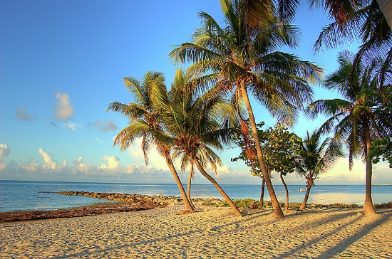
Pair of Adjacent Lots in Harbour Heights, Florida!
NOTE: Click on the Approximate Coordinates link below to explore the area on Google Maps. Zoom in for a detailed view of local attractions, roads, etc., or zoom out for a wider perspective of the surrounding region.
Parcel ID: 402302351006
Legal Description: HARB HTS SEC 13 BLK 197 LTS 11 & 12 295/834 DC1111/614-RLJ DC1350/1215-EH 1350/1216 TD3493836
Acre: 0.23
State: Florida
County: Charlotte
Taxes: Under $8 per month
Approximate Coordinates: 27°01'12.7"N 81°59'26.2"W
Located in Charlotte County, Florida, Harbour Heights is an unincorporated waterfront community situated along the scenic Peace River. It offers a laid-back, residential atmosphere with a focus on outdoor activities, especially boating and fishing, making it attractive to retirees, seasonal residents, and families seeking a peaceful lifestyle.
Port Charlotte, FL Video Tour: Affordable Resort - Town Living! >>
This pair of adjacent lots are located just a stone's throw to Peace River, close to Paramaribo St, and just a short drive to many attractions, such as Deep Creek Golf Club, Port Charlotte, and Port Charlotte Beach Park.
Experience a Florida Camping and Canoe Adventure on the Peace River! >>
While Harbour Heights is primarily residential, nearby Punta Gorda and Port Charlotte provide access to more extensive shopping, dining, and healthcare services. The area is quiet, and the community tends to be close-knit, with an emphasis on outdoor living.
The peaceful atmosphere makes it a perfect place for anyone looking for a tranquil and relaxing retreat. Come and explore all that Charlotte County has to offer!
NOTE: County does not permit living in RVs at any time unless a house has been constructed on the lot.
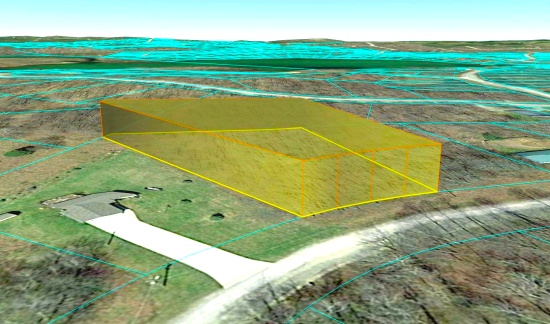
Build Your Dream Home in Lakes of the North, Michigan!
NOTE: Click on the Approximate Coordinates link below to explore the area on Google Maps. Zoom in for a detailed view of local attractions, roads, etc., or zoom out for a wider perspective of the surrounding region.
Parcel ID: 05-11-575-395-00
Legal Description: LOT 395 WHISPERING PINES
Acre: 0.79
State: Michigan
County: Antrim
Taxes: Under $4 per month
Approximate Coordinates: 44°56'25.7"N 84°53'39.7"W
Enjoy the four seasons from your new home in the Lakes of the North community in Antrim County. This peaceful and quiet location transforms seasonally from snow-covered white in winter, to spring green, to comfortable summer days, then magnificent shades in fall. The community is located about 20 minutes from Boyne Mountain Resort and Shanty Creek Resort; and 45 minutes from Traverse City or 25 minutes from Gaylord.
Things to See & Do in Antrim County! >>
Lakes of the North is a group of 19 subdivisions that straddles the Otsego-Antrim county line.
Amenities include an 18-Hole Golf Course, Pro-Shop, full-service Restaurant/Tavern all of which are Open to the Public. Member exclusive areas include Pencil Lake and Harold Lake beach access and beach houses, Activities Clubhouse with a Pool, Whirlpool, Water Slide, along with two outdoor Tennis/Pickleball Courts, Shuffleboard, Horseshoes and playground.
The Winter Sports area has an Ice Rink, Cross Country Ski and Snowshoe trails which serve as hiking trails in the summer.
Campers Village is an all-season facility for members to enjoy with their camper.
Throughout and surrounding Lakes of the North you will find hundreds of miles of ATV/Snowmobile Trails to ride on.
Learn About Lakes of the North Association >>
This lot is located in the Whispering Pines subdivision on Sky Trail Circle near Lake Harold.
Each vacant lot in Lakes of the North is buildable and is rural in character. All building plans need approval by the association's Architectural Control Committee. Lots do not have water, septic, or electricity. Construction would require a private well and sewage disposal system. If there is electricity in the area, it can be extended to your lot.
Building restrictions include a minimum square footage that varies by subdivision. Mobile homes, trailers, camping and storage are prohibited on all vacant lots. Commercial use is also prohibited (including for rentals and short-term rentals).
For complete building information, please see Lakes of the North – Restrictive Covenants, paying particular attention to Article VI (Architectural Control Committee) and Article VII (Building and Use Limitations).
Lakes of the North is known for its picturesque landscapes, featuring serene lakes surrounded by lush forests and offering a peaceful retreat for residents and visitors alike. Bid now!
NOTE: The Association’s 2025 annual assessment is $380 for the primary lot and $214 for subsequent lots. This fee covers the period from April 1, 2025 to March 31, 2026. The buyer will be responsible for payment of the amount of the annual assessment in the fiscal year when the deed is recorded. The buyer must also register with the Association as a land owner by completing the required document (to be provided along with the recorded deed).

FINANCE 20 Buildable Lots in Cherokee Village, Arkansas! YOUR BID IS YOUR DOWN PAYMENT.
See Photo for Parcel Numbers, Lot Sizes and Legal Descriptions
This package of 20 lots is available in Sharp County, Arkansas, a beautiful four-seasons serene location in the Arkansas Ozarks! The lots are scattered throughout the Cherokee Village and are not contiguous.
Experience Cherokee Village >>
Cherokee Village Information >>
As the owner of these lots, the possibilities are endless. Hold them as-is as long-term investments. Build to rent or to resell. This is a great community for a part-time retreat or a full-time residence, or for those considering retirement, a new start for their family, or just ready for a change! Cherokee Village offers small town charm, first-class outdoor recreation amenities and affordability. Take advantage of the low taxes, low cost of living and low housing costs. Your housing dollars stretch further here.
A home may be constructed on these lots so long as the house sizes are a minimum of 800 sq feet and complies with the zoning set forth in Cherokee Village Zoning "Bill of Assurances" below.
An Airbnb is also an acceptable use! In fact, they have some in the community already and the process of registering for the license is simple and costs under $40!
Cherokee Village is the perfect backdrop for your next adventure. Come enjoy the lakes, river, golf courses, parks, trails, RV and campground. With more than 13,000 acres set among the rolling hills and pristine natural beauty of the Arkansas Ozarks, Cherokee Village has something to offer all ages.
Cherokee Village, Arkansas - Retreat, Rest and Renew >>
Boat, fish and play on any of the seven lakes, hit the links on the two private 18-hole golf courses, jump right into any of the six swimming pools, go RVing and camping, take a swing at pickleball and tennis, spend the day fishing, walk any of the nature trails, workout at the fitness center, meet some new friends at the senior center, cycle, hike, or just relax in a hammock!
Enjoy the year-round spring-fed South Fork River that flows into neighboring Spring River. Both rivers rank among the Ozark region’s most popular destinations for floating and trout and walleye fishing.
More About Cherokee Village >>
Don't miss your opportunity to own land in the Cherokee Village Community!
YOUR BID IS YOUR DOWN PAYMENT. The total purchase price will be $35,995. The difference between $35,995 and the winning bid will be financed over 48 months at 9.9%. The winning bidder will be required to formally enter into a contract with complete terms and conditions as set forth in this specimen contract:
The Winning Bidder will be sent a Contract for Deed, complete with all applicable terms, and ready for signature.
NOTE: Real estate taxes are current. The buyer will be responsible for all real estate taxes billed on March 1, 2025 that will be due October 15, 2025.

Buildable Corner Lot in California Pines!
NOTE: Click on the Approximate Coordinates link below to explore the area on Google Maps. Zoom in for a detailed view of local attractions, roads, etc., or zoom out for a wider perspective of the surrounding region.
Parcel ID: 036-014-003-000
Legal Description: Lot 24, Block 7, California Pines Unit Lake 1-A, a subdivision of the County of Modoc according to the official Plat thereof, filed in Book 2 of Maps in Modoc County Records.
Acres: 1.08
State: California
County: Modoc
Taxes: Under $25 per month
Approximate Coordinates: 41°24'59.8"N 120°43'01.4"W
Nestled in the northeastern corner of California, Modoc County is a tranquil and picturesque haven filled with untouched natural beauty and a laid-back, small-town charm. Blessed with breathtaking landscapes, this county boasts rolling meadows, pristine lakes, and towering mountains, offering outdoor enthusiasts a playground for hiking, hunting, fishing, and wildlife observation.
Modoc County's unspoiled beauty invites you to explore and discover hidden gems. Whether you're interested in photography, geology, or history, there's always something new to uncover in the region.
Welcome to Modoc County, California >>
This corner 1.08 acre lot is located in Unit 1-A of the Lake District of California Pines, a beautiful community located about 12 miles southwest of the City of Alturas in Modoc County. California Pines covers 15,000 acres surrounded by 2 million acres of the Modoc National Forest. It is a place where you will find a close-knit community that fosters a strong sense of belonging and a serene lifestyle, free from the hustle and bustle of urban centers.
RVs and camping are permissible for up to 30 days of a calendar year. If you are considering constructing a home, please note that the living space must be no less than 1,000 square feet, you must drill a well and install a septic system, and you can extend electric lines or install solar power. Please review the following link below for detailed information.
Building in California Pines! >>
The Lake Units are located at an elevation of 4,300 feet in mostly meadow pasture land type of property, with scattered juniper trees and sagebrush. The California Pines Lake is 256 acres and next to it sits the California Pines Lodge, a 4,400 feet airstrip, and campground. The 8,000 square foot lodge features guest rooms, a restaurant, lounge, banquet room and activity room. The grounds of the lodge also include a swimming pool.
See the California Pines Lodge >>
Don’t let this opportunity pass you by!
NOTE: The California Pines Property Owners Association maintains common areas for the benefit of the property owners, residents and the general public. The annual POA fee is $105 and will become the responsibility of the buyer.

160 Nevada Acres! BIDDING IS PER ACRE!
Quantity: 160
NOTE: Click on the Approximate Coordinates link below to explore the area on Google Maps. Zoom in for a detailed view of local attractions, roads, etc., or zoom out for a wider perspective of the surrounding region.
Parcel ID: 010-080-02
Legal Description: NE4; 26/34N/44E
Acres: 160
State: Nevada
County: Lander
Taxes: Under $20 per month
Approximate Coordinates: 40°47'49.7"N 116°58'48.6"W
BIDDING IS PER ACRE FOR A CASH PURCHASE!
TOTAL BID PRICE = BID PER ACRE x 160 ACRES.
160 Acres of High Mountain Desert Near Battle Mountain, Nevada!
This 160-acre parcel is nestled in the stunning and rugged landscape of Lander County, Nevada, near Battle Mountain. Surrounded by rolling hills, wide-open vistas, and rich wildlife, the property offers a true escape into nature. Located in a scenic mountain valley, it also enjoys close proximity to Crescent Valley, where a variety of attractions and outdoor adventures await—offering the perfect blend of tranquility and accessibility.
The area is renowned for being one of the world's largest gold-producing centers. A river runs through the valley, adding to the scenic beauty of the location.
For those seeking adventure, Lander County offers numerous options, including off-highway vehicle trails, land sailing, fishing, and hunting opportunities. Mountain biking enthusiasts can explore the Copper Basin Mountain Bike Trailhead, while stargazers can enjoy the unobstructed night skies of the high desert. Those looking for relaxation can visit the nearby Spencer Hot Springs and take in the stunning views of the surrounding mountain ranges.
What to Do and See in Lander County >>
The location is perfect for those seeking a remote and peaceful retreat while still being within easy reach of modern amenities. The town of Battle Mountain is just a short drive away, offering a range of shopping, dining, and entertainment options. This friendly community is known for its warm hospitality, stunning natural beauty, and rich cultural heritage.
Video Tour of Battle Mountain, Nevada >>
Outdoor enthusiasts will find plenty to do in the area, with opportunities for hunting, fishing, hiking, and off-road adventures on the nearby trails. The vast, open skies make it an ideal location for stargazing, while the tranquility of the area provides a perfect escape from the hustle and bustle of city life.
This is an excellent opportunity to own a beautiful piece of land in one of the most stunning areas of Nevada!

Build Here, in Sharp County, Arkansas!
NOTE: Click on the Approximate Coordinates link below to explore the area on Google Maps. Zoom in for a detailed view of local attractions, roads, etc., or zoom out for a wider perspective of the surrounding region.
Parcel ID: 244-00649-000
Legal Description: Subdivision: CHOCTAW FOURTH Lot: 14 Block: 26
Acre: 0.26
State: Arkansas
County: Sharp
Taxes: Under $12 per month
Approximate Coordinates: 36°16'03.6"N 91°32'37.2"W
Imagine living in this beautiful four seasons serene location in the Arkansas Ozarks!
This lot sits off Oklawaha Drive, a short distance from Allegheny Park. The Cherokee Village North & South Golf Courses are about 10 minutes away!
A home may be constructed on this lot so long as the house size is a minimum of 800 square feet and complies with the zoning set forth in Cherokee Village Zoning "Bill of Assurance": Choctaw Fourth Addition.
Airbnbs are an acceptable use. In fact, they have some in the community already and the process of registering for the licenses is simple and costs under $40.
Considering retirement, a new start for your family, just ready for a change, or looking for a part-time retreat? Cherokee Village offers small town charm, first-class outdoor recreation amenities and affordability. Take advantage of the low taxes, low cost of living and low housing costs. Your housing dollars stretch further here.
Experience Cherokee Village >>
Cherokee Village is the perfect backdrop for your next adventure. Come enjoy the lakes, river, golf courses, parks, trails, RV and campground. With more than 13,000 acres set among the rolling hills and pristine natural beauty of the Arkansas Ozarks, Cherokee Village has something to offer all ages.
Soak up the sun on the private beach, hit the links on two private 18-hole golf courses, jump right into any of the six swimming pools, go RVing and camping, take a swing at pickleball and tennis, spend the day fishing, walk any of the nature trails, workout at the fitness center, meet some new friends at the senior center, cycle, hike, or just relax in a hammock!
Boat, fish and play on any of the seven lakes. Enjoy the year-round spring-fed South Fork River that flows into neighboring Spring River. Both rivers rank among the Ozark region’s most popular destinations for floating and trout and walleye fishing.
Seize the opportunity to make this peaceful Arkansas retreat your own and start living the dream in Cherokee Village today!
NOTE: Real estate taxes are current. The buyer will be responsible for all real estate taxes billed on March 1, 2025 that will be due October 15, 2025.

Invest in Valencia County, New Mexico!
NOTE: Click on the Approximate Coordinates link below to explore the area on Google Maps. Zoom in for a detailed view of local attractions, roads, etc., or zoom out for a wider perspective of the surrounding region.
Parcel ID: 1019034145330222220
Legal Description: Subd: RIO DEL ORO Lot: 2 Block: 68 Unit: 15 .25 (+/-) AC
Acre: 0.30
State: New Mexico
County: Valencia
Taxes: Under $5 per month
Approximate Coordinates: 34°44'50.7"N 106°34'04.7"W
Valencia County is a hot spot to own land!
This lot is nestled between the Rio Del Oro Loop and Monterey Boulevard!
Drive the Rio Del Oro Loop! >>
July 2024 Update: Approval was recently granted to rezone 268 acres of vacant land, primarily located between NM47 and 304, for manufacturing operations. This bodes well for the continued growth of Valencia County. Development usually breeds development, development brings jobs, and jobs bring people, usually families, who need housing!
With the opening of the new Facebook (Meta) facility, manufacturing hub, and rail park, this area is becoming a hot bed for land buyers! It's an excellent time to invest in this prime location and the bright future of Valencia County, NM.
Tens of thousands of new jobs are coming to Los Lunas. Facebook (Meta's) new facility opened in 2019 and continues to grow and generate additional economic benefits to the surrounding areas. The White House recently provided a grant to develop infrastructure for a huge new manufacturing facility. A new rail park is also under development.
Of course, more jobs in this sizzling investment area means greater demand for land.
Facebook (Meta) announces $800M expansion plan for Los Lunas Data Center >>
Once the expansion is completed, the Facebook (Meta) Data Center will employ 400 employees and provide significant economic benefits to the local community.
Facebook (Meta) Los Lunas Data Center and Facebook (Meta) Los Lunas Data Center Drone Video >>
New Facebook (Meta) Data Center + Booming Business in Los Lunas >>
In addition, the Cibola National Forest covers more than 1.6 million acres in New Mexico, with elevations ranging from 2,700 feet to over 11,300 feet. If you and your family enjoy picnicking, backpacking, camping, skiing, hiking, wildlife-viewing, star-gazing, horseback-riding, hunting, or mountain biking, Cibola National Forest has plenty to offer you.
See the Beautiful Mountains of Valencia County >>
Additionally, this property is less than one hour from the Albuquerque International Sunport (ABQ).
Own land in Valencia County today!
NOTE: Approximately $230 in back taxes will be the responsibility of the buyer.

Your Missouri Camping Escape Awaits in St. Clair County!
NOTE: Click on the Approximate Coordinates link below to explore the area on Google Maps. Zoom in for a detailed view of local attractions, roads, etc., or zoom out for a wider perspective of the surrounding region.
Parcel ID: 07-9.0-30-001-001-012.00
Legal Description: Lot 8, Blk 2, Plat 1, TOH
Acre: 0.24
State: Missouri
County: St. Clair
Taxes: Under $3 per month
Approximate Coordinates: 38°07'04.1"N 93°35'43.8"W
Located in a rural, agricultural region of Missouri, about 120 miles southeast of Kansas City, Twin Oaks Harbor is known for its natural beauty and abundant outdoor recreation, making it an ideal destination for those seeking a peaceful lifestyle or a relaxing weekend retreat.
This gated, property-owner-managed community is nestled in St. Clair County, approximately 10 miles east of Lowry City along State Highway C. Twin Oaks Harbor sits near the scenic Truman Lake (also known as the Harry S. Truman Reservoir) and offers a quiet retreat with a variety of lot types, including residential, commercial, and camping parcels.
Twin Oaks Harbor amenities include a small lake that is stocked for fishing (non-gas-powered boats permitted), a seasonal swimming pool (open from Memorial Day to Labor Day), two bathhouses with hot showers, a playground, and a pavilion equipped with horseshoe pits, a fire pit, a basketball court, and electricity. A recreation room with a full kitchen is also available for gatherings. ATVs and golf carts are permitted on the common roads.
This recreational camping lot is located off Fox Den Drive and is not permitted to be used as a residence. Campers are allowed, however, no other structures are permitted on this lot.
Just a short drive away, Truman Lake is a haven for outdoor enthusiasts. Perfect for boating, fishing, hunting, camping, hiking, biking, or simply soaking in the natural beauty, it offers endless opportunities for adventure. Spanning 259 square miles of land and water, Truman Lake stretches across parts of Benton, Henry, Hickory, and St. Clair counties, making it one of Missouri’s premier outdoor destinations.
Plenty To Do at Truman Lake >>
Relax, rejuvenate, and reconnect under the stars in the great outdoors!
NOTE: Twin Oaks Harbor Property Owners Association imposes an annual fee of $282.00 for a single lot covering its fiscal year of May 1 – April 30. The 2024 annual POA dues are paid through April 2025. The buyer will be responsible for 2025-2026 fiscal year dues. A copy of the Covenants & Restrictions is available upon request!

20 Acres of Peaceful Paradise in Modoc County, California!
NOTE: Click on the Approximate Coordinates link below to explore the area on Google Maps. Zoom in for a detailed view of local attractions, roads, etc., or zoom out for a wider perspective of the surrounding region.
Parcel ID: 021-210-030-000
Legal Description: The West One-Half of the Northwest One-Quarter of the Northeast One- Quarter of Section 19, Township 43 North, Range 13 East, M.D.B.M.
Acres: 20
State: California
County: Modoc
Taxes: Under $26 per month
Approximate Coordinates: 41°33'27.9"N 120°30'50.5"W
Nestled in the northeastern corner of California, Modoc County is a tranquil and picturesque haven filled with untouched natural beauty and a laid-back, small-town charm. Blessed with breathtaking landscapes, this county boasts rolling meadows, pristine lakes, and towering mountains, offering outdoor enthusiasts a playground for hiking, hunting, fishing, and wildlife observation.
The Modoc National Forest, Tule Lake National Wildlife Refuge, Lava Beds National Monument, Bly Tunnel Tree, Glass Mountain, Medicine Lake, and Lassen Volcanic National Park are among the region's popular destinations for outdoor enthusiasts. Take advantage of the recreational opportunities of the Modoc National Wildlife Refuge near Alturas in the high desert country of northeastern California!
Welcome to Modoc County, California >>
This 20-Acre wooded parcel is located in the Rolling Hills of California, close to Mountain Quail Lane, and North of Alturas and Daphnedale Park. Nearby Amenties include Desert Rose Casino, Modoc National Wildlife Refuge, and Modoc County's Park.
Explore Modoc's National Wildlife Refuge >>
Modoc County's unspoiled beauty invites you to explore and discover hidden gems. Whether you're interested in photography, geology, or history, there's always something new to uncover in the region!
Don’t let this opportunity pass you by!

1.25 Acres in Sunny Polk County, Florida!
NOTE: Click on the Approximate Coordinates link below to explore the area on Google Maps. Zoom in for a detailed view of local attractions, roads, etc., or zoom out for a wider perspective of the surrounding region.
Parcel ID: 222615000000021210
Legal Description: W1/2 OF N1/2 OF W1/2 OF NE1/4 OF NE1/4 OF SE1/4; BEING LOT 220F OF UNREC RANCH BONITO PER OR 9808-318
Acre: 1.25
State: Florida
County: Polk
Taxes: Under $3 per month
Approximate Coordinates: 28°13'20.1"N 82°05'28.6"W
Here is your chance to own a piece of Florida!
This 1.25 acre plat of land is located in a peaceful, wooded area in northwestern Polk County. It is located about 70 miles south of Orlando and 40 miles north of Tampa.
This parcel does not have frontage on a county maintained road. For this reason, the starting bid is deeply discounted, enhancing the attractiveness of this parcel as a long term investment.
With over 2,000 square miles of land and water, Polk County is Florida’s fourth largest county. Polk County is located in the geographic center of Florida and along Central Florida’s I-4 corridor.
Florida has surpassed New York as the third-largest state in terms of population, going from 18,801,310 residents in 2010 to 22,359,251 (and counting) in 2023. This growth pushes up demand for land needed for additional housing, facilities to serve the growing population, and so on!
See why Polk County is one of the fastest growing counties!
With millions of visitors each year to its beaches, major amusement parks centered around Orlando and cruise ships departing from ports on both coasts, tourism is a major contributor to Florida's robust economy.
Purchasing this piece of Florida will diversify your investment portfolio. Don’t miss this opportunity!
NOTE: Polk County does not permit living in RVs at any time.

Tranquil 5-Acre Getaway Near Joseph City in Navajo County, AZ!
NOTE: Click on the Approximate Coordinates link below to explore the area on Google Maps. Zoom in for a detailed view of local attractions, roads, etc., or zoom out for a wider perspective of the surrounding region.
Parcel ID: 104-64-005T
Legal Description: Section 31, T19N, R19E: W2 Ne4 Ne4 Sw4 Out Of 104-64-005 For07Roll Out Of 104-64-005B For08Roll Out Of 104-64-005H For08Roll
Acres: 5.00
State: Arizona
County: Navajo
Taxes: Under $5 per month
Approximate Coordinates: 35°00'09.6"N 110°22'13.9"W
This five-acre parcel is located a few miles North of Navajo County's Joseph City, a small, historic town located in northern Arizona along the iconic Route 66. Founded in 1876 by Mormon pioneers, it is the oldest Mormon settlement in Arizona that is still in existence. Surrounding this property, there are many attractions such as Lee Mountain, Marcou Mesa, Painted Hills and Minute Co-Sunsky Ranch.
Joseph City has a place in American history as part of the legendary highway. Although it's a small stop, it retains a sense of nostalgia for road trippers exploring the historic route. Also, it’s conveniently located near Interstate 40, making it easy to reach larger cities like Flagstaff (about 90 miles west) and Holbrook (just 12 miles east).
It’s hard to say what takes center stage in Holbrook. It’s a canvas painted with mid-century Route 66 kitsch, Wild West characters, and unforgettable landscapes. Cherished for its roadside Americana charm, Holbrook sits within the Painted Desert, a remarkable area of rocky badlands that stretches from the Grand Canyon to the Navajo Nation. It’s one of Arizona’s most dazzling and lonesome landscapes, with layered bands that change color seemingly every hour.
You can easily get lost in the history, beauty, and culture of this wondrous city. From star gazing, hiking trails, campgrounds, national monuments, historical parks, museums, trading posts, and the Twin Arrows Casino Resort, there is definitely something for everyone!
This parcel is also about an hour drive to the Petrified Forest National Park! To the south, the Rainbow Forest is full of colorful petrified wood. It's home to the Rainbow Forest Museum, with its paleontology exhibits and many trail access points. In the park's center are the petroglyphs of Newspaper Rock and the ruined village of Puerco Pueblo. To the north, the Painted Desert Inn, a 1930s adobe building, is a museum with Hopi murals.
Things To Do: Petrified Forest National Park >>
Own a piece of land that served one of the greatest Native American tribes, the Navajo Nation. Immerse yourself in the beauty of this one of a kind, diverse culture!

Experience Your Private Oasis in Los Angeles County, CA: 5+ Acres of Pure Serenity!
Los Angeles County is the most populous county in the United States, home to nearly 10 million residents spread across 4,083 square miles—larger than 40 individual U.S. states! Known for its vibrant cultural diversity, the county offers a rich blend of communities and natural beauty.
Geographically, the county is split west-to-east by the majestic San Gabriel Mountains, with additional mountain ranges such as the San Emigdio, Tehachapi, and Sierra Pelona Mountains dotting the northern and western regions. Most of the population is concentrated in the southern part of the county, with bustling hubs in the Los Angeles Basin, San Fernando Valley, and San Gabriel Valley.
This oversized parcel is located North of Avenue B, near the Phacelia Wildlife Sanctuary and the city of Hi Vista.
Also close by is the City of Lancaster, a great place to visit with attractions like the Museum of Art and History, the Antelope Valley California Poppy Reserve, and scenic Elizabeth Lake. The area is also surrounded by beautiful wildlife sanctuaries, including Phacelia Wildlife Sanctuary, Alpine Butte Wildlife Sanctuary, and Carl O. Gerhardy Wildlife Sanctuary. For outdoor enthusiasts, the county boasts many parks such as Branch Memorial Park, Saddleback Butte State Park, and Stephen Sorensen Park.
Love warm, sunny weather? Don’t miss out on this opportunity! Bid today for your chance to own a piece of Los Angeles County’s natural charm!

Fulton County, Arkansas: Buildable Lot in Cherokee Village!
NOTE: Click on the Approximate Coordinates link below to explore the area on Google Maps. Zoom in for a detailed view of local attractions, roads, etc., or zoom out for a wider perspective of the surrounding region.
Parcel ID: 380-20544-000
Legal Description: Subdivision: Togwotee Lot: 5 Block: 5
Acre: 0.24
State: Arkansas
County: Fulton
Taxes: Under $12 per month
Approximate Coordinates: 36°17'18.4"N 91°35'45.6"W
Welcome to Cherokee Village, Arkansas!
This lot is located on Laguna Drive, close to the Cherokee Village South Golf Course, Lake Chanute, and Lake Omaha! A home may be constructed on this lot as long as the house size is a minimum of 1,200 square feet and complies with the zoning set forth in Cherokee Village Zoning "Bill of Assurance": Togwotee Addition.
Airbnbs are also an acceptable use! In fact, they have some in the community already and the process of registering for the licenses is simple and costs under $40!
Considering retirement, a new start for your family, just ready for a change, or looking for a part-time retreat? Cherokee Village offers small town charm, first-class outdoor recreation amenities and affordability. Take advantage of the low taxes, low cost of living and low housing costs. Your housing dollars stretch further here.
Experience Cherokee Village >>
Cherokee Village is the perfect backdrop for your next adventure. Come enjoy the lakes, river, golf courses, parks, trails, RV and campground. With more than 13,000 acres set among the rolling hills and pristine natural beauty of the Arkansas Ozarks, Cherokee Village has something to offer all ages.
Soak up the sun on the private beach, hit the links on two private 18-hole golf courses, jump right into any of the six swimming pools, go RVing and camping, take a swing at pickleball and tennis, spend the day fishing, walk any of the nature trails, workout at the fitness center, meet some new friends at the senior center, cycle, hike, or just relax in a hammock!
Boat, fish and play on any of the seven lakes. Enjoy the year-round spring-fed South Fork River that flows into neighboring Spring River. Both rivers rank among the Ozark region’s most popular destinations for floating and trout and walleye fishing.
Don’t miss your chance to own a piece of this hidden gem in the heart of the Arkansas Ozarks!
NOTE: Real estate taxes are current. The buyer will be responsible for all real estate taxes billed on March 1, 2025 that will be due October 15, 2025.

Otsego County, Michigan: Your Destination for Year-Round Leisure Living!
NOTE: Click on the Approximate Coordinates link below to explore the area on Google Maps. Zoom in for a detailed view of local attractions, roads, etc., or zoom out for a wider perspective of the surrounding region.
Parcel ID: 091-210-000-560-00
Legal Description: LOT 560 ENCHANTED FOREST NO 3 SEC 36 T29N R3W
Acre: 0.48
State: Michigan
County: Otsego
Taxes: Under $4 per month
Approximate Coordinates: 44°52'12.3"N 84°36'23.1"W
Farrar Landing is a small, unincorporated community located in Otsego County, Michigan. It’s situated near the western shore of Otsego Lake, which is a popular destination for fishing, boating, and swimming. The area is characterized by its natural beauty, with wooded surroundings and access to outdoor recreational activities.
Farrar Landing is primarily a residential area, and while it may not have many commercial amenities, its proximity to nearby towns like Gaylord provides access to shopping, dining, and other services. The community is typical of many small towns in northern Michigan, offering a quiet, rural lifestyle with a strong connection to nature.
Nestled deep in the forested hills of Otsego County - the golf and winter sports mecca of the Midwest - is the residential resort community of Guthrie Lakes, located within the Enchanted Forest POA.
This 0.48 acre lot is situated on the corner of Wagner Road and Fantasy Drive, and is part of the Enchanted Forest POA. It is just one mile from Guthrie Lake!
A home may be constructed on this lot, so long as it has a minimum of 860 square feet of living space above grade, and comply with these restrictions:
Guthrie Lakes #3: Building and Use Restrictions >>
Property owners, whether they live or vacation here, call Guthrie Lakes their private piece of heaven. Property Owners have access to over 90 acres of parks with 2000 feet of lake frontage on Guthrie and Section One Lakes. The Clubhouse amenities include a gathering room with beautiful views. There is also a heated outdoor pool area, TV room and pool tables. The upper level is used for Board of Directors’ meetings, and also houses the Manager(s)’ office. The lower level has recreational facilities, including an exercise area, ping pong table, locker rooms, saunas, that go out to the main pool and surrounding deck.
Bid now to secure your piece of this community which is known for its serene atmosphere, featuring sandy beaches, parks, and picnic areas, making it a hidden gem in northern Michigan!
NOTE: This lot is located in the Enchanted Forest POA. Current dues are $445 per year. The buyer will be responsible for paying a prorated portion of this fee to the POA.
NOTE: No trailer or temporary structure is permitted.
NOTE: Contiguous lots may be available. Please inquire within.

Ten Adjacent Lots in the Ozarks: Buy and Hold, Invest or Build Here!
NOTE: Click on the Approximate Coordinates link below to explore the area on Google Maps. Zoom in for a detailed view of local attractions, roads, etc., or zoom out for a wider perspective of the surrounding region.
Parcel ID/Legal Description: See Photo for Property Details
Acres: 2.6 Acres in Total
State: Arkansas
County: Sharp
Taxes: Under $80 per month
Approximate Coordinates: 36°18'20.6"N 91°23'47.3"W
Welcome to the enchanting community of Ozark Acres, surrounded by beautiful lakes, rivers and rolling hills! Ozark Acres is surrounded on all sides by thousands of acres of virgin timberland in which wildlife of many kinds can be observed purely for enjoyment or hunting.
This package of ten adjacent lots is located on Apple Jack Drive and Westhill Drive and are a short distance to Spring Lake!
A residential structure may be constructed on these lots as long as the house sizes are a minimum of 500 square feet and complies with the zoning set forth in the Ozark Acres Bill of Assurance: Orchard Addition.
Escape the hustle and bustle of urban life and immerse yourself in the serene beauty in harmony with nature. The natural beauty surrounding the property is truly captivating, featuring lush greenery, gentle rolling hills, and a diverse array of wildlife. Nature enthusiasts and outdoor lovers will relish in the abundant recreational opportunities, from hiking trails to fishing spots and nearby lakes for water sports. The community contains multiple parks, two lakes, as well as a beach with great views of the larger Lake Vagabond. And the Spring River is only a few miles away!
The Clubhouse conducts many activities throughout the year, as well as group activities monthly.
The quaint town of Hardy built on the banks of the Spring River, a popular tourist spot since the early 1900’s is only six miles from Ozark Acres. This is an ideal location for having the best of both worlds…far enough from larger towns to enjoy the quaint rural living but close enough for additional conveniences.
The Spring River is a couple of miles from Ozark Acres. The river itself is formed from the enormous Mammoth Spring, located within a stone’s throw from Hardy. The Spring River is a great trout fishing spot, it’s a VERY popular floating and party river in the warmer swimming months. It’s stocked by a nearby hatchery, so the locals freely come and usually keep their catch. The river is crystal-clear, with long pools and whitewater falls. The scenery is mostly hardwood forest with some rocky bluffs. Access is from U.S. 63, which parallels much of the river.
Whether you're seeking a peaceful retreat or a solid investment opportunity, this property in Ozark Acres promises to fulfill your desires. Escape the hustle and bustle of urban life and immerse yourself in the serene beauty of Sharp County, Arkansas. Embrace the chance to build the haven you've always envisioned and relish the simple joys of a life well-lived in harmony with nature.
NOTE: Real estate taxes are current. The buyer will be responsible for all real estate taxes billed on March 1, 2025 that will be due October 15, 2025.

Hot Opportunity in Valencia County, NM!
NOTE: Click on the Approximate Coordinates link below to explore the area on Google Maps. Zoom in for a detailed view of local attractions, roads, etc., or zoom out for a wider perspective of the surrounding region.
Parcel ID: 1022034425100000000
Legal Description: Subd: RIO DEL ORO Lot: 42-1 Block: 42 Unit: 26 1.53 AC 2004 REV
Acre: 1.53
State: New Mexico
County: Valencia
Taxes: Under $5 per month
Approximate Coordinates: 34°44'36.8"N 106°30'20.4"W
Valencia County is a hot spot to own land!
This 1.53 acre lot is nestled between the Rio Del Oro Loop and Monterey Boulevard!
Drive the Rio Del Oro Loop! >>
July 2024 Update: Approval was recently granted to rezone 268 acres of vacant land, primarily located between NM47 and 304, for manufacturing operations. This bodes well for the continued growth of Valencia County. Development usually breeds development, development brings jobs, and jobs bring people, usually families, who need housing!
With the opening of the new Facebook (Meta) facility, manufacturing hub, and rail park, this area is becoming a hot bed for land buyers! It's an excellent time to invest in this prime location and the bright future of Valencia County, NM.
Tens of thousands of new jobs are coming to Los Lunas. Facebook (Meta's) new facility opened in 2019 and continues to grow and generate additional economic benefits to the surrounding areas. The White House recently provided a grant to develop infrastructure for a huge new manufacturing facility. A new rail park is also under development.
Of course, more jobs in this sizzling investment area means greater demand for land.
Facebook (Meta) announces $800M expansion plan for Los Lunas Data Center >>
Once the expansion is completed, the Facebook (Meta) Data Center will employ 400 employees and provide significant economic benefits to the local community.
Facebook (Meta) Los Lunas Data Center and Facebook (Meta) Los Lunas Data Center Drone Video >>
New Facebook (Meta) Data Center + Booming Business in Los Lunas >>
In addition, the Cibola National Forest covers more than 1.6 million acres in New Mexico, with elevations ranging from 2,700 feet to over 11,300 feet. If you and your family enjoy picnicking, backpacking, camping, skiing, hiking, wildlife-viewing, star-gazing, horseback-riding, hunting, or mountain biking, Cibola National Forest has plenty to offer you.
See the Beautiful Mountains of Valencia County >>
Additionally, this property is less than one hour from the Albuquerque International Sunport (ABQ).
Own land in Valencia County today!
NOTE: Approximately $325 in back taxes will be the responsibility of the buyer.

Your Florida Dream Home Awaits in Crystal River!
NOTE: Click on the Approximate Coordinates link below to explore the area on Google Maps. Zoom in for a detailed view of local attractions, roads, etc., or zoom out for a wider perspective of the surrounding region.
Parcel ID: 17E18S220030 00350 0110 & 17E18S220030 00350 0060
Legal Description: REPLAT OF CHARPIAS ADD TO CRYSTAL RIVER PB 1 PG 30UNREC SUB LOTS 6 & 11 OF LOT 35
Acre: 0.38
State: Florida
County: Citrus
Taxes: Under $10 per month
Approximate Coordinates: 28°53'33.5"N 82°34'13.6"W
Experience the heart of Florida in Citrus County: where warm Gulf waters meet spring-fed rivers, championship golf courses, charming shops, rich history, and endless aquatic adventures. The area is perfect for various outdoor activities like kayaking, paddleboarding, fishing, and boating.
A Visit to Citrus County Florida >>
These two adjacent lots (Sub Lots 6 & 11) are located in the City of Crystal River. Crystal River is a charming coastal city located in Citrus County, Florida. Known as the "Home of the Manatee," it is famous for its crystal-clear springs and abundant wildlife. The city sits on the shores of the Crystal River, a seven-mile-long waterway that flows into the Gulf of Mexico.
A home may be constructed on Sub Lot 11, but buyers who desire to build must verify that their desired home complies with applicable Citrus Springs and Florida restrictions and requirements, including setbacks, home size, foundation type, etc. It is accessible through a dirt road at the southern border of the property. Sewer, water and electricity are nearby. Sub Lot 6 may be used as a backyard or, by approved application to the City, may then be eligible for construction as well.
The city has a small-town charm with a population of around 3,000 residents. Despite its size, Crystal River has a vibrant community with local festivals, art galleries, and restaurants that often feature fresh seafood. The "Manatee Festival" is a notable event held every January, celebrating the city's connection to these beloved marine mammals.
Crystal River is one of the few places in the world where you can legally swim with manatees in their natural habitat. Guided tours are available that allow visitors to snorkel and observe these gentle giants up close. The manatee season typically runs from November through March. Crystal River’s Manatee Tour is only about a mile away from this property!
In addition to the Crystal River Manatee Tours, other nearby attractions include: Kings Bay Park and Spring, Crystal River National Wildlife Refuge, Crystal River Archaeological State Park, Hunter Springs Park, Fishing Tours, and Three Sisters Springs, which is one of the most popular attractions in Crystal River. It's a stunning natural spring with bright blue water surrounded by lush vegetation. There’s so much to see and experience in Crystal River!
Overall, Crystal River offers a unique blend of natural beauty, outdoor adventure, and cultural heritage, making it a must-visit destination in Florida!
NOTE: Adjacent Lots may be available, please inquire within.

Build Surrounded by a Golf Course, Lakes, and Scenic Beauty in Mecosta County, Michigan!
NOTE: Click on the Approximate Coordinates link below to explore the area on Google Maps. Zoom in for a detailed view of local attractions, roads, etc., or zoom out for a wider perspective of the surrounding region.
Parcel ID: 11 179 098 000
Legal Description: SEC 18 T14N R8W LOTS 98 AND 99 FAWN RIDGE ESTATES
Acre: 0.75
State: Michigan
County: Mecosta
Taxes: Under $6 per month
Approximate Coordinates: 43°36'20.3"N 85°19'13.3"W
Build your dream home close to the golf course in Canadian Lakes, a private recreational community in northern Michigan. Are you ready to live your GOOD LIFE?
Owners have inclusive use of remarkable amenities including over 730 acres of waterways, with 340 acres of all sports water; six beaches; sport venues; 18-hole and two 9-hole golf courses; outdoor and indoor swimming pools with fitness area, hot tub and sauna; snow tubing tow, cross-country skiing and outdoor ice rink; campground and more!
This lot is located on West Circle Drive and Center Lane, near the Golf Course!
Canadian Lakes is located in Mecosta County, truly "The County for Every Season!" Escape for an afternoon excursion in the county.
Explore the Big Rapids Region >>
Explore numerous trails for hiking and biking, snowshoeing and snowmobiling, plus abundant land and lakes for hunting and fishing. Enjoy over 100 lakes, streams and of course the mighty Muskegon River. All are perfect for fishing, tubing, canoeing or kayaking, boating and water-skiing. Take in the wonder of wildlife and scenic views. It is also home to numerous festivals, events, dining, unique hometown shops and more. Excite your taste buds at great dining venues, breweries and wineries.
Don't miss this GOOD LIFE!!
NOTE: The Canadian Lakes Property Owners Corporation (POC) manages this community. The annual fee for 2025 is $837.52. The buyer, upon purchase, is responsible for directly paying all outstanding fees up to $2,200 to the POC.
NOTE: To maintain this beautiful community, Canadian Lakes requires owners to obtain the prior written approval of the Architectural Control Committee (ACC) for any exterior alteration or addition to the property. Deed Restrictions and the application forms for ACC approval are available upon request.

Discover Coastal Charm and Outdoor Adventure in Homosassa, FL!
NOTE: Click on the Approximate Coordinates link below to explore the area on Google Maps. Zoom in for a detailed view of local attractions, roads, etc., or zoom out for a wider perspective of the surrounding region.
Parcel ID: 17E19S320010 01340 0010
Legal Description: TOWN OF HOMOSASSA PB 1 PG 6 LOT 1 BLK 134
Acre: 0.30
State: Florida
County: Citrus
Taxes: Under $5 per month
Approximate Coordinates: 28°47'17.9"N 82°36'07.5"W
Discover the essence of Florida in Citrus County, where the warm Gulf waters blend with crystal-clear, spring-fed rivers. Enjoy championship golf courses, charming local shops, a rich historical heritage, and endless opportunities for aquatic adventures. This area is ideal for outdoor enthusiasts, offering kayaking, paddleboarding, fishing, boating, and more.
A Visit to Citrus County Florida >>
This parcel is located in Homosassa, a small charming community in Citrus County. Homosassa is known for its natural beauty, wildlife, and outdoor recreational activities. Located along the Gulf Coast, it has a rich history and is particularly famous for its springs and as a haven for manatees.
Flowing through the community, the Homosassa River is a popular spot for boat tours, kayaking, and fishing. The river is connected to the Gulf of Mexico and provides access to both freshwater and saltwater fishing.
In addition to the Homosassa River, this property is located close to Bluebird Springs Park, Ellie Schiller Homosassa Springs Wildlife State Park, and several campgrounds and resorts.
Go hiking, swim with the manatees, birdwatch and picnic at Ellie Schiller Homosassa Springs Wildlife State Park!
Homosassa Springs State Park >>
Overall, Homosassa in Citrus County is a laid-back, nature-rich destination that offers visitors a mix of outdoor adventures, wildlife encounters, and a small-town atmosphere.
Come grab your piece of paradise in Citrus County!
NOTE: You are bidding only on Lot 1 within Parcel 17E19S320010 01340 0010.

Build Your Dream Retreat in Scenic Ozark Acres, Arkansas!
NOTE: Click on the Approximate Coordinates link below to explore the area on Google Maps. Zoom in for a detailed view of local attractions, roads, etc., or zoom out for a wider perspective of the surrounding region.
Parcel ID: 474-00056-000
Legal Description: Subdivision: ORCHARD ADDN Lot: 5 Block: 6
Acre: 0.26
State: Arkansas
County: Sharp
Taxes: Under $8 per month
Approximate Coordinates: 36°18'20.5"N 91°23'43.1"W
Ready to build? This Ozark Acres lot is the perfect place to start!
Discover a wonderful opportunity to own a picturesque buildable lot in the enchanting community of Ozark Acres, located in the heart of Sharp County, Arkansas. Nestled amidst the beauty of the Ozark's, this property offers an idyllic setting for creating your dream retreat or permanent residence.
This lot is located off of Peach Tree Street. A home may be constructed on this lot as long as the house size complies with the zoning set forth in the Ozark Acres Bill of Assurance: ORCHARD ADDN.
Set within a friendly and well-established neighborhood, this location provides the perfect blend of rural tranquility and easy access to modern conveniences. With ample space to accommodate your vision, you can design your ideal home, whether it be a cozy cabin or a spacious abode.
The natural beauty surrounding the property is truly captivating, featuring lush greenery, gentle rolling hills, and a diverse array of wildlife. Nature enthusiasts and outdoor lovers will relish in the abundant recreational opportunities, from hiking trails to fishing spots and nearby lakes for water sports.
Whether you're seeking a peaceful retreat or a solid investment opportunity, this property in Ozark Acres promises to fulfill your desires. Escape the hustle and bustle of urban life and immerse yourself in the serene beauty of Sharp County, Arkansas.
Embrace the chance to build the haven you've always envisioned and relish the simple joys of a life well-lived in harmony with nature!

Discover Peace and Possibility in Cherokee Village, Fulton County, Arkansas!
NOTE: Click on the Approximate Coordinates link below to explore the area on Google Maps. Zoom in for a detailed view of local attractions, roads, etc., or zoom out for a wider perspective of the surrounding region.
Parcel ID: 275-16576-000
Legal Description: Subdivision: Pahvanto Lot: 25 Block: 4
Acre: 0.32
State: Arkansas
County: Fulton
Taxes: Under $12 per month
Approximate Coordinates: 36°17'04.4"N 91°34'21.5"W
Experience the beauty of all four seasons in this tranquil, highly sought-after location in the heart of the Arkansas Ozarks, your dream lifestyle starts here!
This buildable, corner lot sits on Illinois Trail, near Cherokee Village South Golf Course and Lake Chanute. A home may be constructed on this lot as long as the house size is a minimum of 1,000 square feet and complies with the zoning set forth in Cherokee Village Zoning "Bill of Assurance": Pahvanto Addition.
Airbnbs are also an acceptable use! In fact, they have some in the community already and the process of registering for the licenses is simple and costs under $40!
Considering retirement, a new start for your family, just ready for a change, or looking for a part-time retreat? Cherokee Village offers small town charm, first-class outdoor recreation amenities and affordability. Take advantage of the low taxes, low cost of living and low housing costs. Your housing dollars stretch further here.
Experience Cherokee Village >>
Cherokee Village is the perfect backdrop for your next adventure. Come enjoy the lakes, river, golf courses, parks, trails, RV and campground. With more than 13,000 acres set among the rolling hills and pristine natural beauty of the Arkansas Ozarks, Cherokee Village has something to offer all ages.
Soak up the sun on the private beach, hit the links on two private 18-hole golf courses, jump right into any of the six swimming pools, go RVing and camping, take a swing at pickleball and tennis, spend the day fishing, walk any of the nature trails, workout at the fitness center, meet some new friends at the senior center, cycle, hike, or just relax in a hammock!
Boat, fish and play on any of the seven lakes. Enjoy the year-round spring-fed South Fork River that flows into neighboring Spring River. Both rivers rank among the Ozark region’s most popular destinations for floating and trout and walleye fishing.
Don’t miss your chance to own a piece of this hidden gem in the heart of the Arkansas Ozarks!
NOTE: Real estate taxes are current. The buyer will be responsible for all real estate taxes billed on March 1, 2025 that will be due October 15, 2025.
