{"message":"In _app.tsx at root","renderCount":1}
{"message":"In _app.tsx child child of NextIntlProvider","renderCount":1}
{"message":"In _app.tsx child of hammerui provider","renderCount":1}
{"message":"In layout.tsx top level","renderCount":1}
{"message":"In layout.tsx sibling to main","renderCount":1}
{"message":"In _app.tsx child of Layout","renderCount":1}
NE/4 of Section (29), Township (25) North, Range (21) W.I.M. Harper Co.
NE/4 of Section (29), Township (25) North, Range (21) W.I.M. Harper Co.10 Photos
NE/4 of Section (29), Township (25) North, Range (21) W.I.M. Harper Co.

NE/4 of Section (29), Township (25) North, Range (21) W.I.M. Harper Co.

Lot Closed

Auction by Lippard Auctioneers, Inc.(1697)
This item is in Woodward, OK

Overview of NE/4 of Section (29), Township (25) North, Range (21) W.I.M. Harper Co.

Item Details

CityWoodward
CountyHarper
DeletedOklahoma
View Other Documentshttp://www.lippardauctions.com/auction/266147/9-15-560-acres-harper-county-ok/
TRACT # 1 Directions: From the intersection of Hwy 412 & 34 (Fire station) in Woodward, Oklahoma, go 11 miles north to CR 29, then 2.5 miles west on blacktop road, then north 2 miles to CR 27, then 1.5 miles west Or from Hwy 412 & CR 1930 (west side of William Key Correctional Facility) in Ft. Supply, OK., go 3.5 miles north to CR 27, then 5 miles east. Legal Description: NE/4 of Section (29), Township (25) North, Range (21) W.I.M. Harper Co. Taxes: $437.53 
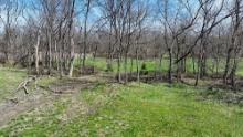
This tract consists of approximately 160± more or less and according to the county F.S.A. office there is 66.5 cropland acres with 49.9 acre wheat base and a 24 bushel yield. This farm is all in good native and improved grass pasture, creek, and timber. There is an old set of improvements located on this property (not livable), electric power, older water well, nice pond surrounded by good large timber, barn and small out buildings. There appears to be rural water at the NE/corner of property. Principal soils are Fortyone Sandy Loam, class III; Texroy Loam, class III; Selman Silt Loam, class III; Abbie Loam, class III; Woodward-Quinlan Complex, class III and some Westola-Quinlan Hardeman Complex, class VI. Farm has great access by most blacktop road with good county rock roads on north and east. This is an excellent cattle farm with added hunting, and recreation! Minerals: Selling surface rights only! Possession: will be given at closing. Wind Lease: There is NO wind lease on this property Order of Auction: Tracts will be sold individually in the advertised order. Internet Bidding: will be available by logging on to www.lippardauctions.com to register. Neither the auction company nor the seller is responsible in the event of loss of signal by either side. Terms/Conditions: 10% of the total purchase price is to be placed in escrow the day of the auction with the balance being due upon delivery of marketable title. All information has been taken from sources believed reliable; however, no guarantee is being made by the auction company or the seller. Buyers should satisfy themselves as to any inspection prior to bidding. Any announcements made the day of supersede all advertising.

Payment

Terms: 10% of the total purchase price is to be placed in escrow the day of auction with the balance being due upon delivery of marketable title. Real Estate: 10% down day of the auction by wire transfer only. Balance will be due within 30 days of auction. There are no contingencies on sales.
CheckMoney OrderWire TransferPayPal

Auction Details

9/15- 560± ACRES * HARPER COUNTY OK108 Temple Houston Dr., Woodward, OK, 73801Tuesday, Sep 15, 2015 | 10:00 AM CDT

Terms Of Sale

All information is taken from sources believed reliable; however, no guarantee is made by the auction company or the seller. Buyers should satisfy themselves as to any inspections prior to bidding. Any announcements made the day of auction supersede all advertising. Closing in approximately 30 days from auction. Wiring Instructions: Will be provided. All property is sold "AS IS", and ALL SALES ARE FINAL. Property is open to the public inspection. It is the Bidder?s responsibility to determine condition, age, genuineness, value or any other determinative factors. Lippard Auctioneers Inc. may attempt to describe the merchandise in advertising, on the Internet and at the auction but makes no representations. In no event shall Lippard Auctioneers Inc. be held responsible for having made or implied any warranty of merchantability or fitness for a particular purpose. Bidder shall be the sole judge of value. Lippard Auctioneers Inc will not be responsible for any missed bids from any source. Internet bidders who desire to make certain their bid is acknowledged should use the proxy-bidding feature and leave their maximum bid 24 hours before the auction begins. Lippard Auctioneers Inc reserves the right to withdraw or re-catalog items in this auction.
1.3.206.7be733a